• Welcome to TalkWeather!
    We see you lurking around TalkWeather! Take the extra step and join us today to view attachments, see less ads and maybe even join the discussion.
    CLICK TO JOIN TALKWEATHER

Severe WX January 10-12, 2020 Severe Weather Forecast Thread

Kory

Member
Messages
4,928
Reaction score
2,119
Location
Tuscaloosa, Alabama
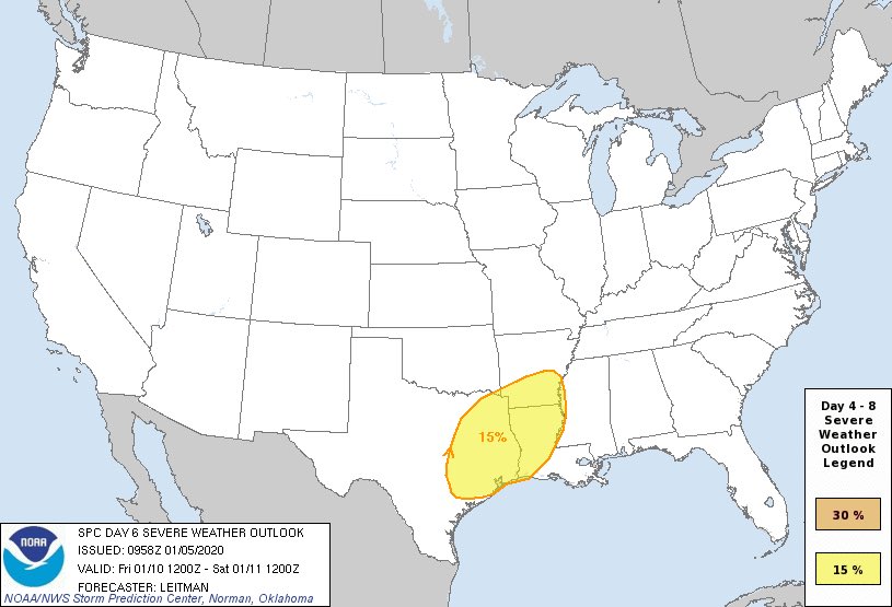
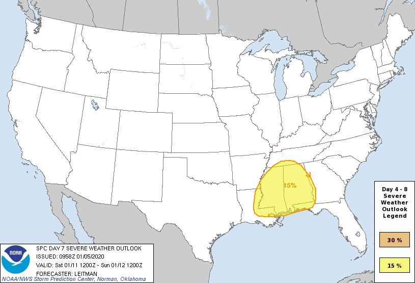
Looks like the period that has been extensively discussed in the 2020 severe wx threat has been highlighted by the SPC for the Day 6/Day 7 outlook. This has been a consistent signal and there looks to be continued threats beyond this one, but this looks like the initial one that kicks off an active stretch.

Day 6:
ENhREriXsAAKqQh.jpg


Day 7:
ENhMQn7VAAEkEyU.jpg:large
 

Mike S

Administrator
Staff member
Administrator
Moderator
PerryW Project Supporter
Messages
1,991
Reaction score
1,117
Location
Meridianville, Al
Special Affiliations
  1. SKYWARN® Volunteer
I found this thread on Twitter from SPC met Evan Bentley interesting regarding the rarity of a January Day 7.

It is an extended discussion so if interested click on the tweet below(you don't need an account to read) and then scroll down as he discusses the topic in multiple tweets.


TCLwx

Member
Messages
109
Reaction score
68
Location
Tuscaloosa, AL
I found this thread on Twitter from SPC met Evan Bentley interesting regarding the rarity of a January Day 7.

It is an extended discussion so if interested click on the tweet below(you don't need an account to read) and then scroll down as he discusses the topic in multiple tweets.


Very interesting. Any idea how long SPC has been going out as far as D7?
 

Mike S

Administrator
Staff member
Administrator
Moderator
PerryW Project Supporter
Messages
1,991
Reaction score
1,117
Location
Meridianville, Al
Special Affiliations
  1. SKYWARN® Volunteer
Very interesting. Any idea how long SPC has been going out as far as D7?

I think the Day 4-8 came along in the mid 2000's
 

Gail

Member
Messages
398
Reaction score
579
Location
Caledonia, MS
We had a tornado hit our town, just feet from my house, on Jan 10, 2008. That date is giving me a little anxiety. I could see this from my house. . It also destroyed some nearby homes.

A9BCF437-919D-4825-981B-FADA05886ADD.jpeg
 

MichelleH

Moderator
Moderator
Messages
861
Reaction score
1,181
Location
Cullman, AL
The last major January tornado I can remember that went through my area was the F3 tornado of January 19. 1988. Remember that VERY well. It did a lot of damage in the city of Cullman and there were 35 injuries, but thankfully no deaths.
 
Messages
150
Reaction score
204
Location
Flowery Branch, GA
HAM Callsign
KM4JKH
Special Affiliations
  1. SKYWARN® Volunteer
Something interesting to watch for sure. The ECMWF Hi-Res 12z paints a pretty nasty scenario for not only Alabama on Sat, but quickly moves it into Georgia Sat night. Forecast soundings show a STP of 2+ with what might be discrete (at least broken line) cells in the area. Not a good look, but it is in the voodoo range so probably will change.

Went back and watched the STP (Sig Tor) presentation by lead SPC forecaster, Rich Thompson from a couple years ago. If you haven't seen it, it's worth a view.
 

Kory

Member
Messages
4,928
Reaction score
2,119
Location
Tuscaloosa, Alabama
The majority of GFS ensembles look like the euro which are a significant threat. Only fly or two in the ointment might be the surface to 3KM lapse rates (which won’t be a problem if this thing comes through peak heating) and if this amplifies anymore. Euro looks to have gone more lower amplitude with the wave at 12z but did speed it up a touch.
 

Mike S

Administrator
Staff member
Administrator
Moderator
PerryW Project Supporter
Messages
1,991
Reaction score
1,117
Location
Meridianville, Al
Special Affiliations
  1. SKYWARN® Volunteer
I would love to know what dates the 4 times a day 7 was issued in the month of January....
Click on Evan Bentley's tweet that I posted. Once it opens start scrolling and it will tell you the dates with maps on how they verified.
 
X

Xenesthis

Guest
Click on Evan Bentley's tweet that I posted. Once it opens start scrolling and it will tell you the dates with maps on how they verified.
Thanks! Overall the trend of them verifying is currently 75%.. Pretty high odds
 

Jonathan Burleson

Member
Meteorologist
Messages
14
Reaction score
19
Location
Brilliant, AL
Special Affiliations
  1. SKYWARN® Volunteer
Oh, trust me I realize that. I will just be curious if this keeps the trend or not

I understand that line of thinking. I know there are only 4 samples, but you have to start somewhere. I'm a percentage kind of person myself, so I understand.

As far as this system is concerned, timing is really different depending on what of both the GFS and Euro that you look at, and that changes what may be the eventual outcome.

This system does have my attention and I do believe it may be the start of an extended tornado season, starting now and ending in middle March here in the Dixie Alley.

Again, these are just my opinions. Just long all of us, I'm still learning, and always will be.
 

Timhsv

Member
Messages
410
Reaction score
691
Location
Meridianville, AL.
Special Affiliations
  1. SKYWARN® Volunteer
You Retweeted


Evan Bentley

@evan_bentley


What are the takeaways? A D7 outlook area is rarely issued. Especially in January. Therefore, everyone should keep a close eye on the weather as we approach next weekend. However, it is important to remember, these past events were 30% probs and not 15%.
 
Messages
1,032
Reaction score
1,223
Location
jackson tennessee
Special Affiliations
  1. SKYWARN® Volunteer
If the mid level jet is being under estimated ... instability and cape will be higher... going be interesting watching models moving forward as we get closer when meso Data becomes very important for the event...
 
X

Xenesthis

Guest
If the mid level jet is being under estimated ... instability and cape will be higher... going be interesting watching models moving forward as we get closer when meso Data becomes very important for the event...
Honestly I think that will be the issue for this system. The wind profile s may be there but instability will be lacking further north. I don't see anything major north of the middle of AR, MS, and AL
 
Back
Top