

Hearing another bigger YouTuber say a bigger tornado event. Im guessing it's the consensus people are confident in saying it nowThe potential is definetely there, but I'd typically wait till D2 to definitively say "tornado outbreak possible"
Follow along with the video below to see how to install our site as a web app on your home screen.
Note: This feature may not be available in some browsers.
Hearing another bigger YouTuber say a bigger tornado event. Im guessing it's the consensus people are confident in saying it nowThe potential is definetely there, but I'd typically wait till D2 to definitively say "tornado outbreak possible"
In terms of lots of supercells?Also, its the 06z NAM at the end of its run so take it with the entire salt lake, but it has some utter bull**** in AL/FL as it makes landfall. Will have to see if it holds serve. Naturally I would post a sounding, but I cant from where I'm at.
In terms of the environment. NAM paints a solid EML with 500+ 1km SRH, 650+ 3km SRH, and 70-80 knots of 0-3 km shear all along the right-front quadrent/outerband (AL coast and FL Panhandle specifically) as it begins to make landfall.In terms of lots of supercells?

i have a hunch that most major youtube/content creators in the weather space tend to overexaggerate with their wording.Hearing another bigger YouTuber say a bigger tornado event. Im guessing it's the consensus people are confident in saying it now

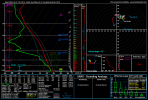

Big numbers..In terms of the environment. NAM paints a solid EML with 500+ 1km SRH, 650+ 3km SRH, and 70-80 knots of 0-3 km shear all along the right-front quadrent/outerband (AL coast and FL Panhandle specifically) as it begins to make landfall.
Vertical velocity on NAM shows 1-2 bands of supercells aswell.
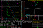
Getting shades of Milton outbreak.. hopefully not as it was Florida’s largest tornado outbreak.12z NAM has an eastward shift but otherwise, the modeled environment has stayed the same. From the FL Panhandle:
View attachment 55152
Great low level shear and significant drying above the 850 mb layer. But also, the CAPE appears oddly high for a tropical event, with numbers from 1700 to 2000 CAPE, and ~160 3CAPE.
This would probably help storms sustain tornadoes longer and increase intensity taken verbatim. Tropical induced Tornado Outbreaks dont need a lot of CAPE to produce tornadoes. They have occured in sub 500 CAPE TC environments. If this outcome were to occur exactly, we might have several strong+ tornadoes on the ground raking across FL and AL or moving on shore eith the arc of supercells being depicted on the majority of model runs.
Good to knowI've mentioned this before, but Noah Bergren was covering the 12/2021 Western Kentucky tornado with Trent Okerson for WPSD in Paducah. He knows his stuff.
Yep, Bergren is not one who tends to exaggerate, definitely adds to my raised eyebrows. The presence of dry air in the mid levels is really interesting for a tropical cyclone, not sure how often it happens but is definitely not the norm.I've mentioned this before, but Noah Bergren was covering the 12/2021 Western Kentucky tornado with Trent Okerson for WPSD in Paducah. He knows his stuff.
.LONG TERM...
(Thursday night through Tuesday)
Issued at 328 AM EDT Wed Oct 7 2026
A rather complex setup in the long term, with the main feature of
concern being the evolution of now Tropical Depression 9. Models
remain highly confident in the development of the Depression likely
into a hurricane by Friday, however uncertainty is high when it
comes to the track, forward speed, and intensity over land. The
upper level flow is rather unique with this system. The polar jet
will be well to the north Friday night into Saturday, with a large
ridge over the central CONUS. The subtropical jet, on the other hand,
will be stretched across the southern CONUS with a fast moving
shortwave ejecting off of Texas and a wave break off the southern
California coast. The eastern wave will likely provide enough shear
to transition the tropical system to an extratropical one. However,
models notoriously have trouble realizing the interactions between
two systems of near equal size. Furthermore, the large amounts of
adiabatic heat release will work to amplify the wave and add more
complexity to the mix.
So there remain several unanswered questions as the system develops:
1.) How much eastward momentum will the system have as it is
launched northward by the developing shortwave?
2.) How strong will the system be when this process starts?
3.) How far east will the system make landfall?
All of these will determine the initial hazards of the system
including tornado threat (how close are we to the front right
quadrant?), wind threat, as well as the initial flash flooding
threat.
As we move into later Saturday, the concern will likely move towards
heavy rainfall. Most models and ensembles bring the system almost
due north before re-curving under the larger ridge into the east-
central CONUS. However, I would be a fool not to mention a few
models which stand out. These include the Google GenCast, the 10/6
12z GFS, and the CMC, which stand out for a couple reasons. These
members realized either a more eastward landfall closer to the
Mobile/Pensacola region, or deviant motion after landfall holding
rain across the gulfcoast states. Now, this is just 3 members of a
much larger set of models, however the dynamics behind these runs
are not out of the realm of possibility and should still be kept on
the backburner.
The upper level feature to watch leading up to landfall will be the
subtropical shortwave off the California coast. This feature, a wave
break pattern shown well in the 2PVU surface, will be very difficult
for models to represent well (especially given the 2 pacific
tropical systems impacting it) and could initiate tertiary deviant
motion in the already complex shortwave/tropical interaction. This
is really only true, though, in the case of a system with initially
slower movement. The 18z GFS run shows this in its shift back west
post-landfall, as the TD initialization realigned closer to the
actual TD low center determined by the NHC. Should we see stalling
in the system after landfall, the threat for both flash/riverine
flooding and potentially tornadoes could change.
Development of the wedge may even further complicate things on
Saturday due to high pressure off the northeast coast driving low
level E flow around the Appalachians. Isentropic lift could focus
precip along the edge of the wedge and increased low level shear may
enhance tropical rotation or cut it off from the surface.
Widespread rainfall seems almost certain. The NBM ensemble indicates
a 70% chance of at least 1" of rain over nearly the entire CWA,
though areas typically impacted by the wedge may have higher
uncertainty.
While the system may take a while to fully clear PoPs from the area,
once the shortwave kicks through conditions warm back into the
80s.
&&

There is a lot less CAPE here given the dry air entrainment. The profile may say upwards of 3k SBCAPE but half of that is cut down to 500-1k in reality in this profile. Meaning cells would struggle to sustain amidst the shear in play, but of course, very strong height falls too.12z NAM has an eastward shift but otherwise, the modeled environment has stayed the same. From the FL Panhandle:
View attachment 55152
Great low level shear and significant drying above the 850 mb layer. But also, the CAPE appears oddly high for a tropical event, with numbers from 1700 to 2000 CAPE, and ~160 3CAPE.
This would probably help storms sustain tornadoes longer and increase intensity taken verbatim. Tropical induced Tornado Outbreaks dont need a lot of CAPE to produce tornadoes. They have occured in sub 500 CAPE TC environments. If this outcome were to occur exactly, we might have several strong+ tornadoes on the ground raking across FL and AL or moving on shore eith the arc of supercells being depicted on the majority of model runs.
That makes sense yeah. Only some of the CAPE would be usable from the dry air entrainment.There is a lot less CAPE here given the dry air entrainment. The profile may say upwards of 3k SBCAPE but half of that is cut down to 500-1k in reality in this profile. Meaning cells would struggle to sustain amidst the shear in play, but of course, very strong height falls too.
