• Welcome to TalkWeather!
    We see you lurking around TalkWeather! Take the extra step and join us today to view attachments, see less ads and maybe even join the discussion.
    CLICK TO JOIN TALKWEATHER

Hurricane Ida

bwalk

Member
Messages
597
Reaction score
291
Location
Prattville, Al
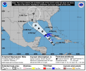
Invest 99L a possible Category 5 ........according to Facebook wanna-be mets (8/25/21).

Based on single model guidance figures (while overlooking the rest of the larger ensemble data) Invest 99L is being trumpeted as a potential Cat 5 hurricane that will strike the LA coast early next week.

Of course, even a stopped clock is right twice a day. This system does bear watching - but at this point - no one can know what it will become & do.


1629919358763.png
 

warneagle

Member
Messages
3,729
Reaction score
3,208
Location
Arlington, VA
Special Affiliations
  1. SKYWARN® Volunteer
The northwest Gulf is certainly very warm (and the warm layer is very deep) and it hasn't really been affected by tropical systems yet this year, which is concerning.
 

Fred Gossage

Member
Meteorologist
PerryW Project Supporter
Messages
596
Reaction score
2,095
Location
Florence, AL
Convection is quickly developing near the center of a mid-level swirl that developed and maintained itself this afternoon under the evolving outflow pattern on the north end of the wave axis in the Caribbean. The 18z GFS was on a more north/east track because it initialized near this feature instead of farther south/west on the wave axis, where the Invest center is declared. It's becoming increasingly apparent that the northern end is becoming dominant, and even aside from models, there are meteorologically sound reasons why. Areas farther south will be under the influence of stronger shear. That would inhibit organization. Aside from that, a tropical wave is an inverted trough. Think about shortwaves on the 500mb map but turn one upside down. The strongest cyclonic curvature and vorticity is on the NORTH side of the wave axis, not the south side. Think about how it's the south side of an LLC on a tropical wave axis that is last to close off. That's why. GFS/Euro ensemble members that were on more westerly/southerly tracks were all initiating off the more southerly/westerly portion of the wave axis. Ensemble members on the Louisiana path were initializing on the north end of the wave axis and where this MLC with rapidly developing convection is located.

The thing about this north/east track... yes, it's over water for a shorter amount of time, but it would track along the entire spine of the Gulf Loop Current, including that infamous eddy south of the marshes of southeast Louisiana that aided in rapid intensification of multiple systems in 2005.
 

Fred Gossage

Member
Meteorologist
PerryW Project Supporter
Messages
596
Reaction score
2,095
Location
Florence, AL
Satellite data is already suggesting that convection is beginning to develop banded organization. With trade winds not as strong as you'd usually see (less resistance to get a circulation to close off in the low-levels), we may see a depression close off down there tomorrow instead of waiting until Friday or after. I think this convective development is speeding up the timetable of development a bit.
 

Taylor Campbell

Moderator
Moderator
PerryW Project Supporter
Messages
2,102
Reaction score
2,189
Location
Wedowee, AL
Special Affiliations
  1. SKYWARN® Volunteer
Invest 99L is rapidly becoming a problem for the northern Gulf coast. Forecast track and intensity models indicate a fair possibility at a category 3 or stronger hurricane landfall in roughly 96 hours along the Louisiana coast. This would be as soon as Sunday night and early Monday.
 

Taylor Campbell

Moderator
Moderator
PerryW Project Supporter
Messages
2,102
Reaction score
2,189
Location
Wedowee, AL
Special Affiliations
  1. SKYWARN® Volunteer
I created a dedicated thread for Invest 99L. Mods, can you please move related posted to the new thread. We are seeing an increasingly dangerous situation. Thank you!
 

Brice Wood

Member
Messages
295
Reaction score
181
Location
Virginia
Haven’t seen this much serious attention on a tropical system since Michael, but that’s a good thing cause this potential storm needs to have a close eye on it
 

warneagle

Member
Messages
3,729
Reaction score
3,208
Location
Arlington, VA
Special Affiliations
  1. SKYWARN® Volunteer
We have TD Nine. No "M" on the forecast track for now at least.
 

Attachments

  • 1629989539846.png
    1629989539846.png
    663.1 KB · Views: 0

Mike S

Administrator
Staff member
Administrator
Moderator
PerryW Project Supporter
Messages
1,991
Reaction score
1,115
Location
Meridianville, Al
Special Affiliations
  1. SKYWARN® Volunteer
From TD 9 Advisory 1

Maximum sustained winds are near 35 mph (55 km/h) with higher gusts.
Steady strengthening is forecast during the next few days. The
depression is expected to become a tropical storm tonight, and
become a hurricane when it is near western Cuba or over the
southeastern Gulf of Mexico. Additional strengthening is likely
over the Gulf of Mexico and the system could be near major
hurricane strength when it approaches the northern Gulf coast.

The estimated minimum central pressure is 1005 mb (29.68 inches).
 

warneagle

Member
Messages
3,729
Reaction score
3,208
Location
Arlington, VA
Special Affiliations
  1. SKYWARN® Volunteer
Really looks like all the players are on the field for this one, to borrow a term from tornado season.


barcncpt44

Member
Messages
277
Reaction score
148
Location
Anniston, AL
Special Affiliations
  1. SKYWARN® Volunteer
Keep in mind, the Gulf Coast is dealing with a major COVID outbreak with hospitals overwhelmed.
 

Fred Gossage

Member
Meteorologist
PerryW Project Supporter
Messages
596
Reaction score
2,095
Location
Florence, AL
18z best guidance initialized as a 1004mb TS. Convection (during diurnal min) is rapidly developing and starting to twist near what should be the center of circulation. Unless recon is about to find something radically different, we are likely to have NHC officially declare Ida on the board in a little over an hour from now.
 

TornadoFan

Member
Messages
2,472
Reaction score
2,225
Location
Colorado
Actually, the NHC JUST posted an update:

Tropical Storm Ida Tropical Cyclone Update
NWS National Hurricane Center Miami FL AL092021
520 PM EDT Thu Aug 26 2021

...AIR FORCE PLANE FINDS DEPRESSION A TROPICAL STORM...

Air Force Reserve hurricane hunter aircraft data indicate that the
depression has strengthened to Tropical Storm Ida. The maximum
sustained winds are estimated to be 40 mph (65 km/h) with higher
gusts.


SUMMARY OF 520 PM EDT...2120 UTC...INFORMATION
----------------------------------------------
LOCATION...18.0N 79.8W
ABOUT 100 MI...160 KM WSW OF NEGRIL JAMAICA
ABOUT 130 MI...205 KM SE OF GRAND CAYMAN
MAXIMUM SUSTAINED WINDS...40 MPH...65 KM/H
PRESENT MOVEMENT...NW OR 325 DEGREES AT 14 MPH...22 KM/H
MINIMUM CENTRAL PRESSURE...1006 MB...29.71 INCHES

$$
Forecaster Brown
 

Mike S

Administrator
Staff member
Administrator
Moderator
PerryW Project Supporter
Messages
1,991
Reaction score
1,115
Location
Meridianville, Al
Special Affiliations
  1. SKYWARN® Volunteer
Not much has changed as of 7pm CDT

1630028066988.png
 

Mike S

Administrator
Staff member
Administrator
Moderator
PerryW Project Supporter
Messages
1,991
Reaction score
1,115
Location
Meridianville, Al
Special Affiliations
  1. SKYWARN® Volunteer
New advisory out. Timing has changed as landfall is now expected Sunday evening instead of Sunday afternoon. Hurricane watches now along the Louisiana and Mississippi coasts and a tropical storm watch along the Alabama coast.

WATCHES AND WARNINGS
--------------------
CHANGES WITH THIS ADVISORY:

The Storm Surge Watch has been issued from Sabine Pass to the
Alabama/Florida border including Vermilion Bay, Lake Borgne, Lake
Pontchartrain, Lake Maurepas, and Mobile Bay

A Hurricane Watch has been issued from Cameron, Louisiana eastward
to the Mississippi/Alabama border, including Lake Pontchartrain,
Lake Maurepas, and metropolitan New Orleans.

A Tropical Storm Watch has been issued from the Mississippi/Alabama
border to the Alabama/Florida border.


Logo 468x120
Back
Top