• Welcome to TalkWeather!
    We see you lurking around TalkWeather! Take the extra step and join us today to view attachments, see less ads and maybe even join the discussion.
    CLICK TO JOIN TALKWEATHER
Logo 468x120

Iceland's Fagradalsfjall Fires

bjdeming

Member
Sustaining Member
Messages
1,593
Reaction score
1,310
Location
Corvallis, Oregon
Here is Isak's drone video today -- fire and ice flurries can be mesmerizing.


Otherwise, everything appears to be stable except on the Grindavik barrier where they are already making a dramatic difference in the wall's outline. Wonder how they are handling the weakness along the contact with the old top surface.

Air quality currently is very bad in the Grindavik area, and overnight the pollution is expected to shift more toward the power plant and some communities in that general direction.

RUV reports that lava filled the quarry, but that branch apparently is now following a January 14th flow path towards what I think is a coastal road rather than threatening the wall.
 

bjdeming

Member
Sustaining Member
Messages
1,593
Reaction score
1,310
Location
Corvallis, Oregon
Per RUV (autotranslated):

"Based on what has been seen on webcams last night, it seems that the activity in the craters has decreased a bit. Right now, several craters are still active, but one or two may have gone out during the night, but maybe four craters remain active," says Einar Bessi Gestsson, a geologist at the Norwegian Meteorological Agency.

Is this the first time that the eruption has subsided? "Yes, after the first 24 hours, which was much more powerful, the eruption has been quite stable. It is difficult to visually assess small changes that may have occurred in the eruption, but tonight it seems that there were quite clear indications that it reduced the activity in the craters a little.
What does this mean? Is it perhaps difficult to predict? " It is always difficult to predict this. This is often the trend in this that it slowly reduces such eruptions. We just have to wait and see. I don't think these are big changes. We really just have to see if it stays constant in this phase it's getting into now or if it slowly tapers off. It just has to be revealed."

This layperson would feel happier about the news if IMO hadn't confirmed in their update (autotranslated) on March 22 23 that mild landrise has continued since the eruption's onset.

It could be that the eruption is just consolidating more; I have been wondering what was keeping so many craters active for so long.

Or it might be winding down. On the cam, though, activity in the two biggies doesn't appear to be lessened much,, if at all.

PS: On further reading, have learned that Iceland's lava shields probably form during eruptions where the flow rate is thousands of cubic meters per hour, which thankfully is not the case now
 
Last edited:

bjdeming

Member
Sustaining Member
Messages
1,593
Reaction score
1,310
Location
Corvallis, Oregon
No major new update yet. A geoscientist note from about three hours ago describes the eruption as stable (and there is also a little seismicity at Askja, farther east, but no change in its status from 'Normal").

Magnus Tumi spoke (autotranslated) with Morning Paper; read the whole thing, but a couple highlights are:

...
there are indications that the turbulence has decreased in the volcanic eruption at Sundhnúka crater in the last two days and that the activity is a little less in the craters.


"It is not possible to draw much conclusions from this as of now"

...


Magnús says that the GPS measurement system maintained by the Norwegian Meteorological Agency, the University's Institute of Geosciences and other parties shows that there is not a land subsidence but a slight land subsidence, which indicates that although it is erupting, it is flowing into the magma reservoir under Svartsengi.


"We don't see any signs that the magma influx is slowing down." What the future holds remains to be seen...

Magnús says there is uncertainty about the future. He says that the eruption may end soon, but then landris will probably start in full force because there are no signs that the magma flow is stopping.


"The eruption can also continue for some time. If we look at previous volcanic eruptions in this area, in those events there was much more lava than what is now in this area. It doesn't prove anything but the way the Reykjanes peninsula behaves and these eruptions that happened in the 13th century - then you have to expect that there will be a lot more magma coming up before it sees the end of these events. We have to prepare for a long run."

From my reading, every system on the peninsula except Fagradalsfjall went off at various points in time between 800 and 1200 AD or thereabouts. Each system hosted multiple events, each lasting for weeks to months.

Then things got quiet for some eight centuries. There is a theory -- sources will be listed in an eventual blog post -- that this part of the midocean ridge sometimes extends for several centuries and then switches over to magmatism for several centuries.

There is much disagreement about many points of Iceland geology and volcanism, but apparently consensus exists that the Reykjanes Peninsula segment has done that latter thing and that volcanism will be part of the picture here for at least the next couple of centuries.
 

bjdeming

Member
Sustaining Member
Messages
1,593
Reaction score
1,310
Location
Corvallis, Oregon
Official update:

The eruption seems to have subsided​


High levels of sulfur dioxide were measured over the weekend. Unchanged hazard assessment.​


25.3.2024


Updated March 25 at 15:00


  • High levels of SO 2 (sulfur dioxide) were measured over the weekend. You can follow the gas distribution forecast here .
  • This concentration is considered very unhealthy. It is important to pay close attention to the development of air quality .
  • The eruption at Sundhnúksgíga seems to have subsided
  • Risk assessment unchanged . There is still an increased risk due to gas pollution


It seems that the eruption at Sundhnúksgíga has subsided in the last 24 hours. Crater activity is lower and possibly extinguished in the smallest craters. Also, eruption turbulence has decreased very slowly over the past few days. The main lava flow flows from the craters first to the south and then turns to the west. Over the weekend, lava continued to flow into Melhólsnámina and has now filled it, but continues to thicken closer to the craters.


GPS measurements of the last few days indicate that landris is running in Svartsengi, but much slower than before. It indicates that magma is still accumulating in the collection area under Svartsengi, even though there is an ongoing eruption.


They also discuss pollution levels, which were extreme in Grondavik on Saturday.
 

bjdeming

Member
Sustaining Member
Messages
1,593
Reaction score
1,310
Location
Corvallis, Oregon
No news, although there might be some work activity going on at a corner of the Grindavik barrier on the mbl.is cam.

I just was reading this paper, and when I got to one section describing the big magma dike intrusion on November 10, it reminded me so much of what it's like watching a severe weather system move through online -- only geology isn't supposed to happen this fast.

What do you think? (Background: At that point they knew they had a large-volume sill, about 5 km down and extending from the Sundukhnuk craters westward under Svartsengi plain to the Eldvorp crater row where, I think, the last peninsula eruptions happened back in the 1200s, and the seismicity it caused had been rising since October 25. Afterwards they calculated that, between 1900 and 2000 UTC on the 10th, magma down there was flowing at about 7400 cu m/s or many tens of times faster than Iceland's biggest river):

Around 7:00 UTC on 10 November 2023, rapid low-magnitude seismicity, typical of subsurface magma migration (24), started at 4- to 6-km depth under Sundhnúkur crater row, gradually moving 3.5 km northward to Stóra-Skógfell over the next 8.5 hours (Fig. 1C and figs. S13 to S16). We did not detect surface deformation signals during this time. Southward migration of the seismicity commenced after a MW 4.1 event at 15:23; thereafter, seismic propagation occurred both to the north and the south (Fig. 1E). The propagation to the south was faster, and the events much larger than on the northern segment. At 16:56, a MW 4.8 earthquake occurred just north of Mt. Hagafell, and more events immediately followed. At 18:01, a MW 5.2 event occurred at Hagafell, followed by a continuous swarm of small and large events that advanced at a fast pace toward Grindavík. By 18:30, the events had reached the town of Grindavík, and by 19:30, earthquakes were detected south of the town. From just before noon on 10 November until midnight, around 25 ≥MW 4 earthquakes occurred, two of which were of ~MW 5.2. At 16:40, deformation commenced at high rates as detected by the GNSS network (Fig. 2 and fig. S7). Horizontal and vertical deformation reached 1 m by 20:00, after which deformation rates and seismicity decreased. The temporal evolution of GNSS displacements shows that the northeast part of the dike expanded first, followed by the southwest part (fig. S6), which was in broad agreement with development of seismicity. Dike-induced extension was accommodated at the surface along dike-subparallel normal faults and fissures forming near Svartsengi and south, toward the coast, including the town of Grindavík (fig. S19).

No wonder the boffins were so excited then. It could have erupted -- and that peak rate is well within flood-lava range -- but, thankfully, it did not and has only reached the surface in relatively small ways since.

The idea (which this layperson is still digesting) is that this was an unusual way for such a dike to form, and that it was probably aided by plate boundary movements releasing a lot of stored tensile stress.

Gonna think about that some more...
 

bjdeming

Member
Sustaining Member
Messages
1,593
Reaction score
1,310
Location
Corvallis, Oregon
No new volcano news, but this human story is amazing -- last night on the cams it looked as though work lights were actually running between the barrier and the lava at the barrier's feet.

Yeah, right, I thought, they're mining fresh lava for the wall. Uh huh

Well, yes:

Freshly flowed lava used to raise the ramparts​

Margrét Björk Jónsdóttir writes March 26, 2024 7:20 p.m
Here, a digger is using recent lava to strengthen the rampart.
Here, a digger is using recent lava to strengthen the rampart.INDICATOR/ION OF VICTORY

Contractors are now working around the clock on defenses around Grindavík before the welcome Easter break. Newly flowed lava is used to raise the gardens...

-- Source (auto translated)

General Patton bombed an erupting Mauna Loa once, to try and save Hilo (actually he was a colonel at the time), but he never went mano a mano with Pele.

While working overtime so he could then take an Easter break.

I might have underestimated the "berserker mode" setting here somewhat. (Not that this is a bad thing -- am 100% behind H. sapiens in this match!)
 

bjdeming

Member
Sustaining Member
Messages
1,593
Reaction score
1,310
Location
Corvallis, Oregon
RUV published an in-depth report (autotranslated) on volcanic threat to the capital area (the headline translation is misleading, but the rest of the article appears to be good and it has interviews from the lead author on that study linked above, as well as with Pall Einarson and some IMO names that I recognize from earlier media articles).

Nothing appears to be imminent there, but the 2021 to early 2023 Fagradalsfjall fires are just over the hill from Reykjavik (in what IMO considers to be part of the Krysuvik system, not a separate volcanic system of its own).

And as they say, the whole peninsula is waking up. Grindavik/Svartsengi was a crisis; now that (hopefully) they have some time, of course boffins would start their new situational reviews at the capital area, along with public outreach like this article because of the population density there.

...Of course we have water supplies and all kinds of pipelines and electrical lines and roads and such," says Ásta Rut Hjartardóttir. The water sources of the capital area are actually within the volcanic system of Krýsuvík. She mentions Kaldársel, Vatnsendakrika and Gvendarbrunna. "Kaldársel is so close to being where you can see the more active part of the crack swarm," she says.

kveikur_krysuvik_2024.00_18_31_20.Still017.jpg

Although a chapter of upheaval has begun on the Reykjaness Peninsula, it is uncertain when the Krýsuvíkur system will wake up. It is possible that it will happen this year, but it could also happen in 100 years. However, it is not excluded that the landslide in Krýsuvík in the fall of 2020 gives some indication that the system is working.


"We have to take this seriously," says Páll Einarsson, "because in the last such upheaval cycle, which was shortly after settlement, the Krýsuvíkur system was fully involved, and indeed the Brennisteinsfjalla system as well, and that's where the biggest eruptions in that cycle occurred."


Bergrún Arna points out that although the Krýsuvíkur system starts to erupt, lava does not have to flow directly into Hafnarfjörður or directly into the capital area.


"But certainly we need to know that there is a possibility," she says.


Ásta Rut says that if magma tunnels start from the center of the volcanic system, it is also a question of how far they went. "It may well be that they would not rush anything to the capital area or anything in that direction," she says.


"So there's just a lot of uncertainty about how that would play out."


She agrees that serenity is what is needed. "And just prepare ourselves. I think it's one of the best things you can do."
 

bjdeming

Member
Sustaining Member
Messages
1,593
Reaction score
1,310
Location
Corvallis, Oregon
Nice satellite view of new lava flows and barriers through the 23rd; that's Grindavik in the lower left and the circular setup is around the power plant.


As for the eruption today:

Lovísa Mjöll Guðmundsdóttir, a natural disaster expert at the Icelandic Meteorological Office, says in an interview with mbl.is that there have been little changes in the eruption since yesterday.


"It continues to erupt in three craters with a similar force as yesterday," says Lovísa, but the northernmost crater is the largest.


She says that there was a slight increase in the sulfur dioxide values last night and this morning, but not enough to have a reaction to it.

-- Source (autotranslated)
 

bjdeming

Member
Sustaining Member
Messages
1,593
Reaction score
1,310
Location
Corvallis, Oregon
There is no change in the eruption thus far, per the last online news sources I checked. The lava is causing small wildfires in moss and shrubs during this drier, windier weather and fire departments are doing what they can to keep these from turning into big ones, despite the remote location.

Barriers are still holding. Reportedly the fresh-lava mining was a temporary measure -- on thinking it over, it does make sense to use semi-molten material to build up an existing wall (if you can stand it!) -- there's probably a better seal.

This was tweeted about four hours ago, so "last night" is the 28th:


FWIW, this layperson thinks Iceland is safe to visit, but a backgrounder is needed so this blog post is the first of what should be a three-part series on that.

It includes that 2017 Grindavik/Svartsengi drone video again -- sigh. That area was so beautiful and peaceful.

Well, it will be again, and there will be people who can enjoy it. It's just a stressful time right now for everyone there.
 

bjdeming

Member
Sustaining Member
Messages
1,593
Reaction score
1,310
Location
Corvallis, Oregon
No changes, just an update on lava flows. First, place names graphic again:

f-_drkcxuaa9wmo.jpg


The gap between Hagafell and Sundukhnur reportedly (autotranslated) almost filled in, and you can see the effect on lava flow in this GIF:


Those two tiny straight lines at the flow's edge down in the left corner are Grindavik's barriers.

The portion climbing over the mountain's lowest slopes is visible on cams, including this one:


Good defense requires good models for predicting future lava flow movements -- quite difficult in this situation!
 

bjdeming

Member
Sustaining Member
Messages
1,593
Reaction score
1,310
Location
Corvallis, Oregon
From the blog this morning, addressing a challenge that often comes up in a lengthy crisis like this:

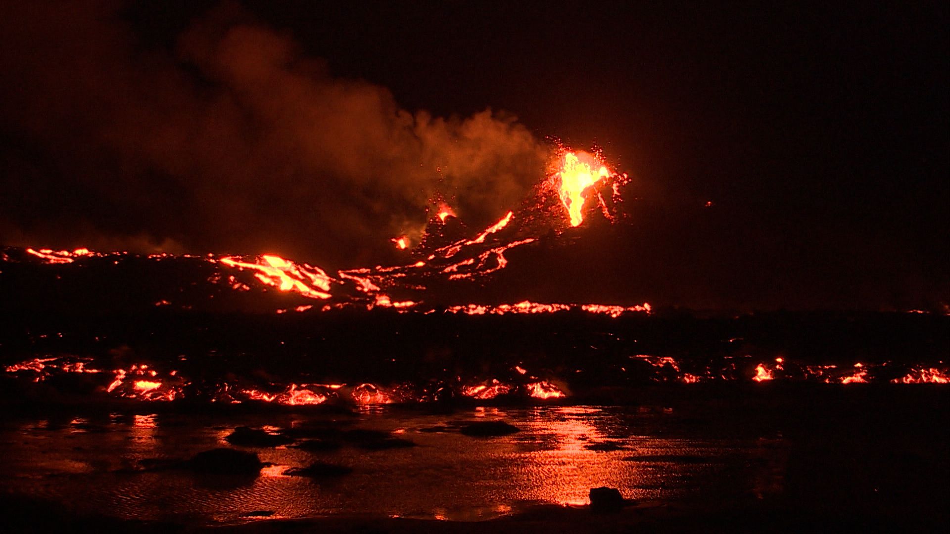
April 1, 2024, 4:22 a m., Pacific: Over the weekend, the southernmost crater stopped erupting. Now at the cam it appears that the middle crater is inactive (at least for the moment; nothing is mentioned about that in current online news).

Also, at the moment, activity in the main crater appears to be somewhat less.

A flurry of stories appeared Sunday afternoon about the possibility of an ending to the eruption; news articles quoted Thorvaldur and a group at the University of Iceland as saying that decreased thermal signature was a sign that the eruption was ending.

IMO, on the other hand, stated via Magnus Tumi what this layperson has always understood from her readings about volcano monitoring everywhere: thermal output gives important data but it cannot predict an eruption’s end.

As I understand it, two of the biggest unknowns in volcanology are still:

  1. At what point does eruption become inevitable during magma movements underground?
  2. How and why eruptions end.
And that’s just “normal” volcanism — in Iceland, spreading-ridge processes and ridge interactions with the hotspot melting anomaly must be considered, too.

I’m not sure why there is a discrepancy in the reported views of Icelandic volcanologists but it’s sad to see at such a time, with lava still flowing and so much still at stake.

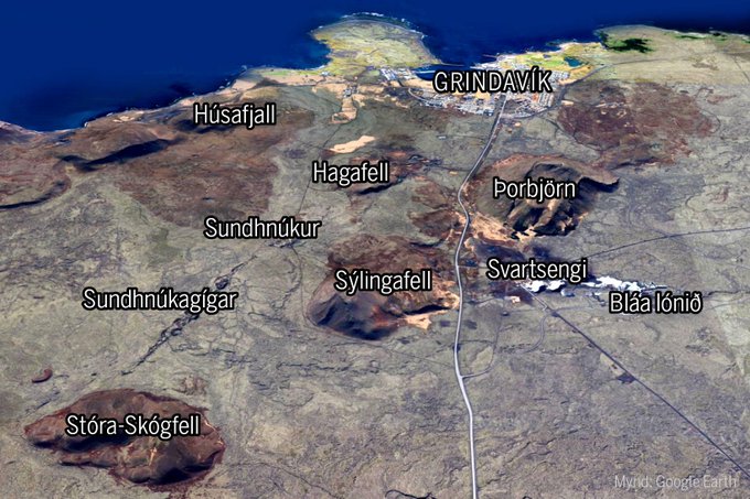
It might be something going on behind the scenes. I saw an interview a few weeks ago in which a government official said that there was no need for another volcanology organization, even though the Reykjanes Peninsula is waking up and will continue being intermittently active in the foreseeable future.

In other words, the government has confidence in volcanologists of the national weather service (which is what IMO is), while others outside IMO might want want to play an official role in future events and are now seeking for a way in.

Or it could be something else. This layperson has difficulty coming to grips with events in her own country, let alone somewhere else.

Nevertheless, this layperson does not see the recommended “speak with one voice” happening this past weekend, and the confusing “two voices” dichotomy, if formalized, would probably be worse for the public and others who are endangered by the “Reykjanes Fires.”

However, as this source notes:

The power of the single voice from the group of experts often misleads the receivers of the message…
That linked chapter goes into general volcano monitoring uncertainty with much jargon and in great detail. I’m not qualified to comment on it but do see the same emphasis on uncertainty in, as just one example, the quotes from Magnus Tumi in the linked news story above.

That approach to this very difficult situation on the Reykjanes Peninsula impresses me much more than do the other more sure-sounding views described above.

I think that the public ultimately appreciates more being told what they/we need to know than being told what they/we want to hear.
 

bjdeming

Member
Sustaining Member
Messages
1,593
Reaction score
1,310
Location
Corvallis, Oregon
Bottom line:


bjdeming

Member
Sustaining Member
Messages
1,593
Reaction score
1,310
Location
Corvallis, Oregon
No change, really, in IMO's update (autotranslated) today. That point about the landris is important ("vents" in this translation referring to the deep source feeding the sill, I think) -- the eruption is unlikely to stop soon. Earlier eruptions here made the sill deflate. (Of note, they have said repeatedly that the volume of lava erupted thus far has been quite small compared to earlier fires on the peninsula; perhaps that's about to change? At least the barriers are up and holding).:

The eruption at the Sundhnúks crater series continues and now two craters are active. It went out in the third crater at Easter, but it was much smaller than the other two. Erosion remains stable.

Landris in Svartsengi has not been observed in the last few days, which mainly indicates that the magma is less concentrated in the magma chamber under Svartsengi, but rather flows directly out of the vents. It is possible that a balance has been established in the flow of magma under Svartsengi and out of the craters, but geochemical measurements could confirm this in the near future.

Land Surveying Iceland experts have processed satellite data from March 27, which show that the lava width was then 5.99 km 2 and the volume of lava since the beginning of the eruption 25.7 ± 1.9 million. m3. The average flow of lava from the craters during the period 20 - 27 March was estimated at 7.8 ± 0.7 m3/s, but it is very comparable to the lava flow in the first phase of the eruption in Geldinga Valley in 2021. The aim is to take aerial photographs of the area in the coming days to obtain updated lava flow data from March 27 that would shed more light on the eruption's activity. The attached map shows the extent of the lava and its thickness as it was on March 27.

Map02042024


A map showing the extent and thickness of the lava formed during the current eruption. Purple covers show lava that has flowed in the area since December 2023.

Wildfires around the lava bed​

Recently, there have been wildfires around the lava bed, but there is a constant danger while the weather is dry.

Lava margins have become high in many places and glowing lava can fall from the lava rim and rapid and sudden advances occur as new lava tongues break out from the lava rim at high speed.

In recent days, high levels of hydrogen sulphide have been temporarily detected in Grindavík. The weather forecast today (Tuesday) is northeast and later east 5-13 m/s at the eruption stations. Gas pollution therefore travels to the southwest and later to the west, and it will probably be noticed every now and then in Grindavík and just as well in Höfn. East and southeast 3-10 m/s tomorrow (Wednesday) and gas pollution therefore reaches the west and northwest and could be measured in many places in the western part of Reykjaness, i.a. in Reykjanesbær. Gas distribution forecast is here .

Risk assessment unchanged​

The risk assessment has been updated and is valid from 15:00 today until April 9, all things being equal. There are no changes in the risk assessment and the risk caused by gas pollution is still assessed as high in all areas except for the Sundhnúks crater series (area 3) where it is assessed as very high. The risk in area 4 (Grindavík) and area 6 is still assessed as high due to landfall into the fissure, fissure movements, lava flow and gas contamination.

Haettusvaedi_VI_2april_2024
 

bjdeming

Member
Sustaining Member
Messages
1,593
Reaction score
1,310
Location
Corvallis, Oregon
RUV is doing a video series (autotranslated) on Grindavik. Wish I lived in their market and understood Icelandic. "In these episodes, we watch the lives of the Grindvíking people develop in line with the constant changes."

Otherwise, there is no update on the IMO website and the eruption continues on, mostly at the main crater. Just a few minutes ago, RUV posted an article (autotranslated), quoting Kristin as saying that inflation of the sill has begun again -- the translation says "subsidence" at one point, which doesn't fit the rest of the article's information on landrise and Kristin's point that more molten material is flowing into the sill than is coming out of it.

An mbl.is article the other day quoted Benedikt as saying that magma could be coming from as deep as 15 km or more, and that a single deep chamber underlies the peninsula. (They chased the poor guy down in Milan during his vacation! Then again, not so poor at that, to be vacationing there. :cool:)

This really goes against everything in my reading -- it's assumed the crust of the peninsula is "just" 12-15 km thick, in most papers I've read (just a smattering, really) and that each volcanic system there, however you name them, has its own reservoir at a fairly shallow level, around 5-6 km, which is also roughly the Svartsengi sill depth.

If those assumptions don't fit the data from these Fires, hazard management in Iceland's most populous region becomes much more problematical.

The University of Iceland's analysis of lava samples we saw Alberto collecting in those tweets (and probably others) shows that what is bubbling out of the ground now is pretty much the same as earlier lava from 2021 on, but the detailed petrological studies being done at, I think, the University of Cologne can reliably suggest its depth (thanks to that old pressure-temperature-phase triple-point business that was the bane of this 1980s geology undergrad).

Anyway, Benedikt reportedly said that they're waiting on test results to find out.

Deep magma movement is no more problematical than whatever changes, like seismicity, it might cause on the surface. That sill, for instance, has been there since at least 2020.

It's the connections from the depths to the surface that are crucial and AFAIK not well understood...especially in light of the shortened warning time that developed up through this eruption.

The rocky record shows that activity comes in cycles. There will be more Reykjanes eruptions over coming decades and centuries, but where? How? And how much?

There is literally no other place on Earth that volcanologists can turn to for an example.

It's sort of like if you had a severe weather system to forecast, but first had to invent the meteorological theory that would let you interpret your data and issue warnings.

Quite a conundrum.
 

bjdeming

Member
Sustaining Member
Messages
1,593
Reaction score
1,310
Location
Corvallis, Oregon
A little good news from the IMO update this afternoon (autotranslated) -- the lava movements are not causing lava to rise much on the barriers.

They also now have more data on the sill inflation, but that's not so good -- it's not terrible, either, but as they note, the eruption is likely to drag on and on.

"Suðurstrandarveg" is the South Shore Road and "Melhólsnámu" is that quarry that lava filled in. I don't know why it has a name

The eruption at the Sundhnúks crater series continues and two craters are still active as in the past few days. The northern crater is larger and most of the lava flow appears to be coming from it, as seen in the following photo taken last night, April 3rd. Lava continues to flow south from the craters on top of a lava bed formed in the first days of the eruption. Last night, there were no clear signs of lava advance at the dikes north of Grindavík, Suðurstrandarveg or Melhólsnámu.

Drone image04042024

Aerial photo from a drone flight by Almannvarna last night, April 3. The image shows the two craters and the lava flow from them to the south.

A waveform cross-section showing deformation from March 18 to April 3 shows that land has risen by 3 cm in Svartsengi during that period. It is considerably slower on land than was measured for the volcanic eruptions or magma flows that have occurred in recent months. Based on the GPS measurements during the same period, the speed of the land giant seems to have varied, but it can be difficult to assess changes from day to day based on them. If you look at the GPS measurements over the entire period that the wave interpolation shows, you can see that there is consistency in the results of both measurements. Landris measures in Svartsengi during the eruption, but this has not been seen in the events that have occurred in the last months in the Sundhnúksgiga series. It is an indication that the system is open and magma continues to flow from a great depth under Svartsengi and from there to the surface in the Sundhnúks crater series.

Csk_reykjanes_A33-krysuvik_20240318-20240403_unw


Waveform diagram showing deformation from March 18th to April 3rd. Yellow and orange colors show areas around Svartsengi where landris are measured.
 

bjdeming

Member
Sustaining Member
Messages
1,593
Reaction score
1,310
Location
Corvallis, Oregon
There is no major news -- it's down to one active vent now and IMO reports that the eruption rate appears stable. Next week they will do another survey to try and quantify any signs that the eruption might be tapering off.

What I wanted to share is this drone video in an Icelandic-language online article because it really shows what a neighborhood eruption looks like. They start off over Grindavik harbor, where businesses are trying to stay in operation, and then there are various views of the lava flows. It ends with a nighttime view of the erupting crater as seen over the Blue Lagoon (which, incredibly, has reopened again; tourists are flocking to it, too, but police are not letting them walk over to the eruption site from the parking lot -- that's how close it is; toxic gas levels are the main concern but thus far have been within tolerable limits).

Should things suddenly take a turn for the worse -- no sign of that, but surprises happen during eruptions -- evacuation and emergency response might be difficult. From news reports, it sounds like all of western Iceland and some other parts of the country are shut down from winter weather tonight.
 

bjdeming

Member
Sustaining Member
Messages
1,593
Reaction score
1,310
Location
Corvallis, Oregon
Per RUV (autotranslated), the spatter rampart wall collapsed two hours ago -- something that happened up in Fagradalsfjall, too -- but fortunately that lava is heading north, out into open country.

I've only found found one video of it so far:


bjdeming

Member
Sustaining Member
Messages
1,593
Reaction score
1,310
Location
Corvallis, Oregon
Per Morning Paper (autotranslated), this happened several hours before the collapse:

Direct: Lava cascades down the overflowing crater​


Screenshot from webcam at 20:30. Lava flows over the rim of the crater.

Screenshot from webcam at 20:30. Lava flows over the rim of the crater. mbl.is/Skjáskot


"It started happening at about 20 minutes past three, then the surface in the crater started to rise," says Elísabet Pálmadóttir, natural hazard expert at the Icelandic Meteorological Office, when asked about the lava flow that now flows down the rim of the crater during the eruption of the Sundhnúka crater series.

"Then it just started to overflow, but the crater itself did not break," says Elisabeth, adding that it is obvious that the flow of lava has increased.

Screenshot from webcam available after 16 today.

Screenshot from webcam available after 16 today. mbl.is/Screenshot

A slight increase in turbulence​


When asked, she says that it is not entirely clear what caused this increased lava flow, but two things are most likely to be considered.

It is possible that magma was sneaking under the lava and that the channels were blocked. Then more magma looked up over the table.

"It could also just be more volume coming up, we're seeing a slight increase in turbulence but it's a little too early to tell."
 

bjdeming

Member
Sustaining Member
Messages
1,593
Reaction score
1,310
Location
Corvallis, Oregon
IMO hasn't updated their website yet, so we'll have to wait and see.

From discussions I followed after the Fagradalsfjall crater collapses, these spatter ramparts are just a loose complex of blobs, sort of welded together but not as sturdy as a cone.

They do fail, but this rise in lava level is interesting.

Glad it isn't flowing south, even if the Grindavik barriers have been raised.
 

bjdeming

Member
Sustaining Member
Messages
1,593
Reaction score
1,310
Location
Corvallis, Oregon
I have no idea what she is saying, but there are nice shots of the overflow this afternoon. The spatter wall broke around 10:30 p.m., local time.

 
Back
Top