• Welcome to TalkWeather!
    We see you lurking around TalkWeather! Take the extra step and join us today to view attachments, see less ads and maybe even join the discussion.
    CLICK TO JOIN TALKWEATHER

Hurricane Hurricane Milton

Since Milton is transitioning to an extratropical cyclone and there is a lot of dry air in place, is it possible for a gravity wave to form on the backside of the system? I’ve never heard of gravity waves with hurricanes, but Milton is a very unusual hurricane.
 
One gets the feeling the I-4 corridor is about to get a drainage test.

1.5M without power now in FL.
 
10 PM NHC update.
000
WTNT64 KNHC 100156
TCUAT4

Hurricane Milton Tropical Cyclone Update
NWS National Hurricane Center Miami FL AL142024
1000 PM EDT Wed Oct 09 2024

...FLASH FLOOD EMERGENCY IN EFFECT FOR THE TAMPA BAY AREA AS
MILTON CONTINUES MOVING INLAND...
...1000 PM EDT POSITION UPDATE...

A sustained wind of 69 mph (111 km/h) and a gust of 102 mph (165
km/h) was recently reported at the Sarasota-Bradenton International
Airport. A sustained wind of 86 mph (139 km/h) and a gust of 105 mph
(169 km/h) was recently reported at a WeatherFlow station at Egmont
Channel. A sustained wind of 74 mph (119 km/h) and a gust of 98 mph
(157 km/h) was recently reported at a NOS station at Middle Tampa
Bay. A gust of 91 mph (146 km/h) was recently reported at a Citizen
Weather Observer Program station in Bartow.

A Flash Flood Emergency is in effect for the Tampa Bay area,
including the cities of Tampa, St. Petersburg, and Clearwater.
Albert Whitted Airport in St. Petersburg has received 16.61 inches
of rain so far today.

The next update will be the full advisory at 1100 PM EDT (0300
UTC).

SUMMARY OF 1000 PM EDT...0200 UTC...INFORMATION
-----------------------------------------------
LOCATION...27.5N 82.3W
ABOUT 20 MI...30 KM NE OF SARASOTA FLORIDA
ABOUT 90 MI...145 KM SW OF ORLANDO FLORIDA
MAXIMUM SUSTAINED WINDS...110 MPH...175 KM/H
PRESENT MOVEMENT...ENE OR 60 DEGREES AT 16 MPH...26 KM/H
MINIMUM CENTRAL PRESSURE...958 MB...28.29 INCHES

$$
Forecaster Reinhart/Mahoney
 
Big time surge continues in Venice, FL. At least Reed got out of the water this time.
 
Torrential rain continues in Tampa / Brandon. They've picked up another 3-4" in the hour since the last flash flood emergency was issued. Really dire.
 
St Pete has had 3.63" since the 5+" hour & a 101 mph gust. Tampa's gust are 84. The sustained winds aren't very strong though despite these gusts.
 
Some have mentioned possibly that the dry air wrapping around the back end of Milton is enhancing the winds. Not sure if that might be the case, but the winds are clearly very strong on Milton's west side.
 
What is a "Sting Jet", Alex.
 
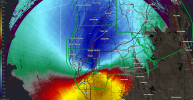
Given the current evolution of Milton, central into eastern Florida could see some very strong wind gusts as he moves across the center of the state.
1728529409659.png
 
Given the current evolution of Milton, central into eastern Florida could see some very strong wind gusts as he moves across the center of the state.
View attachment 30849

Over the past hour, wind velocities have increased substantially and continue to increase with each scan. Doesn't bode well for the Tampa metro or the I-4 corridor.
 
Not only was today's tornado event record-breaking for Florida, it was one of the most prolific days for tornado warnings in a single state in recent history.
 
At the 11 PM update, Milton has sustained winds of 105 MPH and a pressure of 960 mb.
000
WTNT44 KNHC 100249
TCDAT4

Hurricane Milton Discussion Number 20
NWS National Hurricane Center Miami FL AL142024
1100 PM EDT Wed Oct 09 2024

Earlier Hurricane Hunter aircraft observations, WSR-88D radar
imagery and velocities, and surface synoptic data indicate that
Milton made landfall along the Florida Gulf coast just south of
Tampa around 0030 UTC. The center is now moving over central
Florida. While aircraft and Doppler velocity data indicated
a landfall intensity of near 105 kt, assuming some inland decrease
in intensity, the maximum winds are now estimated to be around 90
kt. There have been a number of surface reports of inland winds
at damaging velocities. There have also been several reports of
extreme rainfall rates, including one measurement of 5.09 inches in
an hour at St. Petersburg.

Center fixes indicate that the motion is east-northeastward, or
060/14 kt. Milton is now embedded within a belt of subtropical
mid-tropospheric westerlies, and it should move across the Florida
peninsula overnight. Afterward, the cyclone is likely to turn
generally eastward during the ensuing few days while moving over the
southwestern Atlantic waters and losing tropical characteristics.
The official track forecast is similar to the dynamical model
consensus early in the period and follows a blend of the GFS and
ECMWF solutions in 2-4 days.

The intensity guidance and the relatively fast forward speed of
Milton indicate that the system will maintain hurricane intensity
while crossing Florida. Milton is already interacting with a
frontal zone and the global models show the system becoming embedded
within the front in 24-36 hours. This guidance also suggests that
Milton will not have sufficient baroclinic forcing to maintain its
strength and will gradually spin down over the Atlantic,
dissipating after 96 hours.


Key Messages:

1. A large area of life-threatening storm surge is occurring along
portions of the west-central coast of the Florida Peninsula and
southwest Florida. Near the coast, the surge will be accompanied
by damaging waves. Water levels will remain elevated into Thursday
morning.

2. Damaging and life-threatening hurricane-force winds, especially
in gusts, will spread inland across portions of the central Florida
Peninsula to the Florida east coast within the Hurricane Warning
area overnight and early Thursday. Residents should be prepared to
take shelter in an interior room and away from windows.

3. Heavy rainfall across the Florida Peninsula through Thursday
continues to bring the risk of catastrophic and life-threatening
flash and urban flooding along with moderate to major river
flooding, especially in areas where coastal and inland flooding
combine to increase the overall flood threat.


FORECAST POSITIONS AND MAX WINDS

INIT 10/0300Z 27.6N 82.0W 90 KT 105 MPH...INLAND
12H 10/1200Z 28.7N 80.0W 70 KT 80 MPH...OVER WATER
24H 11/0000Z 29.2N 76.8W 65 KT 75 MPH
36H 11/1200Z 29.3N 73.8W 55 KT 65 MPH...POST-TROP/EXTRATROP
48H 12/0000Z 29.0N 71.0W 50 KT 60 MPH...POST-TROP/EXTRATROP
60H 12/1200Z 29.0N 68.0W 40 KT 45 MPH...POST-TROP/EXTRATROP
72H 13/0000Z 29.5N 65.0W 35 KT 40 MPH...POST-TROP/EXTRATROP
96H 14/0000Z 31.6N 59.0W 25 KT 30 MPH...POST-TROP/EXTRATROP
120H 15/0000Z...DISSIPATED

$$
Forecaster Pasch
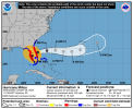
1728530360049.png
 
Back
Top