
Navigation
Install the app
How to install the app on iOS
Follow along with the video below to see how to install our site as a web app on your home screen.
Note: This feature may not be available in some browsers.
More options
-
Welcome to TalkWeather! We see you lurking around TalkWeather! Take the extra step and join us today to view attachments, see less ads and maybe even join the discussion. CLICK TO JOIN TALKWEATHER
You are using an out of date browser. It may not display this or other websites correctly.
You should upgrade or use an alternative browser.
You should upgrade or use an alternative browser.
Hurricane Hurricane Milton
- Thread starter KevinH
- Start date

akt1985
Member
I wonder if this outbreak will beat February 23, 1998 for most tornadoes in Florida in a single day?
You can really tell with historic storms that it would be an exceptionally useful and better measure. I'm in favor of a 10 year or so period where we report both, so folks can get used to the new scale - but it needs to happen, IMO.Using the IKE Calculator (it's an estimate, not exact) from NOAA (https://www.aoml.noaa.gov/hrd/ike/Calculator_AllQuad.php) and roughly estimating the wind fields using the 18z Best Track info and the latest advisory info, the rough estimate for IKE (Integrated Kinetic Energy) for this storm is 116 with a Surge Damage Potential (SDP) of 5.1.
For reference, Katrina had 127 and 5.2. Ian was 48 with 3.7 SDP. Ike had 133 and 5.2 SDP. Charley was 22 and 2.4 SDP. Irma was 80 and 4.5 SDP.
So it looks like an impact a la Katrina is a good analog here. It has similar IKE and similar Surge Damage Potential.
Thanks @Blountwolf for the info on IKE, super interesting!
TornadoFan
Member
Big tornado on the ground near Lakewood Park, FL
cincywx
Member
...A TORNADO WARNING REMAINS IN EFFECT UNTIL 330 PM EDT FOR EAST
CENTRAL COLLIER AND CENTRAL BROWARD COUNTIES...
At 317 PM EDT, a confirmed large and extremely dangerous tornado was
located over Miccosukee Indian Reservation, or 35 miles east of Ave
Maria, moving north at 45 mph.
This is a PARTICULARLY DANGEROUS SITUATION. TAKE COVER NOW!
HAZARD...Damaging tornado.
SOURCE...Radar confirmed tornado.
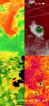
for the cell west of fort lauderdale
SmokeEater
Member
Wasn't there 7 that night? If that's the case this has 100% surpassed that by a few already.I wonder if this outbreak will beat February 23, 1998 for most tornadoes in Florida in a single day?

NEXRAD Mosaic:

A repeating supply of spinning storms of various sizes.
A repeating supply of spinning storms of various sizes.
I imagine the strong shear that is helping to weaken the core of Milton is only helping to exacerbate the tornado situation.
brianc33710
Member
Milton is trying to repair his eyewall.
Yep, the very dry continental air wrapping underneath too - we talk about the storms looking like they are from the plains, well - that's where the air they are mixing came from.I imagine the strong shear that is helping to weaken the core of Milton is only helping to exacerbate the tornado situation.

TornadoFan
Member

TornadoFan
Member
Wow.

TH2002
Member
- Messages
- 4,973
- Reaction score
- 11,113
- Location
- California, United States
- Special Affiliations
- SKYWARN® Volunteer
That's a strong tornado
warneagle
Member
whew that is a deep TDS
TornadoFan
Member
TDS SW of Port St. Lucie?
TornadoFan
Member
Two areas of very strong rotation over Vero Beach.