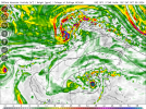
• Welcome to TalkWeather!
    We see you lurking around TalkWeather! Take the extra step and join us today to view attachments, see less ads and maybe even join the discussion.
    CLICK TO JOIN TALKWEATHER

Hurricane Hurricane Milton

Tropical Weather Outlook
NWS National Hurricane Center Miami FL
800 AM EDT Fri Sep 27 2024

For the North Atlantic...Caribbean Sea and the Gulf of Mexico:

2. Western Caribbean:
An area of low pressure could form over the western Caribbean Sea by the middle of next week. Environmental conditions are expected to be conducive for slow development thereafter while the system moves generally northwestward, potentially entering the Gulf of Mexico by the end of next week.
* Formation chance through 48 hours...low...near 0 percent.
* Formation chance through 7 days...low...30 percent.
 
Tropical Weather Outlook
NWS National Hurricane Center Miami FL
800 AM EDT Sat Sep 28 2024

For the North Atlantic...Caribbean Sea and the Gulf of Mexico:

Active Systems:
The National Hurricane Center is issuing advisories on Hurricane Isaac, located several hundred miles east of the Azores, and on Tropical Storm Joyce, located over the central tropical Atlantic Ocean. The Weather Prediction Center is issuing advisories on Post-Tropical Cyclone Helene, located inland over the Ohio River Valley.

2. Western Caribbean Sea and Gulf of Mexico:
An area of low pressure could form over the western Caribbean Sea in a few days. Environmental conditions are expected to be conducive for additional development thereafter while the system moves generally northwestward, and a tropical depression could form during the middle to latter part of next week as the system enters the Gulf of Mexico.

* Formation chance through 48 hours...low...near 0 percent.
* Formation chance through 7 days...medium...40 percent.
 
Tropical Weather Outlook
NWS National Hurricane Center Miami FL
200 PM EDT Sat Sep 28 2024

For the North Atlantic...Caribbean Sea and the Gulf of Mexico:

Active Systems:
The National Hurricane Center is issuing advisories on Hurricane Isaac, located several hundred miles west-northwest of the Azores, and on Tropical Storm Joyce, located over the central Atlantic Ocean. The Weather Prediction Center has issued the last advisory on Post-Tropical Cyclone Helene, located inland over the Ohio River Valley.

2. Western Caribbean Sea and Gulf of Mexico:
An area of low pressure is expected to form over the western Caribbean Sea in a couple of days. Environmental conditions are forecast to be conducive for gradual development thereafter, and a tropical depression could form around the middle part of next week. This system is expected to move northwestward into the Gulf of Mexico during the latter portion of next week, and interests in the northwestern Caribbean Sea and along the U.S. Gulf Coast should monitor its progress.

* Formation chance through 48 hours...low...near 0 percent.
* Formation chance through 7 days...medium...50 percent.
 
GFS is not being subtle. And after Helene... I'm listening.

View attachment 30404
I remember seeing a lot of folks (understandably) writing off modelling about Helene. Euro much less prominent than GFS and GDPS, but a lot of globals sniffing out something in the Gulf around this time frame.
 
I remember seeing a lot of folks (understandably) writing off modelling about Helene. Euro much less prominent than GFS and GDPS, but a lot of globals sniffing out something in the Gulf around this time frame.
The Euro has a hard time this year creating anything intensity-wise. It does show a tropical storm moving into Tampa on the 12z, so I'd take that as a strong enough signal.

What I'm most worried about with this one is the hard-right turn most of the models are beginning to show with it -- I fear many people will write it off as "going to Texas" and then be surprised when it hooks into the Florida Gulf Coast. Careful telegraphing of this will need to be done.
I mean this system's current corridor is almost identical to Helene's. Could go anywhere in the Gulf, including the Panhandle.
 
The Euro has a hard time this year creating anything intensity-wise. It does show a tropical storm moving into Tampa on the 12z, so I'd take that as a strong enough signal.

What I'm most worried about with this one is the hard-right turn most of the models are beginning to show with it -- I fear many people will write it off as "going to Texas" and then be surprised when it hooks into the Florida Gulf Coast. Careful telegraphing of this will need to be done.
Yeah. Euro Operational has been pretty awful this year at picking up anything
 
50% chance of 7-day development this evening.
2. Western Caribbean Sea and Gulf of Mexico:
An area of low pressure is expected to form over the western
Caribbean Sea in a couple of days. Environmental conditions are
forecast to be conducive for gradual development thereafter, and a
tropical depression could form around the middle part of next week.
This system is expected to move northwestward into the Gulf of
Mexico during the latter portion of next week, and interests in the
northwestern Caribbean Sea and along the U.S. Gulf Coast should
monitor its progress.
* Formation chance through 48 hours...low...near 0 percent.
* Formation chance through 7 days...medium...50 percent.
1727571868601.png
 
I'm gonna say probably not much because one Helene was moving fast. Yeah, not much. See this is the problem we have now. While every one was bent out of shape over the nearly 3 weeks of inactivity due to the unfavorable MJO and the "hyperactive" season going up in smokes, the Gulf/Caribbean just stayed very warm and extended the OHC (Oceanic Heat Content) even deeper to a greater ocean depth. I know I'll probably be told I'm wrong about the MJO being the main driver this season, but it has been.
 

Attachments

  • ostia-all-gulf-sst_anom-7395200.png
    ostia-all-gulf-sst_anom-7395200.png
    118.4 KB · Views: 0
Last edited:
Curious to what the models show in the next 24-36 hours. The most recent runs are very iffy on developing anything at all. But it is the western Caribbean during October, so I wouldn't count anything out yet.
 
Back
Top