• Welcome to TalkWeather!
    We see you lurking around TalkWeather! Take the extra step and join us today to view attachments, see less ads and maybe even join the discussion.
    CLICK TO JOIN TALKWEATHER

Hurricane Fiona

Taylor Campbell

Moderator
Moderator
PerryW Project Supporter
Messages
2,102
Reaction score
2,189
Location
Wedowee, AL
Special Affiliations
  1. SKYWARN® Volunteer
Invest 96L in the central Atlantic is headed towards the Leeward Islands and expected to be there by this weekend.
 
  • Thread starter
  • Moderator
  • #2

Taylor Campbell

Moderator
Moderator
PerryW Project Supporter
Messages
2,102
Reaction score
2,189
Location
Wedowee, AL
Special Affiliations
  1. SKYWARN® Volunteer
Invest 96L has been upgraded to Tropical Depression #7.
 
  • Thread starter
  • Moderator
  • #3

Taylor Campbell

Moderator
Moderator
PerryW Project Supporter
Messages
2,102
Reaction score
2,189
Location
Wedowee, AL
Special Affiliations
  1. SKYWARN® Volunteer
Impressive convective blow up tonight. The system is at 1008mb in the most recent update.

goes16-ir-07-L-202209142155.gif
 
  • Thread starter
  • Moderator
  • #4

Taylor Campbell

Moderator
Moderator
PerryW Project Supporter
Messages
2,102
Reaction score
2,189
Location
Wedowee, AL
Special Affiliations
  1. SKYWARN® Volunteer
Tropical Depression #7 has been upgraded to Tropical Storm Fiona. 1002mb at 50mph on the 11PM update.
 

bjdeming

Member
Sustaining Member
Messages
1,512
Reaction score
1,231
Location
Corvallis, Oregon
From Storm Carib earlier today:

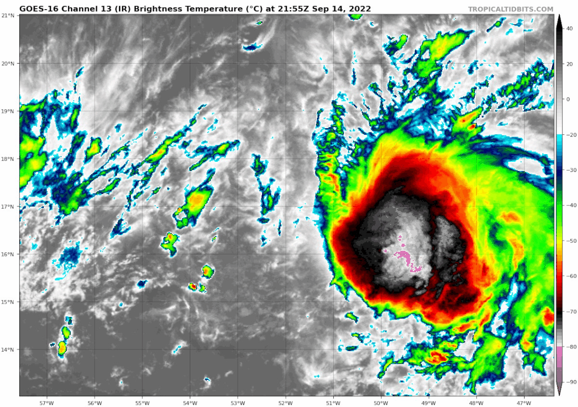
Fiona's low level circulation is far outrunning the large blob of convection behind it, preventing stacking the levels, as moderate wind shear is still inhibiting organization and strengthening. Plus a slug of dry air is leading the way and Fiona is ingesting some of that as well. Good thing or we would probably have a Cat 3 or higher headed our way. For now, those factors should keep Fiona from becoming a hurricane before passage through the islands but we've seen this scenario before. Fiona has been fighting dry air and shear and still plods on slowly consolidating. Wouldn't be surprised if she pulls a meteorological sleight of hand and fools all by making herself a hurricane. Slim odds yes. But......

I don't know. There seem to be a lot of still undecided factors before that can happen plus quite a bit of shear, though the NHC mentions a possibility of circulation stacking several days from now, which could change things if it happens.

If.
 

bjdeming

Member
Sustaining Member
Messages
1,512
Reaction score
1,231
Location
Corvallis, Oregon
I guess this is the Hurricane Fiona thread now?

Per NHC's current discussion, "It appears likely that Fiona will become the first major hurricane of this Atlantic season in a few days."

The Bermuda Weather Service has gotten its page up, though of course there are no updates local threat advisories yet.
 

OHWX97

Member
Messages
1,013
Reaction score
1,425
Location
Maineville, Ohio
Fiona looks to be really gaining steam this afternoon. Once it clears Puerto Rico and Hispaniola, it should easily be able to become a major hurricane, perhaps even a little stronger than what the NHC is currently forecasting.


Significant impacts are ongoing in Puerto Rico, particularly widespread flash flooding, and now Fiona's powerful northeastern eyewall is moving ashore the southern coastline. A weather station located on the coast of the city of Ponce recently measured a wind gust of 103mph! :oops:


Last edited:

warneagle

Member
Messages
3,729
Reaction score
3,208
Location
Arlington, VA
Special Affiliations
  1. SKYWARN® Volunteer
Some parts of Puerto Rico got over two feet of rain yesterday. The highest total I've seen was a hair over 27". It looks like the Dominican Republic is well on its way to similar rain totals as well.
 

bjdeming

Member
Sustaining Member
Messages
1,512
Reaction score
1,231
Location
Corvallis, Oregon
:( And it's moving so slowly and will be all the way to Bermuda (or just west of that island, per current track), taking in the heat. What about shear? Especially right now after this mix-up with Hispaniola. Can that weaken the system?
 

warneagle

Member
Messages
3,729
Reaction score
3,208
Location
Arlington, VA
Special Affiliations
  1. SKYWARN® Volunteer
It doesn't look like the land interaction did too much damage to it structurally and it's going to be moving into an area with relatively weak wind shear and SSTs hovering around 30C, so I don't think it's done much to decrease its ceiling in terms of intensity. Hispaniola can weaken tropical cyclones if a storm travels right over the spine of the island, but Fiona only clipped the eastern third or so of the Dominican Republic and avoided the mountains that usually do the most damage to tropical cyclones. Puerto Rico usually doesn't do as much damage because it's smaller and less mountainous than Hispaniola (the tallest point is like 4500 feet vs. 10000 feet on Hispaniola).
 

warneagle

Member
Messages
3,729
Reaction score
3,208
Location
Arlington, VA
Special Affiliations
  1. SKYWARN® Volunteer
Some more data on the truly absurd rainfall that Fiona dropped on Puerto Rico.


EDIT: this station is located on the Rio Cerrillos, north of Ponce.
 

warneagle

Member
Messages
3,729
Reaction score
3,208
Location
Arlington, VA
Special Affiliations
  1. SKYWARN® Volunteer
up to 105 mph as of the latest advisory, won't be long before it's a major hurricane (if it's not already there)
 

OHWX97

Member
Messages
1,013
Reaction score
1,425
Location
Maineville, Ohio
up to 105 mph as of the latest advisory, won't be long before it's a major hurricane (if it's not already there)
You're right. It didn't take long at all.
BULLETIN
Hurricane Fiona Intermediate Advisory Number 23A
NWS National Hurricane Center Miami FL AL072022
200 AM EDT Tue Sep 20 2022

...FIONA BECOMES A MAJOR HURRICANE AS IT APPROACHES THE TURKS AND
CAICOS ISLANDS...
...HEAVY RAINFALL AND LIFE-THREATENING FLASH FLOODING STILL
OCCURRING IN EASTERN PORTIONS OF THE DOMINICAN REPUBLIC...


SUMMARY OF 200 AM EDT...0600 UTC...INFORMATION
----------------------------------------------
LOCATION...20.9N 70.8W
ABOUT 45 MI...70 KM SSE OF GRAND TURK ISLAND
MAXIMUM SUSTAINED WINDS...115 MPH...185 KM/H
PRESENT MOVEMENT...NNW OR 330 DEGREES AT 10 MPH...17 KM/H
MINIMUM CENTRAL PRESSURE...967 MB...28.56 INCHES
 

Mike S

Administrator
Staff member
Administrator
Moderator
PerryW Project Supporter
Messages
1,991
Reaction score
1,117
Location
Meridianville, Al
Special Affiliations
  1. SKYWARN® Volunteer
Canadian Hurricane warnings aren't something you see every day

BULLETIN
Hurricane Fiona Advisory Number 37
NWS National Hurricane Center Miami FL AL072022
Issued by the NWS Weather Prediction Center College Park MD
1100 AM AST Fri Sep 23 2022

...POWERFUL FIONA STRENGTHENS SLIGHTLY WHILE IT RACES TOWARD
ATLANTIC CANADA...
...HURRICANE CONDITIONS EXPECTED TO BEGIN THERE TONIGHT...


SUMMARY OF 1100 AM AST...1500 UTC...INFORMATION
-----------------------------------------------
LOCATION...35.9N 64.2W
ABOUT 250 MI...405 KM N OF BERMUDA
ABOUT 600 MI...970 KM S OF HALIFAX NOVA SCOTIA
MAXIMUM SUSTAINED WINDS...130 MPH...215 KM/H
PRESENT MOVEMENT...NE OR 45 DEGREES AT 35 MPH...56 KM/H
MINIMUM CENTRAL PRESSURE...936 MB...27.64 INCHES


WATCHES AND WARNINGS
--------------------
CHANGES WITH THIS ADVISORY:

None.

SUMMARY OF WATCHES AND WARNINGS IN EFFECT:

A Hurricane Warning is in effect for...
* Nova Scotia from Hubbards to Brule
* Prince Edward Island
* Isle-de-la-Madeleine
* Newfoundland from Parson's Pond to Francois


A Tropical Storm Warning is in effect for...
* Bermuda
* St. Andrews New Brunswick to west of Hubbards Nova Scotia
* West of Brule Nova Scotia to Cap Madeleine Quebec
* Anticosti Island
* Sheldrake Quebec to north of Parson's Pond Newfoundland
* Boat Harbor to Hare Bay Newfoundland
* Francois to St Lawrence Newfoundland

A Tropical Storm Watch is in effect for...
* North of Boat Harbor Newfoundland to West Bay Labrador
 
  • Thread starter
  • Moderator
  • #19

Taylor Campbell

Moderator
Moderator
PerryW Project Supporter
Messages
2,102
Reaction score
2,189
Location
Wedowee, AL
Special Affiliations
  1. SKYWARN® Volunteer
This is a 125mph wind storm moving at 46mph!
 

Mike S

Administrator
Staff member
Administrator
Moderator
PerryW Project Supporter
Messages
1,991
Reaction score
1,117
Location
Meridianville, Al
Special Affiliations
  1. SKYWARN® Volunteer
Josh Morgerman is chasing it in Canada after penetrating its eyewall in the Dominican Republic earlier in the week
 
Logo 468x120
Back
Top