notsoencrypted
Member
Yeah, the current rainfall forecast is quite worrying.

I've heard that the area is already fairly saturated? That's really worrying.
I've heard that the area is already fairly saturated? That's really worrying.
Follow along with the video below to see how to install our site as a web app on your home screen.
Note: This feature may not be available in some browsers.

It's also highly vulnerable to storm surge, even a mild but persistent surge could be a major threat to the many islands that lie along the South Atlantic Bight, most of which are very flat.Yeah, the current rainfall forecast is quite worrying.
View attachment 29551
I've heard that the area is already fairly saturated? That's really worrying.
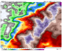
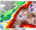
Yeah. I'm concerned some locations could see near 40 inches or more within a weeks time. The 12z Canadian and 00z Euro total rainfall amounts are really underdone.If I lived in the peninsula up to NE FL, SW GA, or S SC, I'd be building an Ark. Being able to feed off the gulf and the Atlantic, Debby is going to be stubbornly persistent and slow moving. I think it's possible we'll still be talking about her next weekend.


Yeah, there's not much in the way of grounds for certainty at this time, I don't think. Anything from a stall over land, a meander along the South Atlantic Bight or a transit up the East Coast seems possible, but very difficult to make much of an assessment right now. In any case, the areal coverage of impacts will be large.The models are still struggling what to do with Debby after her inevitable landfall. (This is a semi-repeat of a post I made yesterday, but with the latest info.)
At Day 3 (8 AM EDT Wednesday), over 1/3 of the GEFS members still have Debby in Florida or just offshore in Florida. Basically the same on Day 4 (Thursday). By Day 5, many are retrograding over Alabama and Georgia, but still haven't made much progress. By Day 7 (a full week from now), 1/3 of the members are less than 500 miles from landfall location (forecasted). In fact, 3 of the members (about 10%) are back over the open waters of the Gulf.
At this point, I am NOT settling on the notion that it stalls off the Georgia/Carolina coast -- there's just too much variability in the model runs.
View attachment 29561
View attachment 29562
View attachment 29563
View attachment 29564

Here in St. Pete (I moved from Tallahassee recently to take a new job!), it is howling outside, the roughest band yet! But I think it's about as close approach as it'll be here.Debby trying to hurricane soon. Based on radar and satellite, it shouldn't be long
Congrats!Here in St. Pete (I moved from Tallahassee recently to take a new job!), it is howling outside, the roughest band yet! But I think it's about as close approach as it'll be here.
Tropical Storm Debby Local Statement Advisory Number 10
GAZ086-096>098-105>113-050515-
Tropical Storm Debby Local Statement Advisory Number 10
National Weather Service Peachtree City GA AL042024
515 PM EDT Sun Aug 4 2024
This product covers NORTH AND CENTRAL GEORGIA
**Potentially Historic Rainfall Anticipated with Tropical Storm Debby
Monday into Tuesday**
NEW INFORMATION
---------------
* CHANGES TO WATCHES AND WARNINGS:
- The Tropical Storm Watch has been upgraded to a Tropical Storm
Warning for Dodge, Montgomery, Telfair, Toombs, Wheeler, and
Wilcox
- A Tropical Storm Watch has been issued for Bleckley, Dooly,
Emanuel, Laurens, Pulaski, and Treutlen
* CURRENT WATCHES AND WARNINGS:
- A Tropical Storm Warning is in effect for Dodge, Montgomery,
Telfair, Toombs, Wheeler, and Wilcox
- A Tropical Storm Watch is in effect for Bleckley, Crisp, Dooly,
Emanuel, Laurens, Pulaski, and Treutlen
* STORM INFORMATION:
- About 300 miles south of Cordele GA or about 330 miles
south-southwest of Vidalia GA
- 27.7N 84.4W
- Storm Intensity 65 mph
- Movement North or 360 degrees at 12 mph
SITUATION OVERVIEW
------------------
OVERVIEW...
Tropical Storm Debby is expected to make landfall on Monday in the Big
Bend Region of Florida along the Apalachee Bay and track into southern
Georgia on Tuesday. Potentially historic heavy rainfall will likely
result in considerable flooding impacts across portions of east
central Georgia. Current forecast amounts through Wednesday morning
are 7-10" along a line of counties from Jefferson to Wilcox and points
southeast, with amounts of 13+" possible in some locations. Rainfall
of these amounts will lead to widespread, significant flash flooding.
Significant flooding of creeks, streams, and rivers is also expected.
A Tropical Storm warning is in effect for SE Georgia for tropical
storm force winds that are expected to begin on Monday with the
strongest winds expected from Crisp to Toombs county. A Tropical Storm
Watch from Emanuel to Dooly to account for uncertainty in northward
progression of winds. Sustained winds of 40-45 mph will be possible,
with some higher gusts.
The tornado threat remains low, but an isolated tornado is possible
mainly south of a line from Uvalda to Milan.
POTENTIAL IMPACTS
-----------------
* FLOODING RAIN:
Protect against life-threatening rainfall flooding having possible
devastating impacts across east central Georgia. Potential impacts
include:
- Extreme rainfall flooding may prompt numerous evacuations and
rescues.
- Rivers and tributaries may overwhelmingly overflow their banks
in many places with deep moving water. Small streams, creeks,
canals, arroyos, and ditches may become raging rivers. In
mountain areas, deadly runoff may rage down valleys while
increasing susceptibility to rockslides and mudslides. Flood
control systems and barriers may become stressed.
- Flood waters can enter numerous structures within multiple
communities, some structures becoming uninhabitable or washed
away. Numerous places where flood waters may cover escape
routes. Streets and parking lots become rivers of raging water
with underpasses submerged. Driving conditions become very
dangerous. Numerous road and bridge closures with some weakened
or washed out.
Protect against life-threatening rainfall flooding having possible
limited to extensive impacts across east central Georgia.
* WIND:
Protect against dangerous wind having possible significant impacts
across east central Georgia. Potential impacts in this area include:
- Some damage to roofing and siding materials, along with damage
to porches, awnings, carports, and sheds. A few buildings
experiencing window, door, and garage door failures. Mobile
homes damaged, especially if unanchored. Unsecured lightweight
objects become dangerous projectiles.
- Several large trees snapped or uprooted, but with greater
numbers in places where trees are shallow rooted. Several
fences and roadway signs blown over.
- Some roads impassable from large debris, and more within urban
or heavily wooded places. A few bridges, causeways, and access
routes impassable.
- Scattered power and communications outages, but more prevalent
in areas with above ground lines.
Also, protect against hazardous wind having possible limited impacts
across east central Georgia.
Elsewhere across NORTH AND CENTRAL GEORGIA, little to no impact is
anticipated.
* TORNADOES:
Protect against a tornado event having possible limited impacts across
east central Georgia. Potential impacts include:
- The occurrence of isolated tornadoes can hinder the execution
of emergency plans during tropical events.
- A few places may experience tornado damage, along with power
and communications disruptions.
- Locations could realize roofs peeled off buildings, chimneys
toppled, mobile homes pushed off foundations or overturned,
large tree tops and branches snapped off, shallow-rooted trees
knocked over, moving vehicles blown off roads, and small boats
pulled from moorings.
Elsewhere across NORTH AND CENTRAL GEORGIA, little to no impact is
anticipated.
PRECAUTIONARY/PREPAREDNESS ACTIONS
----------------------------------
* EVACUATIONS:
Follow the advice of local and state officials.
* OTHER PREPAREDNESS INFORMATION:
Now is the time to complete all preparations to protect life and
property in accordance with your emergency plan. Ensure you are in a
safe location before the onset of strong winds or possible flooding.
Keep cell phones well charged. Cell phone chargers for automobiles
can be helpful, but be aware of your risk for deadly carbon monoxide
poisoning if your car is left idling in a garage or other poorly
ventilated area.
Rapidly rising flood waters are deadly. If you are in a flood-prone
area, consider moving to higher ground. Never drive through a flooded
roadway. Remember, turn around don`t drown!
If a Tornado Warning is issued for your area, be ready to shelter
quickly, preferably away from windows and in an interior room not
prone to flooding. If driving, scan the roadside for quick shelter
options.
Closely monitor weather.gov, NOAA Weather radio or local news outlets
for official storm information. Be ready to adapt to possible changes
to the forecast. Ensure you have multiple ways to receive weather
warnings.
* ADDITIONAL SOURCES OF INFORMATION:
- For information on creating an emergency plan see ready.ga.gov
- For information on appropriate preparations see ready.gov
- For additional disaster preparedness information see redcross.org
NEXT UPDATE
-----------
The next local statement will be issued by the National Weather
Service in Peachtree City GA around 1115 PM EDT, or sooner if
conditions warrant.
$$