
Navigation
Install the app
How to install the app on iOS
Follow along with the video below to see how to install our site as a web app on your home screen.
Note: This feature may not be available in some browsers.
More options
-
Welcome to TalkWeather! We see you lurking around TalkWeather! Take the extra step and join us today to view attachments, see less ads and maybe even join the discussion. CLICK TO JOIN TALKWEATHER
You are using an out of date browser. It may not display this or other websites correctly.
You should upgrade or use an alternative browser.
You should upgrade or use an alternative browser.
wx_guy
Member
- Messages
- 1,237
- Reaction score
- 4,443
- Location
- United States
- HAM Callsign
- KO4ZGH
- Special Affiliations
- SKYWARN® Volunteer
- ARRL Member
Let's go Debby! Okay, maybe not...actually have a bad feeling about her lol

slenker
Member
What’s the SHIPS guidance looking like? Any good chance of RI for this system?
wx_guy
Member
- Messages
- 1,237
- Reaction score
- 4,443
- Location
- United States
- HAM Callsign
- KO4ZGH
- Special Affiliations
- SKYWARN® Volunteer
- ARRL Member

Indeed, growing chances of Rapid Intensification. EDIT: The 25% chance of 65 knots in 72 hours is scaring me -- that's enough to make it a Cat 2/3...really hoping that's overblown.
- Thread starter
- #6
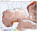
Well, when I see these SST values with max in the Eastern Gulf of 32.8 C (92 F), you kinda expect a major and RI. Of course, they're playing the wind shear and dry air might limit card. Yeah we saw how that led to Beryl significantly weakening during it's trek across the Caribbean. Shear is 5 to 10 kts at most over the Gulf and there's hardly any dust (dry air). IDK about everyone else, but it seems the talk about shear/dry air this season has been overblown.
Attachments

wx_guy
Member
- Messages
- 1,237
- Reaction score
- 4,443
- Location
- United States
- HAM Callsign
- KO4ZGH
- Special Affiliations
- SKYWARN® Volunteer
- ARRL Member
I'm gonna call this now...call me crazy, but I say a 115 mph Cat 3 at landfall. Hope I eat those words.Well, when I see these SST values with max in the Eastern Gulf of 32.8 C (92 F), you kinda expect a major and RI. Of course, they're playing the wind shear and dry air might limit card. Yeah we saw how that led to Beryl significantly weakening during it's trek across the Caribbean. Shear is 5 to 10 kts at most over the Gulf and there's hardly any dust (dry air). IDK about everyone else, but it seems the talk about shear/dry air this season has been overblown.
I'm gonna call this now...call me crazy, but I say a 115 mph Cat 3 at landfall. Hope I eat those words.
Maybe give it another 6 hours lol.
wx_guy
Member
- Messages
- 1,237
- Reaction score
- 4,443
- Location
- United States
- HAM Callsign
- KO4ZGH
- Special Affiliations
- SKYWARN® Volunteer
- ARRL Member
You're right, of course. I've been an amateur hurricane tracker for 25+ years, and I just get "feelings" haha...but of course, the data will say what the data says, feelings be damned lol so 6 more hours is a smart play probablyMaybe give it another 6 hours lol.
slenker
Member
With what we have now, a high end C1 at landfall seems pretty likely to me. Based on my very amateur opinion, lolYou're right, of course. I've been an amateur hurricane tracker for 25+ years, and I just get "feelings" haha...but of course, the data will say what the data says, feelings be damned lol so 6 more hours is a smart play probably
I think the more concerning thing about this system is the rainfall potential.
jiharris0220
Member
After what happened with Otis I wouldn’t be surprised about at least a major making landfall. Do I think it’s going to happen?
No, but I wouldn’t be surprised considering the only limiting factor is Debby’s broad nature and limited time over water.
No, but I wouldn’t be surprised considering the only limiting factor is Debby’s broad nature and limited time over water.
If the track holds, I think the intensity forecast will be closer to verifying. The deep heat is to the west. A track shift toward the central gulf would spell a big problem. SSTs are hot though, so if it moves fast enough to avoid a lot of upwelling, I still wouldn't be surprised to see more strengthening than expected.

wx_guy
Member
- Messages
- 1,237
- Reaction score
- 4,443
- Location
- United States
- HAM Callsign
- KO4ZGH
- Special Affiliations
- SKYWARN® Volunteer
- ARRL Member
0Z Ships now *explicitly forecasting Rapid Intensification*....56% chance to bring it to a 75 mph Hurricane in the next 24 hours, and a whopping 41% to bring it to a Cat 3 hurricane.
Getting sPiCy!

Getting sPiCy!
wx_guy
Member
- Messages
- 1,237
- Reaction score
- 4,443
- Location
- United States
- HAM Callsign
- KO4ZGH
- Special Affiliations
- SKYWARN® Volunteer
- ARRL Member
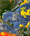
Want to see crazy????? So I have a plot in Python that shows GEFS Ensemble Member sustained winds (using troPYcal). I took off the line plots of the wind strength because it was so messy, just so we could see where the 31 members lie. After FIVE days, where do the members lie? 50% of them are still in flipping Florida! This is Thursday!! On day 6, more than half of the members are either in Florida, Georgia, or Alabama. And after a full week (next Saturday), about 1/3 of the members have retrograded further west, and over half of the members are still surviving in the Southeast.
If the GEFS is onto anything, this storm is going to be with us a long while, and the rain is going to be catastrophic.


If the GEFS is onto anything, this storm is going to be with us a long while, and the rain is going to be catastrophic.
Want to see crazy????? So I have a plot in Python that shows GEFS Ensemble Member sustained winds (using troPYcal). I took off the line plots of the wind strength because it was so messy, just so we could see where the 31 members lie. After FIVE days, where do the members lie? 50% of them are still in flipping Florida! This is Thursday!! On day 6, more than half of the members are either in Florida, Georgia, or Alabama. And after a full week (next Saturday), about 1/3 of the members have retrograded further west, and over half of the members are still surviving in the Southeast.
If the GEFS is onto anything, this storm is going to be with us a long while, and the rain is going to be catastrophic.
Debby does donuts.

- Thread starter
- #17
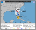
From my Patreon Post: Debby is expected to intensify into an 85mph category 1 hurricane by Monday morning prior to landfall on the Northwest Florida coastline (roughly just east of Tallahassee). It is expected to either stall out or move very slowly across southern Georgia then making it's way offshore of the Georgia coast by late Wednesday/early Thursday before making a final landfall on the South Carolina coast by late week. It should be noted that this entire forecast track is not set in stone and that folks across northern Florida to South Carolina should prepare for major/catastrophic flash flooding. Also, Debby (while not explicitly forecasted at present time) has high potential to rapidly intensify into a major hurricane (category 3 to 5) prior to landfall on the Florida coast. In fact, the SHIPS model is showing a 56% chance of a 25kt wind increase within the next 24 hours, a 39% chance of a 30kt wind increase within the next 24 hours, a 38% chance of a 45kt increase within the next 36 hours, a 48% chance of a 55kt increase within the next 48 hours, and a 41% chance of seeing a 65kt increase within the next 72 hours. These are all pretty high odds.
wx_guy
Member
- Messages
- 1,237
- Reaction score
- 4,443
- Location
- United States
- HAM Callsign
- KO4ZGH
- Special Affiliations
- SKYWARN® Volunteer
- ARRL Member
06z SHIPS still strong chances of Rapid Intensification. The HAFS-B explicitly shows this on the 0z run, bringing Debby up to 115 mph before landfall.

wx_guy
Member
- Messages
- 1,237
- Reaction score
- 4,443
- Location
- United States
- HAM Callsign
- KO4ZGH
- Special Affiliations
- SKYWARN® Volunteer
- ARRL Member
Up to 60 mph at 8 AM Advisory.