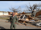
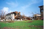
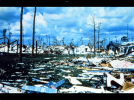
I need to remember to come here more often during tropical weather instead of just severe weather lmao, tree damage in hurricanes is definitely a thing I have spent some time researching. I posted a
now very outdated thread with many now-dead links on S2K several years ago comparing a ton of historical violent landfalls around the world. Some conclusions:
- A storm undergoing rapid strengthening causes far more violent tree damage than a weakening one of the same intensity (much higher gusts)
- Even a little elevation can bring in some insane gusts, with trees obliterated on hills in high end storms
- Tree species composition matters a lot at lower categories, but above the 145-150kt threshold, matters very little
- Some historical hurricane landfall intensities may be a good bit stronger or weaker than officially estimated based on consistency of tree damage vs. intensity
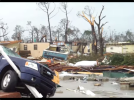
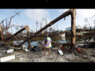
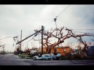
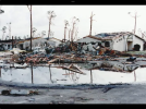
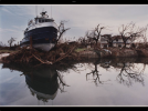
I hadn't seen those vegetation damage pics; that sort of shredded, lifeless vegetation obliteration is hard to get below 150kt, or at least 145kt. Forests of St Vincent and the Grenadines are composed of rainforest, some dry scrub forests, and at least some surviving coastal mangroves, in the Windwards Islands ecoregion comprised of both a lot of endemics and South American species. That of course is dramatically different than the forests of US/Cuba/Bahamas where you'll be dealing with slash pine or other subtropical pines, but the threshold where this starts making a difference is in the 120kt range or so. Notably, the southern Windwards have very few historical hurricanes on record to compare to of that intensity. Ivan is really the only comparable case for the southern Grenadines and Grenada, passing through as a 110kt storm on a strengthening trend. Ivan, on a strengthening trend, actually caused some really impressive tree damage for a category three storm; I'd argue it probably produced category four winds as vegetation on hills was shredded very effectively to category four typical levels in Grenada...
View attachment 29313
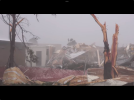
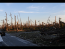
... however, on the other 110kt landfall in AL during a weakening trend, tree damage was not very impressive at all. Lots of uprooting, a bunch of snapped pines but not as whole forests, just here and there. Clearly storms intensifying with very strong surface winds and gusts (which we see in SFMR vs flight level profiles in intensifying storms!) do a lot more tree damage. Beryl was definitely extremely intense and RI'ing as it moved through, and I'd bet surface gusts were extremely strong before mixing settled in. We had the 197kt sonde not too far off the surface (906mb level) the following morning, so I would not at all be shocked if there were extreme 150+kt wind gusts on that elevated terrain where the forests were shredded during the RI periods, which of course SFMRs were not working very well for. Forward speed is definitely a factor too. Fast moving very intense storm rapidly intensifying with the RFQ moving onto a mountainous island = perfect recipe for extreme tree damage