
Navigation
Install the app
How to install the app on iOS
Follow along with the video below to see how to install our site as a web app on your home screen.
Note: This feature may not be available in some browsers.
More options
-
Welcome to TalkWeather! We see you lurking around TalkWeather! Take the extra step and join us today to view attachments, see less ads and maybe even join the discussion. CLICK TO JOIN TALKWEATHER
You are using an out of date browser. It may not display this or other websites correctly.
You should upgrade or use an alternative browser.
You should upgrade or use an alternative browser.
Hurricane Hurricane Beryl
- Thread starter Casuarina Head
- Start date

I always love the true color shots of tropical cyclones late in the day with the long shadows.

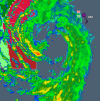
Beryl is getting a little spicy out there as we head to bed - not a lot of time left to do much strengthening, but she's going to give it a shot. I dislike storms that are strengthening at landfall - they always seem to get up to more mischief. Also seems to me like she's still wanting to be to the right of guidance. Houston is going to have an interesting morning.


TornadoFan
Member
Beryl is officially a hurricane again.
TornadoFan
Member
Hurricane Beryl Tropical Cyclone Update
NWS National Hurricane Center Miami FL AL022024
1100 PM CDT Sun Jul 7 2024
...BERYL IS AGAIN A HURRICANE...
Data from the National Weather Service Doppler radar near Houston,
Texas, and reports from an Air Force Reserve Hurricane Hunter
aircraft indicate that Beryl's maximum sustained winds have
increased to near 75 mph (120 km/h). Based on these data, Beryl is
upgraded to a hurricane. Additional strengthening is expected
before landfall on the Texas coast.
NOAA buoy 42019 recently reported sustained winds of 60 mph
(97 km/h) and a wind gust of 74 mph (119 km/h). The buoy also
reported a pressure of 992.2 mb (29.30 inches).
akt1985
Member
Beryl made landfall just after 3 AM Central as a Category 1 Hurricane
Beryl is still a hurricane, 5 hours later. Honestly looks better right now than most of its trip across the gulf. That won't last much longer though. As expected, it's been a rough morning in Houston. Lots of folks without power (1m+), lots of tree debris and flying trampolines, and lots of trees coming down. At least one person has been killed when a tree fell on their house.

Now a tropical storm. Winds down to 70.
jiharris0220
Member
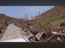
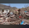
Honestly I’m surprised on how many reinforced concrete buildings were destroyed in Carriacou, here’s a two story house made of the material, the second floor was obliterated and the first floor was gutted to oblivion.
Also, notice the low lying shrub on the lower right side, it’s completely denuded, that takes extreme surface winds to achieve especially in a hurricane.
I’ve seen ef4 tornadoes leave shrubs with their leaves, what makes it even more impressive is that beryl was moving at 22mph, which is fast by Hurricane standards.
jiharris0220
Member
Here’s the link to the video this photo was taken from.
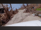
According to the individuals here, 32 wooden structures are gone, as in slabbed kind of gone.
11 reinforced concrete structures like the school Brandon showed earlier and this house are destroyed.
Out of the 89 damaged houses on the island, 69 of those straight up don’t have roofs.
According to the individuals here, 32 wooden structures are gone, as in slabbed kind of gone.
11 reinforced concrete structures like the school Brandon showed earlier and this house are destroyed.
Out of the 89 damaged houses on the island, 69 of those straight up don’t have roofs.
Still tons of power outages in Houston after Beryl.
locomusic01
Member
Major power problems persist in Houston. 460,000 customers without power, which is likely easily >1 million persons. In the midst of summer heat, this is a serious problem, especially for the unhoused, the elderly and the disabled.
Man, that's brutal. We lost power for a little over a week here in PA after Irene in 2011 and it was miserable - I can't even imagine having to deal with Houston's heat and humidity on top of that. Sure hope they do get most customers restored by tonight/tomorrow. I suppose one positive is that people are less likely to use portable generators in enclosed areas, which often happens in cold/snowy weather.
Sawmaster
Member
Major power problems persist in Houston. 460,000 customers without power, which is likely easily >1 million persons. In the midst of summer heat, this is a serious problem, especially for the unhoused, the elderly and the disabled.
I've lived in many places, and having lived in Houston during a summer while working outdoors I can tell you that it's the closest to hell on earth that I've ever experienced. At 6AM local it's 90F+ and 90%+ humidity and then it gets worse from there. I was young used to working outside in summers but that was almost more than I could take. It would likely kill me to try it now.
Yeah, I've heard a few folks say the Houston heat is just something else. Can't imagine trying to do it without any power right now.I've lived in many places, and having lived in Houston during a summer while working outdoors I can tell you that it's the closest to hell on earth that I've ever experienced. At 6AM local it's 90F+ and 90%+ humidity and then it gets worse from there. I was young used to working outside in summers but that was almost more than I could take. It would likely kill me to try it now.
jiharris0220
Member
After looking over at everything regarding wind damage in the windward islands, I can confidently say cat5 winds, (even high end) occurred in Carriacou, Petite Martinique, and especially Union Island.
I’ll go as far to say it was just as bad in Irma, even though there’s no evidence that Beryl was a cat5 at landfall. Although this can easily be explained by the mountains in which the infrastructure is built on.
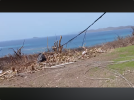
Without further a do, here’s the physical evidence, with vegetation. In the first photo, all vegetation has been 100% denuded, regardless of the type, even the palm trees were reduced to match sticks.
In the second photo, you can even see moderate debarking on some of the use to be trees. Especially the third photo, the vegetation has that classic “bleached/burned” look, a phenomena that I’ve seen exclusive to only high end cat5 winds.
The fourth photo is the most impressive to me, as the damage here to vegetation is something I haven’t seen in many ef4 rated tornadoes. Just a slew of granulated pieces of debarked branches and trees that look like they went through a nuclear blast.
The last photo more or less shows the same thing, and that even trees with large trunks and branches were no match whatsoever.
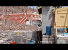
I’ve already shown you guys the structural damage in earlier photos, mainly with the surprising amount of reinforced concrete buildings destroyed.
I’m telling you, there are way, waaay more, to the point that I’ve haven’t seen so many destroyed since Irma and even Haiyan. There’s so many of these destroyed structures it’s pointless to show all of them.
It’s to the point where the only explanation I can think of is that this storm must of had unusually high gust even for its strength, well into the 200mph range. Which is a phenomenon that can occur in rapidly strengthening hurricanes combined with mountainous terrain.
Which is the only explanation that makes sense other than saying that Beryl was a straight up 160knot storm. Because not even Maria in Dominic and Puerto Rico did anything like this despite supposedly being the stronger storm.
Finally, the death toll for beryl in the windward islands is 17, with one missing, all wind related fatalities involving people dying from flying debris and being crushed by heavy concrete walls that they thought should’ve protected them.
It’s very rare for a hurricane to get about 10 fatalities directly from wind, and if it does happen the explanation is shoddy construction. Obviously, this isn’t one of those situations where the structures failed because they were weak, but a situation where the structures failed because the hurricane was unfortunately just that strong.
I’ll go as far to say it was just as bad in Irma, even though there’s no evidence that Beryl was a cat5 at landfall. Although this can easily be explained by the mountains in which the infrastructure is built on.
Without further a do, here’s the physical evidence, with vegetation. In the first photo, all vegetation has been 100% denuded, regardless of the type, even the palm trees were reduced to match sticks.
In the second photo, you can even see moderate debarking on some of the use to be trees. Especially the third photo, the vegetation has that classic “bleached/burned” look, a phenomena that I’ve seen exclusive to only high end cat5 winds.
The fourth photo is the most impressive to me, as the damage here to vegetation is something I haven’t seen in many ef4 rated tornadoes. Just a slew of granulated pieces of debarked branches and trees that look like they went through a nuclear blast.
The last photo more or less shows the same thing, and that even trees with large trunks and branches were no match whatsoever.
I’ve already shown you guys the structural damage in earlier photos, mainly with the surprising amount of reinforced concrete buildings destroyed.
I’m telling you, there are way, waaay more, to the point that I’ve haven’t seen so many destroyed since Irma and even Haiyan. There’s so many of these destroyed structures it’s pointless to show all of them.
It’s to the point where the only explanation I can think of is that this storm must of had unusually high gust even for its strength, well into the 200mph range. Which is a phenomenon that can occur in rapidly strengthening hurricanes combined with mountainous terrain.
Which is the only explanation that makes sense other than saying that Beryl was a straight up 160knot storm. Because not even Maria in Dominic and Puerto Rico did anything like this despite supposedly being the stronger storm.
Finally, the death toll for beryl in the windward islands is 17, with one missing, all wind related fatalities involving people dying from flying debris and being crushed by heavy concrete walls that they thought should’ve protected them.
It’s very rare for a hurricane to get about 10 fatalities directly from wind, and if it does happen the explanation is shoddy construction. Obviously, this isn’t one of those situations where the structures failed because they were weak, but a situation where the structures failed because the hurricane was unfortunately just that strong.
Attachments
Last edited:
slenker
Member
Carriacou was also in the northern eyewall, where the winds would have been stronger than in the southern eyewall. That damage is really intense though; Beryl’s central pressure in the high 930’s at the point of impact on Carriacou, so I’m still a little confused as to why the intensity of the winds was so comparable to high end C5’s with pressures below 910 mb.After looking over at everything regarding wind damage in the windward islands, I can confidently say cat5 winds, (even high end) occurred in Carriacou, Petite Martinique, and especially Union Island.
I’ll go as far to say it was just as bad in Irma, even though there’s no evidence that Beryl was a cat5 at landfall. Although this can easily be explained by the mountains in which the infrastructure is built on.
Without further a do, here’s the physical evidence, with vegetation. In the first photo, all vegetation has been 100% denuded, regardless of the type, even the palm trees were reduced to match sticks.
In the second photo, you can even see moderate debarking on some of the use to be trees. Especially the third photo, the vegetation has that classic “bleached/burned” look, a phenomena that I’ve seen exclusive to only high end cat5 winds.
The fourth photo is the most impressive to me, as the damage here to vegetation is something I haven’t seen in many ef4 rated tornadoes. Just a slew of granulated pieces of debarked branches and trees that look like they went through a nuclear blast.
The last photo more or less shows the same thing, and that even trees with large trunks and branches were no match whatsoever.
I’ve already shown you guys the structural damage in earlier photos, mainly with the surprising amount of reinforced concrete buildings destroyed.
I’m telling you, there are way, waaay more, to the point that I’ve haven’t seen so many destroyed since Irma and even Haiyan. There’s so many of these destroyed structures it’s pointless to show all of them.
It’s to the point where the only explanation I can think of is that this storm must of had unusually high gust even for its strength, well into the 200mph range. Which is a phenomenon that can occur in rapidly strengthening hurricanes combined with mountainous terrain.
Which is the only explanation that makes sense other than saying that Beryl was a straight up 160knot storm. Because not even Maria in Dominic and Puerto Rico did anything like this despite supposedly being the stronger storm.
jiharris0220
Member
The pressure can be explained by small size and background sea level pressures. Smaller storms have much tighter pressure gradients, especially if they’re being superimposed on by a ridge.Carriacou was also in the northern eyewall, where the winds would have been stronger than in the southern eyewall. That damage is really intense though; Beryl’s central pressure in the high 930’s at the point of impact on Carriacou, so I’m still a little confused as to why the intensity of the winds was so comparable to high end C5’s with pressures below 910 mb.
What’s puzzling is how did such stupidly extreme damage occur when similarly strong storms like Maria or Otis, both storms that struck mountainous terrain as Cat 4/5 storms did not.
I can only assume beryl had unusually strong and persistent wind gust for its strength, it was moving at 22mph which probably gave its northern eyewall even more of a boost in the form of wind gust.