Finally got a chance to take a better look at these pics on a bigger screen, and I gotta say I'm absolutely blown away This is the perfect example of houses that weren't just blown over. The lack of debris anywhere in sight tells me the houses were lifted whole and tossed long distances. Every contextual indicator you could possibly ask for is present too.
I see insane ground scouring and entirely stripped trees (on the ground) here:
View attachment 37265
Does anyone know where this pic was taken? It looks like it could be from one of the fields directly adjacent to this neighborhood.
View attachment 37268
I see possible evidence of trenching here:
View attachment 37266
That evidence is further supported from this alternate angle, where you can see the ripped up clumps of dirt on the driveway.
View attachment 37267
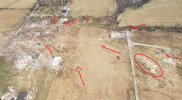
I'm not even sure where this house (circled) came from! I drew arrows next to contextuals that indicate wind direction as the tornado passed over and they aren't saying the debris is from the slab directly above:
View attachment 37270
Here's another angle... There are no other houses in sight. This indicates large chunks of this home were carried a half mile or more. The smaller circle up top could be our trenching. The tree lines in the distance of both photos appear to match, but no way to say for sure. I'll look in the DAT and see if I can find anything.
View attachment 37271
I've seen a lot of tornado damage photos over the last 20 years, and I gotta say, this is the most impressive damage I've ever seen in my life. I'm dumbfounded it wasn't rated EF5. From my seat, it looks like the homes that were anchored were severely granulated and wind-rowed, and the houses without anchors are literally just gone. No trace. They're in the Land of Oz.