- Moderator
- #201
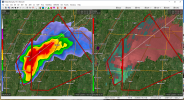
Amagon, AR may soon get a direct hit from a tornado and no warning that a confirmed tornado is headed their way.
Follow along with the video below to see how to install our site as a web app on your home screen.
Note: This feature may not be available in some browsers.
Yeah, I noticed that too. Multiple spotters have reported it, not sure why it's not described as confirmed.There was a report of a tornado on the ground and the warning doesn’t include the confirmed tornado wording.
Make that four...Up to three warnings up in Missouri

But on a path towards Jonesboro.Amagon missed direct hit. Tornado remaining over very rural area.
Less than 20 miles away.But on a path towards Jonesboro.
Warning extended to include Jonesboro. NWS still says radar indicated.
809
WWUS53 KLSX 110035
SVSLSX
Severe Weather Statement
National Weather Service St Louis MO
635 PM CST Fri Dec 10 2021
MOC007-027-110115-
/O.CON.KLSX.TO.W.0038.000000T0000Z-211211T0115Z/
Audrain MO-Callaway MO-
635 PM CST Fri Dec 10 2021
...A TORNADO WARNING REMAINS IN EFFECT UNTIL 715 PM CST FOR SOUTH
CENTRAL AUDRAIN AND NORTHEASTERN CALLAWAY COUNTIES...
At 634 PM CST, a severe thunderstorm capable of producing a tornado
was located near Auxvasse, moving northeast at 80 mph.
HAZARD...Tornado.
SOURCE...Radar indicated rotation.
IMPACT...Flying debris will be dangerous to those caught without
shelter. Mobile homes will be damaged or destroyed. Damage
to roofs, windows, and vehicles will occur. Tree damage is
likely.
This dangerous storm will be near...
Martinsburg and Shamrock around 645 PM CST.
This includes Interstate 70 in Missouri between exits 144 and 161.
PRECAUTIONARY/PREPAREDNESS ACTIONS...
TAKE COVER NOW! Move to a basement or an interior room on the lowest
floor of a sturdy building. Avoid windows. If you are outdoors, in a
mobile home, or in a vehicle, move to the closest substantial shelter
and protect yourself from flying debris.
Tornadoes are extremely difficult to see and confirm at night. Do not
wait to see or hear the tornado. TAKE COVER NOW!
&&
LAT...LON 3901 9205 3924 9163 3887 9164 3877 9207
TIME...MOT...LOC 0034Z 237DEG 69KT 3897 9190
TORNADO...RADAR INDICATED
MAX HAIL SIZE...<.75 IN
$$
Britt

Lots of interference on LZK's radar particularly in Velocity mode.