
Navigation
Install the app
How to install the app on iOS
Follow along with the video below to see how to install our site as a web app on your home screen.
Note: This feature may not be available in some browsers.
More options
-
Welcome to TalkWeather! We see you lurking around TalkWeather! Take the extra step and join us today to view attachments, see less ads and maybe even join the discussion. CLICK TO JOIN TALKWEATHER
You are using an out of date browser. It may not display this or other websites correctly.
You should upgrade or use an alternative browser.
You should upgrade or use an alternative browser.
Severe WX April 3-6 Severe weather
- Thread starter UncleJuJu98
- Start date
Kolle
Member
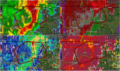
BWER on radar. It's crossing the river just south of the Killen area.

Kolle
Member
cheestaysfly
Member
Well I've been having an extremely fun time here in downtown Florence! That was entirely too close for comfort. We're still in the shelter.
Jpgood97
Member
Looks like a cc drop south of Lester, AL. Would head towards Ardmore
Looks like it may be clear air, but would still be taking the warning very seriously.Looks like a cc drop south of Lester, AL. Would head towards Ardmore
Now upgraded to observed.
Severe Weather Statement
National Weather Service Huntsville AL
1119 PM CDT Sat Apr 5 2025
ALC083-060445-
/O.CON.KHUN.TO.W.0027.000000T0000Z-250406T0445Z/
Limestone AL-
1119 PM CDT Sat Apr 5 2025
...A TORNADO WARNING REMAINS IN EFFECT UNTIL 1145 PM CDT FOR NORTHERN
LIMESTONE COUNTY...
At 1119 PM CDT, a confirmed tornado was located 11 miles northeast of
Rogersville, or 13 miles northwest of Athens, moving east at 40 mph.
HAZARD...Damaging tornado and quarter size hail.
SOURCE...Emergency management confirmed tornado.
IMPACT...Flying debris will be dangerous to those caught without
shelter. Mobile homes will be damaged or destroyed. Damage
to roofs, windows, and vehicles will occur. Tree damage is
likely.
This tornado will be near...
Ardmore around 1135 PM CDT.
Other locations impacted by this tornadic thunderstorm include Good
Springs, Cartwright, Lester, Cairo, Holland Gin, Mt Rozell, Leggtown,
and Elkmont.
PRECAUTIONARY/PREPAREDNESS ACTIONS...
To repeat, a tornado is on the ground. TAKE COVER NOW! Move to a
basement or an interior room on the lowest floor of a sturdy
building. Avoid windows. If you are outdoors, in a mobile home, or in
a vehicle, move to the closest substantial shelter and protect
yourself from flying debris.
Heavy rainfall may hide this tornado. Do not wait to see or hear the
tornado. TAKE COVER NOW!
&&
LAT...LON 3499 8678 3490 8678 3482 8720 3485 8722
3500 8721
TIME...MOT...LOC 0419Z 253DEG 34KT 3492 8712
TORNADO...OBSERVED
MAX HAIL SIZE...1.00 IN
When you come out let us know if you see any damage. I’m good here in North FlorenceWell I've been having an extremely fun time here in downtown Florence! That was entirely too close for comfort. We're still in the shelter.
Kolle
Member
Limestone County warning upgraded to confirmed tornado.
Thanksgivingbrown
Member
Ardmore, Al/tn might be next
Thanksgivingbrown
Member
You’re good for now. Glad you’re okay. I have friends and family there as wellWell I've been having an extremely fun time here in downtown Florence! That was entirely too close for comfort. We're still in the shelter.
Kds86z
Member
These confirmed tornadoes doing much damage this evening? Doesn’t seem it, very good thing. Sometimes tornadoes look stronger on radar then they are and also the other way around.
SmokeEater
Member
Tornado confirmed down in Giles County, TN.
Kds86z
Member
Yikes! Glad are ok! @cheestaysflyWell I've been having an extremely fun time here in downtown Florence! That was entirely too close for comfort. We're still in the shelter.

Kds86z
Member
Yeah what is up? LolThis night has been so weird. Multiple confirmed tornadoes, including potentially some significant ones, with really weird velocity signatures and odd CC signatures. Yet another couplet evident near Elkmont.
View attachment 39329
- Moderator
- #1,659
Per a post on Facebook with a picture there are emergency vehicles on scene at a trailer park in Muscle Shoals. Looks like intersection of Wilson Dam Hwy and Avalon Ave.
Kds86z
Member
Weird tornado.