CheeselandSkies
Member
Met on KFVS just said Wednesday's Cape Girardeau tornado missed his own house by 2,000 feet.
Follow along with the video below to see how to install our site as a web app on your home screen.
Note: This feature may not be available in some browsers.

That reminded me of how WVUA met Richard Scott's house was wrecked by the 4/27/2011 Tuscaloosa tornado, and how James Spann's home barely dodged getting hit by a tornado on 3/25/2021!Met on KFVS just said Wednesday's Cape Girardeau tornado missed his own house by 2,000 feet.
There was definitely a tornado but it was very easy to miss! In fact, the guy filming it didn't even see it. Lol. Northern Arkansas is TOUGH chase countryI was watching the stream but I definitely didn’t see a tornado. Not sure if I missed or if Reed is just going by radar imagery and is assuming there’s one down.
265
WGUS53 KPAH 050018
FFWPAH
MOC035-050630-
/O.NEW.KPAH.FF.W.0035.250405T0018Z-250405T0630Z/
/00000.0.ER.000000T0000Z.000000T0000Z.000000T0000Z.OO/
BULLETIN - EAS ACTIVATION REQUESTED
Flash Flood Warning
National Weather Service Paducah KY
718 PM CDT Fri Apr 4 2025
...FLASH FLOOD EMERGENCY FOR VAN BUREN...
The National Weather Service in Paducah has issued a
* Flash Flood Warning for...
Carter County in southeastern Missouri...
* Until 130 AM CDT Saturday.
* At 718 PM CDT, Emergency management reported thunderstorms
producing heavy rain with water rescues ongoing in the Van Buren
area. Up to 2 inches of rain have fallen. Additional rainfall
amounts of 1 to 2 inches are possible in the warned area. Flash
flooding is ongoing or expected to begin shortly.
This is a FLASH FLOOD EMERGENCY for Van Buren. This is a
PARTICULARLY DANGEROUS SITUATION. SEEK HIGHER GROUND NOW!
HAZARD...Life threatening flash flooding. Thunderstorms
producing flash flooding.
SOURCE...Emergency management reported.
IMPACT...This is a PARTICULARLY DANGEROUS SITUATION. SEEK
HIGHER GROUND NOW! Life threatening flash flooding of
low water crossings, small creeks and streams, urban
areas, highways, streets and underpasses.
* Some locations that will experience flash flooding include...
Van Buren, Ellsinore, Hunter, Fremont and Grandin.
PRECAUTIONARY/PREPAREDNESS ACTIONS...
Move to higher ground now! This is an extremely dangerous and
life-threatening situation. Do not attempt to travel unless you are
fleeing an area subject to flooding or under an evacuation order.
Turn around, don't drown when encountering flooded roads. Most flood
deaths occur in vehicles.
&&
LAT...LON 3705 9073 3700 9073 3700 9071 3697 9071
3697 9070 3693 9070 3693 9068 3688 9068
3688 9066 3681 9066 3683 9122 3709 9122
3708 9111 3710 9100 3710 9096 3705 9096
FLASH FLOOD...OBSERVED
FLASH FLOOD DAMAGE THREAT...CATASTROPHIC
$$
SP

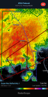
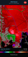
Looked like possible CC spike near Gordonville but I wasn't 100% confident on thatTrained spotter reported a tornado down moving into Cape Girardeau.