
Reports from friend in Memphis: "Bro, the city of Memphis is underwater." Another friend who lives on the rural outskirts has a private driveway with a bridge over a creek that is severely flooding. He was extremely close to getting trapped there and barely even realizes it. They already are back at their house because the water levels have dropped a bit and I'm trying to convince him to leave again asap.
Navigation
Install the app
How to install the app on iOS
Follow along with the video below to see how to install our site as a web app on your home screen.
Note: This feature may not be available in some browsers.
More options
-
Welcome to TalkWeather! We see you lurking around TalkWeather! Take the extra step and join us today to view attachments, see less ads and maybe even join the discussion. CLICK TO JOIN TALKWEATHER
You are using an out of date browser. It may not display this or other websites correctly.
You should upgrade or use an alternative browser.
You should upgrade or use an alternative browser.
Severe WX April 3-6 Severe weather
- Thread starter UncleJuJu98
- Start date
Damage from the Lake City tornado
Horrifying
Horrifying
Schoeppeya
Member
Holly Springs going to be under the gun again here pretty quickly, that supercell is visibly attached to the WF on radar with increasing rotation
TH2002
Member
- Messages
- 4,974
- Reaction score
- 11,116
- Location
- California, United States
- Special Affiliations
- SKYWARN® Volunteer
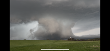
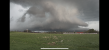
If I posted that photo to Reddit or twitter without context, the weenies would swarm around it like the anchovies from SpongeBob, talking about how a massive EF5 wedge tornado is moving into Nashville right now.Really cool structure on this TN cell. Here's a different traffic cam in TN.
keithGA
Member
@2:45 in that video, a tiny closet is still intact.

CSimonds
Member
Oxford MS storm is starting to look interesting and it is now SVR
That's one of the many reasons why I prefer forums like TalkWeather over places like Reddit or Twitter.If I posted that photo to Reddit or twitter without context, the weenies would swarm around it like the anchovies from SpongeBob, talking about how a massive EF5 wedge tornado is moving into Nashville right now.
As for today's weather, it looks like the cell near Franklin, TN, may be starting to fall apart. Meanwhile, there's a cell near Sardis, MS, that looks concerning--it currently seems to be outflow-dominant, but if it starts to ingest its own outflow boundary, then watch out...
- Thread starter
- #168
Wrong thread guys
Warm front riders can be dangerous. I remember the northwest Alabama EF3 on the morning of 3/2/2012 as the warm front was moving north and reforming up around KY/INHolly Springs going to be under the gun again here pretty quickly, that supercell is visibly attached to the WF on radar with increasing rotation
- Thread starter
- #170
Brad arnold is targeting the storms near Dumas now
Thanksgivingbrown
Member
That Corinth, Ms cell looks concerning
Kds86z
Member
Tornado warned..That Corinth, Ms cell looks concerning
cg9450
Member
and there you have it, TORWThat Corinth, Ms cell looks concerning
Honestly, I’d say the biggest concern is the two partially merged cells in SW Arkansas. If a productive storm merger occurs, it could potentially get interesting.
Edit: Eh, just noticed it’s behind an outflow boundary and moving away from it. Maybe not in that case,
Edit: Eh, just noticed it’s behind an outflow boundary and moving away from it. Maybe not in that case,
Last edited:
MidTNWx
Member
wx_guy
Member
- Messages
- 1,237
- Reaction score
- 4,443
- Location
- United States
- HAM Callsign
- KO4ZGH
- Special Affiliations
- SKYWARN® Volunteer
- ARRL Member
1 hour StormNet AI shows a few cells with potential:

keithGA
Member
Ground scraper wall cloud.Some shots of the TN supercell from an hour ago, taken from the Spring Hill Battlefield. This was about a minute after the storm went tornado warned.