Kds86z
Member
That south of front?Here we go again
Follow along with the video below to see how to install our site as a web app on your home screen.
Note: This feature may not be available in some browsers.
That south of front?Here we go again
Oh for crying out loud. Why does it look so textbook too.Here we go again
It's along the front, I think the this is the warm front right here. Slight reflectivity line. May have a tornado threat eventually with this one, since it's on the warm front.That south of front?

Yes. Looks to be riding just south of the stationary frontThat south of front?
I may not need to chase if this tracks slightly southWonder if any chasers are out on this storm.


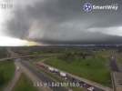
I’m 2 miles south of the 840 junction which you can see is just north of MurfreesboroThings are about to go.
* Just as I say that. A tornado warning south of Nashville View attachment 38925
This is near you @BulkshearJust snagged this off TDOT. i-65 and 840 traffic cam.
Talk about a ground scraper.Just snagged this off TDOT. i-65 and 840 traffic cam.