Model info coming in. This is another 2km resolution run (so it has 125% more grid cells than the 3km HRRR), and it focuses on Arkansas today.
At 2 PM, the tornado threat starts in Arkansas, according to this model's run. It's picking up on UH of 105, which is sufficient for EF1 or EF2 maybe.
View attachment 39005
A locally higher tornado risk manifests at 3PM, according to this model.
View attachment 39006
By 5 PM, it's a madhouse with several high-end supercells with tornadic potential.
View attachment 39010
At 6 PM, mayhem continues! And a considerably Flash Flood threat is manifesting across Arkansas as well. I imagine Flash flood warnings and maybe more tonight.
View attachment 39012
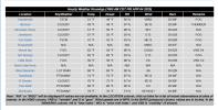
At 7 PM (the furthest the model currently has run), the agony continues, with a very high Tornado and Flash Flood threat. The model is showing some areas, as seen, getting over 5 (additional) inches of rain in 3 hours.
View attachment 39013
For Arkansas, specifically, if this model verifies, the Moderate risk will definitely be warranted, and a High risk should at least be considered (but I still think Moderate is probably the most appropriate due to the small real estate involved). Not sure if Little Rock will avoid the worst, but we'll see!