CheeselandSkies
Member
Of course, OK portion of the setup waits for a few scary HRRR runs (in addition to the WoFS) and a tornado watch to be issued before the Cu dies.
Follow along with the video below to see how to install our site as a web app on your home screen.
Note: This feature may not be available in some browsers.
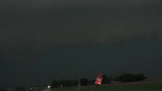
Check out the rotation over Washington, KS.
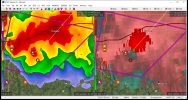
Cause they like messing with us.Right smack dab in the middle of the triangle between UEX, TWX and OAX, with none of them able to scan it below 7,000' or so. Why do the most potent storms/tornadoes in every event lately form either as far as possible from all the closest radar sites, or right on top of one of them?
Check out the rotation over Washington, KS.

OMG!!! It is very eerie in my area.Storms are now firing on the dryline near Wichita.
Brandon Clement has an amazing view of it.Oof. Something big is about to happen, heading right for Chapman (of May 2016 infamy).
The temperature dropped into the 50s in that area.I may have spoken too soon, couplet fell apart on next scan as line crashed into it from the west. May still do something, but not as imminent as I thought a moment ago.