- Thread starter
- #221
Brice Wood
Member
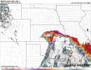
Big hailers possible in Texas today, tornado risk is only a 5%.
Follow along with the video below to see how to install our site as a web app on your home screen.
Note: This feature may not be available in some browsers.
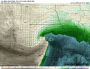
Probably that mixing along the dryline leading to lower moisture quality.Latest HRRR run fails to fire any storms along the dryline into Oklahoma, which is lucky given the parameter space. However, I have a question - the run depicts large CAPE along a pronounced dryline, with no Capping. Therefore why would storms not develop? Is it lack of moisture quality (compared to the open warm sector) right next to the dryline or something else - anyone have any thoughts?.

Broyles'd.View attachment 13720
Been awhile since they said, “an EF3+ tornado may occur.”
.jpg")


.jpg")

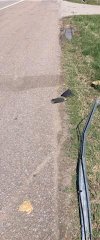
That debarked tree branch will make for an awesome tornadic “souvenir”! He should hang on to that, as it will make for a great memento and decoration with an interesting story behind it.Some of @Shakespeare 2016's damage photos (note he texted these to me so resolution isn't the best, he has more photos so hope to get better copies of those)
View attachment 13721
View attachment 13722
View attachment 13723
View attachment 13724
I hope this tornado gets upgraded to EF4. Go to dat and there was a rather large anchor bolted home with toenails that was almost entirely swept away. Also there is some rather intense context near the house. Yes, I will keep that completely debarked branch as a souvenir.That debarked tree branch will make for an awesome tornadic “souvenir”! He should hang on to that, as it will make for a great memento and decoration with an interesting story behind it.
After the Dayton EF4, I actually found a partially debarked, insulation-caked tree branch in my friend’s yard, one suburb over from where the tornado lifted (debris fallout most likely). I really regret not keeping it now!
It can seems so morbid at times that I am intrigued by looking at tornado damage. I saw the damage and I was just like wow.That debarked tree branch will make for an awesome tornadic “souvenir”! He should hang on to that, as it will make for a great memento and decoration with an interesting story behind it.
After the Dayton EF4, I actually found a partially debarked, insulation-caked tree branch in my friend’s yard, one suburb over from where the tornado lifted (debris fallout most likely). I really regret not keeping it now!
Is it on the DAT for sure, and if so where at? All the swept away homes I have seen so far appear to have separated from their subfloors, which is EF3. Did they maybe remove the damage point from the DAT? Not doubting you though, especially if you saw it in person. If one of the homes did indeed have its subfloor ripped off, I'd have to agree with you.I hope this tornado gets upgraded to EF4. Go to dat and there was a rather large anchor bolted home with toenails that was almost entirely swept away. Also there is some rather intense context near the house. Yes, I will keep that completely debarked branch as a souvenir.


.jpg")
.jpg")
.jpg")