• Welcome to TalkWeather!
    We see you lurking around TalkWeather! Take the extra step and join us today to view attachments, see less ads and maybe even join the discussion.
    CLICK TO JOIN TALKWEATHER

Severe WX April 28th-29th, 2020 Severe Weather Threat

Taylor Campbell

Moderator
Moderator
PerryW Project Supporter
Messages
2,102
Reaction score
2,189
Location
Wedowee, AL
Special Affiliations
  1. SKYWARN® Volunteer
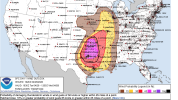
A thread for the severe weather threat tomorrow April 28th and Wednesday April 29th, 2020.
 
Last edited:

Bevo

Member
Messages
241
Reaction score
201
Location
Dallas, TX
The volatile environment ahead of the squall line makes me nervous...none of the models are showing development occurring directly ahead of the line (save for the most northeastern parts in AK/OK) but the environment in and around the Dallas-Fort Worth metroplex seems very conducive to tornadoes should something pop up. I'm talking 600+ SRH and 3500+ CAPE around 04z. Looking at the 2% tor SPC risk at the current moment makes me feel a bit better since they don't seem to have higher confidence in development, but still...
 

Brice

Member
Messages
353
Reaction score
227
Location
Lynchburg, Virginia
The volatile environment ahead of the squall line makes me nervous...none of the models are showing development occurring directly ahead of the line (save for the most northeastern parts in AK/OK) but the environment in and around the Dallas-Fort Worth metroplex seems very conducive to tornadoes should something pop up. I'm talking 600+ SRH and 3500+ CAPE around 04z. Looking at the 2% tor SPC risk at the current moment makes me feel a bit better since they don't seem to have higher confidence in development, but still...


The biggest chance for tornadoes will be, of course, the supercells that form in Texas/Oklahoma and the Midwest with a line of possibly discrete cells. I agree enhanced risk is enough since it will be a couple of squall lines rolling through.
 

Bama Ravens

Member
Messages
1,207
Reaction score
648
Location
Morris, AL (Northern Jefferson County)
BMX forecast discussion. They sound unimpressed with the threat for their area.

Wednesday through Monday.

Due to a stronger than expected cold pool from early morning
storms to our west, the severe weather threat for Wednesday
afternoon now appears that it may not materialize in the same
fashion as previously expected. A weakened band of convection
should enter west Alabama around 6 AM with MUCAPE of 500-1000 J/kg
possible in a small corridor ahead of the line. Isolated strong
to marginally severe wind gusts cannot be ruled out as this band
moves across the forecast area through the morning. There is
little evidence pointing toward restrengthening of the line, but
daytime heating could help maintain a chance of marginally severe
gusts across our eastern counties during the afternoon. For
consistency and to avoid wholesale changes, a Marginal Risk will
be kept in our forecast but only for isolated damaging winds.
Additional showers or perhaps a few thunderstorms could develop in
the afternoon and evening as strong PVA and mid-level cold
advection occurs from the northwest. This potential is unclear,
but gusty winds might be possible with any such convection.
 

Kory

Member
Messages
4,928
Reaction score
2,119
Location
Tuscaloosa, Alabama
Yeah this looks like a nasty damaging wind threat to our NW. The QLCS will begin to lose focus as it shifts SE away from better instability and forcing (I.e toward MS/AL/TN).
 

Bevo

Member
Messages
241
Reaction score
201
Location
Dallas, TX
DFW Metro upgraded to moderate for straight line wind damage 75+mph. Might be looking at a derecho event? What an absolute monster of a system, reaching all the way from Illinois down to south Texas.
Would be a good idea to charge up electronics now before this rolls in, because there could be a good bet that some power grids are gonna be throttled.
 

Attachments

  • Screen Shot 2020-04-28 at 12.39.02.png
    Screen Shot 2020-04-28 at 12.39.02.png
    1.1 MB · Views: 0

MattW

Member
Messages
307
Reaction score
206
Location
Decatur, GA
HAM Callsign
KG4GUF
Special Affiliations
  1. SKYWARN® Volunteer
For Atlanta, the HRRR and NAM 3km paint almost opposite pictures, though I notice the NAM does seem to be trending somewhat downward in terms of threat.
 

KoD

Moderator
Staff member
Moderator
PerryW Project Supporter
Messages
1,380
Reaction score
697
Location
Huntsville, AL
And we're off

EnormousSadDog-size_restricted.gif
 

Bevo

Member
Messages
241
Reaction score
201
Location
Dallas, TX
Oh man there’s probably some nasty straight line winds with this sucker. ETA Denton probably 30ish mins.
 

Attachments

  • 7617EE6A-C245-46DE-899B-5DE1A4D4429A.png
    7617EE6A-C245-46DE-899B-5DE1A4D4429A.png
    726.3 KB · Views: 0

bwalk

Member
Messages
597
Reaction score
291
Location
Prattville, Al
At 11:30 pm a solid wall of connecting Severe Thunderstorm Warnings from sw of Ft. Worth all the way to the Missouri state line. Been awhile since we’ve seen that long of a continuous line of warnings.
 

Tyler Penland

Mountain Snow Miser
Staff member
Moderator
Messages
254
Reaction score
154
Location
Blowing Rock, NC; Elevation 3,575ft
Interested to see what happens in GA/sc/nc later on. Every model had an initial round of convection coming through this morning from the leftovers of that Midwest line that decided to visit the LA gulf coast instead. HRRR has pockets of decent instability developing. Still won't be widespread severe by any means but could keep things more interesting.

Sent from my SM-G960U using Tapatalk
 

MattW

Member
Messages
307
Reaction score
206
Location
Decatur, GA
HAM Callsign
KG4GUF
Special Affiliations
  1. SKYWARN® Volunteer
And now the slight risk is entirely gone.
 
Logo 468x120
Back
Top