
Navigation
Install the app
How to install the app on iOS
Follow along with the video below to see how to install our site as a web app on your home screen.
Note: This feature may not be available in some browsers.
More options
-
Welcome to TalkWeather! We see you lurking around TalkWeather! Take the extra step and join us today to view attachments, see less ads and maybe even join the discussion. CLICK TO JOIN TALKWEATHER
You are using an out of date browser. It may not display this or other websites correctly.
You should upgrade or use an alternative browser.
You should upgrade or use an alternative browser.
Severe WX April 25-27, 2023 (Southern States)
- Thread starter KevinH
- Start date
TH2002
Member
- Messages
- 4,974
- Reaction score
- 11,116
- Location
- California, United States
- Special Affiliations
- SKYWARN® Volunteer
Have a couple tornado warnings in Florida and Georgia at the moment
TH2002
Member
- Messages
- 4,974
- Reaction score
- 11,116
- Location
- California, United States
- Special Affiliations
- SKYWARN® Volunteer
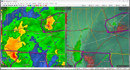
Probable tornado approaching the FL/GA border


TH2002
Member
- Messages
- 4,974
- Reaction score
- 11,116
- Location
- California, United States
- Special Affiliations
- SKYWARN® Volunteer
 Big debris sig now moving out of the warning polygon
Weatherphreak
Member
My buddy is sending me some pretty crazy looking pictures near Cocoa Beach and Titusville of those tornado warning storms
- Moderator
- #147
Why isn't Lowndes County, MS under a tornado warning?
Weatherphreak
Member
Near Cocoa Beach earlier
CheeselandSkies
Member
These storms over the Florida Panhandle today have had the radar look of tropical mini-supercells, and been relatively efficient tornado producers. Yet that isolated beast over Texas yesterday seemed to have trouble planting one for more than a minute or so. Interesting stuff.
Attachments
CheeselandSkies
Member
Tomorrow looks like a carbon copy of yesterday for DFW and/or points just south along the I-35 corridor; giant hail once again likely along with a conditional tornado threat.
TH2002
Member
- Messages
- 4,974
- Reaction score
- 11,116
- Location
- California, United States
- Special Affiliations
- SKYWARN® Volunteer
Impressive isolated supercell out by the West Palm Beach radar
.THERE IS AN ENHANCED RISK OF SEVERE THUNDERSTORMS CENTRAL
TEXAS...
...SUMMARY...
Scattered storms are forecast to produce damaging hail and severe
winds from late afternoon through evening from north-central Texas
to the middle and lower Rio Grande Valley. Isolated strong to severe
storms may also occur over parts of the Southeast into the central
Appalachians.
...Synopsis...
Latest water-vapor imagery and analyses depict a mid-level shortwave
trough undergoing slight deepening over the central Rockies. This is
within a strong cold advection regime, behind a southward-surging
cold front over the Rockies and central High Plains. Both of these
features are expected to continue southward over the next 24 hours,
with the upper trough likely reaching northern Mexico and the
attendant cold front sweeping into central TX by around 21 UTC this
afternoon. Additionally, a second, less intense, upper perturbation
is noted over the mid-MS Valley migrating to the east/northeast. A
weak surface low associated with this feature is forecast to lift
into parts of the upper OH Valley, with modest lee cyclogenesis east
of the Appalachians. Thunderstorm development under the upper low
and in the vicinity of the lee low appears probable around peak
heating.
...Central to southern Texas...
00 UTC soundings from across the High Plains/Rockies sampled steep
mid-level lapse rates in excess of 8 C/km. This corroborates recent
RAP analysis that show the lapse rate plume extending over NM into
west TX. Northwesterly 700-500 mb mean flow will advect these lapse
rates into central TX over the next 12-18 hours. At the surface,
modest moisture advection is occurring over central TX to the
coastal plain, amid weak surface pressure falls over west TX. Mid
50s to low 60s dewpoints should migrate into central TX by early
afternoon. This moisture return will become more pronounced through
the morning hours as the surface low deepens, and shifts eastward in
tandem with the approaching upper wave. This combination of
increasing low-level moisture and steepening mid-level lapse rates
should establish a corridor of 3000-3500 J/kg MLCAPE from southern
to central TX by early to mid afternoon. The positive tilt of the
upper trough over southern NM will spread 50-60 knot zonal mid-level
winds over the warm sector, with effective bulk shear values
approaching 50 knots.
Diurnal warming, combined with broad ascent in the vicinity of the
surface low over central TX, may allow for convective initiation as
early as 18-20 UTC, near a diffuse triple point and/or along a
sharpening dryline roughly parallel with the I-35 corridor. Initial
storm modes will likely be discrete supercells, given favorable flow
orientation away from the zone of initiation and elongated
hodographs. These early cells will pose a risk for large to very
large (2+ inch) hail as well as a tornado threat - especially in the
vicinity of the surface warm front where low-level helicity will be
maximized. However, the window/longevity for discrete supercells is
uncertain. Recent surface observations across the High Plains show a
faster frontal progression than depicted by most guidance. As such,
the arrival of the cold front into central TX may foster rapid
upscale growth into a squall line faster than expected by 00z CAMs.
The primary hazard is expected to quickly transition to severe wind
once the MCS becomes established and propagates southeastward
towards the TX Coastal Plain. A strong line-orthogonal deep-layer
shear component suggest this MCS may be fairly progressive and
capable of a few 75+ mph wind gusts. However, the eastward and
westward extent of the wind threat is uncertain, given a tight
buoyancy gradient across east TX and the potential for frontal
undercutting across south-central TX.
...Upper OH River Valley to the Mid-Atlantic...
Daytime heating under the upper-low should bolster MLCAPE values to
500-1000 J/kg across the upper OH Valley region and into the
Mid-Atlantic by peak heating this afternoon. While mid-level lapse
rates will be meager, deep-layer shear values on the order of 25-30
knots should support some storm organization with an attendant
hail/damaging wind threat. Damaging gusts may be more common across
parts of the Mid-Atlantic where daytime highs in the mid 70s will
support steep lapse rates in the 0-1 km layer that may allow for
more efficient downdraft acceleration.
...Florida...
A convective cluster ongoing over the central Gulf of Mexico is
forecast to migrate eastward, reaching the FL Peninsula by around 12
UTC. Diurnal warming ahead of this cluster of storms should support
increasing buoyancy with MLCAPE values reaching near 1500 J/kg by
mid-afternoon. 30-40 knot mid-level flow on the southern periphery
of the eastern wave will allow for some elongation of the deep-layer
hodograph conducive for some organization of semi-discrete
cells/clusters. The threat for severe hail/damaging winds will
likely be greatest across the eastern FL coast, where diurnal
warming will be maximized ahead of any convection.

Austin Dawg
Member
Looks like a fun day tomorrow.
Codell, Kansas was hit by a tornado on May 20th, 1916... the following year, on May 20th, 1917, another.... Then, the following year, on May 20, 1918, another. Those things do happen.You get that voodoo away from me! Not that date! Alabama should be exempt permanently from tornadoes on that date. Just saying.
Austin Dawg
Member
Hail... I hope not, and I don't want to replace the roof and take the car to the body shop again. The timing is like the last time we got significant hail. My wife is still at work, with her car is parked outside when the storms come through. At least I bought a better roof that should help unless it sells baseball size stones. Then you try to find a place to hide until it's over.
TH2002
Member
- Messages
- 4,974
- Reaction score
- 11,116
- Location
- California, United States
- Special Affiliations
- SKYWARN® Volunteer
FWIW, the GFS is showing that at least a marginal tornado threat could develop further south in Tamaulipas, Mexico today
TH2002
Member
- Messages
- 4,974
- Reaction score
- 11,116
- Location
- California, United States
- Special Affiliations
- SKYWARN® Volunteer
SPC went with a 50/20 tornado watch south of the DFW metro
Storm Prediction Center Tornado Watch 177
Severe weather, tornado, thunderstorm, fire weather, storm report, tornado watch, severe thunderstorm watch, mesoscale discussion, convective outlook products from the Storm Prediction Center.
www.spc.noaa.gov