
Navigation
Install the app
How to install the app on iOS
Follow along with the video below to see how to install our site as a web app on your home screen.
Note: This feature may not be available in some browsers.
More options
-
Welcome to TalkWeather! We see you lurking around TalkWeather! Take the extra step and join us today to view attachments, see less ads and maybe even join the discussion. CLICK TO JOIN TALKWEATHER
You are using an out of date browser. It may not display this or other websites correctly.
You should upgrade or use an alternative browser.
You should upgrade or use an alternative browser.
Severe WX April 25-27, 2023 (Southern States)
- Thread starter KevinH
- Start date
- Thread starter
- #23
KevinH
Member
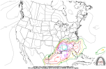
80% contour right next to me? The GFS can kiss it. lol18z CWASP GFS and NAM. I suspect SPC will be upping their wording during the next couple days and adding a Marginal to Slight Risk at Day 3 at the very least.

Ugh
- Thread starter
- #25
KevinH
Member
I will include them here. SPC still seems bullish about Thursday.Do we want to include 4/25 and 4/26 here or keep them in the severe weather 2023 thread?
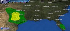
Day 3 Convective Outlook
NWS Storm Prediction Center Norman OK
0229 AM CDT Tue Apr 25 2023
Valid 271200Z - 281200Z
...THERE IS A MARGINAL RISK OF SEVERE THUNDERSTORMS OVER MUCH OF
LOUISIANA...MISSISSIPPI...AND ALABAMA...
...SUMMARY...
At least isolated severe storms will be possible across parts of the
central Gulf Coast states on Thursday, with damaging gusts and hail.
...Synopsis...
On Thursday, a low-amplitude trough will move east across the lower
MS Valley toward the OH/TN Valleys, becoming less defined by
afternoon. Still, 500 mb wind speeds of 40+ kt will be common from
eastern TX into KY/TN.
At the surface, weak low pressure will exist over LA and MS, with a
cold front decelerating into LA and northwest MS through 00Z. While
surface winds will be light east of the cold front, mid to upper 60s
dewpoints will return into the LA/MA/AL area, resulting in
destabilization.
Elsewhere, a potent upper trough will develop over the northern
Rockies and High Plains, with strong cooling aloft pushing south
toward the central Rockies/High Plains by Friday morning. Lift along
a southward-surging cold front may yield a few thunderstorms in a
weakly unstable air mass with steep lapse rates, with locally strong
gusts in part due to the convection.
...Central Gulf Coast States...
Morning convection is expected to stretch from OK into TN within a
weak theta-e advection regime and north of a warm front. This
boundary will lift north into northern MS and AL by late afternoon,
with areas of storms possible during the day.
The greatest opportunity for severe storms will be during the
afternoon, as pockets of heating aid destabilization well ahead of
the cold front. Possible foci for development will be the cold front
over LA/northwest MS and any outflows from earlier convection, but
storms may also form during the peak-heating hours due to the
increasing moisture and uncapped air mass.
That said, significant model differences exist with when and where
antecedent convection will occur, and this currently precludes a
Slight Risk. For example, the ECMWF shows widespread storms over the
northern Gulf of Mexico, which would hamper destabilization inland.
In addition, 850 mb winds will only average 15-25 kt, which will
reduce SRH. As such, will introduce low probabilities at this time
for wind and hail potential.
Please continue to comment with your CWASPS (my faves lol) and model runs for this event, and I will adjust the title as needed.
Last edited:
- Thread starter
- #26
KevinH
Member
Thread title changed to include Texas.
Please note: I normally only include states in the title that are in slight risk or higher. I created this thread when the CWASP had 80% contours over AL/GA. Since the SPC isn’t sure yet, I added the question marks for AL/GA.
Please note: I normally only include states in the title that are in slight risk or higher. I created this thread when the CWASP had 80% contours over AL/GA. Since the SPC isn’t sure yet, I added the question marks for AL/GA.
- Thread starter
- #27
KevinH
Member
Tomorrow’s ENH risk is hail driven.Do we want to include 4/25 and 4/26 here or keep them in the severe weather 2023 thread?

TOR risk tomorrow per the SPC:

- Moderator
- #28
Oh bother. We're leaving for TN for a few days this morning and will be driving home Thursday! UGH!! Should we stay up there an extra day? (It's Gatlinburg, pretty much safe from tornadoes there.)
Anyone have the latest CWASP maps? I forgot to look at it before I left the house this morning
- Thread starter
- #30
KevinH
Member
I don’t know how to pull it up :/Anyone have the latest CWASP maps? I forgot to look at it before I left the house this morning
EDIT: Found it lol
Last edited:
- Thread starter
- #31
KevinH
Member
What does the “TUE 140429” mean at the bottom? Can’t be for the year is it?
Also l, where do you find these? Lol
ashtonlemleywx
Member

Impressive sounding for South MS Thursday night from the 12z NAM
ashtonlemleywx
Member
.gif")
Check out these supercells firing off in Mississippi Thursday evening on the 12z NAM 3km
Lovely and I say that sarcastically View attachment 20123
Check out these supercells firing off in Mississippi Thursday evening on the 12z NAM 3km
- Thread starter
- #35
KevinH
Member
Uhm... excuse me?? I know this doesn't say 12 does it?
Texas.....
10P CDT/11PM tonight....... No....

1am CT/2am tomorrow... No...

4amCT/5pmET..... No..

Main Page: https://www.eas.slu.edu/CIPS/MODEL/WXmodel.php
Page where this graphics came from: https://www.eas.slu.edu/CIPS/MODEL/WXmodel.php?&model=nam212&run=2023042512&map=CWASP&fhr=00
Texas.....
10P CDT/11PM tonight....... No....
1am CT/2am tomorrow... No...
4amCT/5pmET..... No..
Main Page: https://www.eas.slu.edu/CIPS/MODEL/WXmodel.php
Page where this graphics came from: https://www.eas.slu.edu/CIPS/MODEL/WXmodel.php?&model=nam212&run=2023042512&map=CWASP&fhr=00
Last edited:
- Thread starter
- #36
KevinH
Member
LA/MS/AL
10 p.m.CT/11 p.m.ET..... NO!!!!

1 a.mCT/2 a.m.ET..... NO!!!!!!

Main Page: https://www.eas.slu.edu/CIPS/MODEL/WXmodel.php
Page where this graphics came from: https://www.eas.slu.edu/CIPS/MODEL/WXmodel.php?&model=nam212&run=2023042512&map=CWASP&fhr=00
10 p.m.CT/11 p.m.ET..... NO!!!!
1 a.mCT/2 a.m.ET..... NO!!!!!!
Main Page: https://www.eas.slu.edu/CIPS/MODEL/WXmodel.php
Page where this graphics came from: https://www.eas.slu.edu/CIPS/MODEL/WXmodel.php?&model=nam212&run=2023042512&map=CWASP&fhr=00
- Thread starter
- #37
KevinH
Member
I am glad the STP is only ONE thing that is considered. Even with STP #s that seem high (to me), the SPC still maintains the 5% TOR risk.

- Thread starter
- #38
KevinH
Member
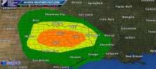
DAY 1 CONVECTIVE OUTLOOK
NWS STORM PREDICTION CENTER NORMAN OK
1124 AM CDT TUE APR 25 2023
VALID 251630Z - 261200Z
...THERE IS A SLIGHT RISK OF SEVERE THUNDERSTORMS ACROSS PARTS OF
TEXAS AND SOUTHWESTERN OKLAHOMA...
..SUMMARY
SEVERE THUNDERSTORMS ARE POSSIBLE MAINLY LATE THIS AFTERNOON INTO
TONIGHT OVER PARTS OF THE SOUTHERN PLAINS, WITH A RISK FOR LARGE TO
VERY LARGE HAIL, DAMAGING WINDS, AND PERHAPS A COUPLE OF TORNADOES.
..SOUTHERN PLAINS
AN UPPER TROUGH/LOW CENTERED OVER THE GREAT BASIN AND CENTRAL
ROCKIES THIS MORNING WILL ADVANCE SOUTH-SOUTHEASTWARD TOWARDS THE
FOUR CORNERS BY THIS EVENING, AND WILL EVENTUALLY REACH THE SOUTHERN
HIGH PLAINS LATE TONIGHT. A SUBTLE, SOUTHERN-STREAM PERTURBATION
OVER NORTHERN MEXICO WILL MOVE EASTWARD ACROSS WEST/CENTRAL TX
THROUGH THE DAY. AT THE SURFACE, WEAK CYCLOGENESIS SHOULD OCCUR
ACROSS EASTERN NM THIS AFTERNOON/EVENING. LOW-LEVEL MOISTURE,
CHARACTERIZED BY GENERALLY LOW 50S TO LOW 60S SURFACE DEWPOINTS,
WILL CONTINUE STREAMING NORTHWARD TODAY ALONG/SOUTH OF A WARM FRONT
AND EAST OF A DRYLINE.
CONVECTIVE POTENTIAL AND EVOLUTION ACROSS THE WARM SECTOR THIS
AFTERNOON THROUGH TONIGHT REMAINS UNCLEAR OWING TO WEAK/NEBULOUS
LARGE-SCALE ASCENT. STILL, THE BEST SIGNAL FOR THUNDERSTORM
INITIATION APPEARS TO BE ACROSS THE HIGHER TERRAIN OF SOUTHEASTERN
CO AND NORTHEASTERN NM THIS AFTERNOON WITH WEAK LOW-LEVEL UPSLOPE
FLOW OCCURRING AND ASCENT FROM THE APPROACHING UPPER TROUGH. THIS
ACTIVITY SHOULD SPREAD GENERALLY SOUTHEASTWARD ACROSS THE OK/TX
PANHANDLES AND EVENTUALLY NORTHWEST TX. ALTHOUGH LOW-LEVEL MOISTURE
WILL REMAIN RATHER LIMITED, THE PRESENCE OF STEEP MID-LEVEL LAPSE
RATES AND 30-40 KT OF DEEP-LAYER SHEAR SHOULD PROVE SUFFICIENT FOR
THUNDERSTORM ORGANIZATION, INCLUDING THE POTENTIAL FOR MULTIPLE
SUPERCELLS POSING A THREAT FOR MAINLY LARGE HAIL.
CONFIDENCE IN GREATER COVERAGE OF INTENSE CONVECTION HAS INCREASED
ENOUGH TO EXPAND THE SLIGHT RISK FARTHER NORTHWEST INTO PARTS OF THE
TX PANHANDLE. THESE THUNDERSTORMS SHOULD CONTINUE EAST-SOUTHEASTWARD
TOWARDS NORTHWEST TX AND SOUTHWESTERN OK THIS EVENING/TONIGHT. THE
ACTIVITY IN OK WILL PROBABLY TEND TO BECOME ELEVATED TO THE NORTH OF
THE WARM FRONT, BUT IT MAY STILL POSE SOME THREAT FOR HAIL. GUSTY
WINDS WILL BE POSSIBLE WITH ANY CLUSTERS THAT CAN PERSIST WITH
EASTWARD EXTENT TONIGHT FROM NORTHWEST INTO CENTRAL TX.
THE PROSPECT FOR CONVECTIVE INITIATION ALONG THE DRYLINE THIS
AFTERNOON FROM NORTHWEST TO CENTRAL TX STILL APPEARS RATHER
CONDITIONAL, AS A PRONOUNCED CAP NOTED ON 12Z SOUNDINGS FROM MAF AND
DRT WILL BE SLOW TO ERODE AND POTENTIALLY DIFFICULT TO BREACH.
WIDESPREAD LOW-LEVEL CLOUD COVER NOTED ON MORNING VISIBLE SATELLITE
IMAGERY EAST OF THE DRYLINE WILL NEED TO MIX OUT TO SOME EXTENT TO
GENERATE SUFFICIENT DIURNAL HEATING TO SUPPORT PARCELS BEING LIFTED
NEAR/TO THEIR LFCS. A SOMEWHAT BETTER CHANCE FOR SURFACE-BASED
CONVECTIVE DEVELOPMENT MAY BE ACROSS NORTHWEST INTO WESTERN NORTH
TX, WHERE SOME CLOUD BREAKS AND FILTERED DAYTIME HEATING HAVE
ALREADY BEEN OBSERVED. IF THUNDERSTORMS CAN FORM AND BE SUSTAINED
ACROSS THIS REGION, THEY WILL LIKELY BE SUPERCELLS AND POSE A THREAT
FOR LARGE TO VERY LARGE HAIL INITIALLY GIVEN THE PRESENCE OF
MODERATE INSTABILITY, STEEP MID-LEVEL LAPSE RATES, AND SUFFICIENT
EFFECTIVE BULK SHEAR. AS A SOUTHERLY LOW-LEVEL JET MODESTLY
STRENGTHENS THIS EVENING, THERE MAY ALSO BE A NARROW, 2-4 HOUR
WINDOW (FROM ROUGHLY 22-02Z) FOR A COUPLE OF TORNADOES WITH ANY
SUPERCELL THAT CAN REMAIN SURFACE BASED.
THE POSSIBILITY OF OPEN WARM SECTOR DEVELOPMENT THIS AFTERNOON ALSO
REMAINS APPARENT OVER PORTIONS OF COASTAL/SOUTHEAST TX. IF THIS
ACTIVITY FORMS, IT WOULD LIKELY BE TIED TO WEAK LOW-LEVEL WARM
ADVECTION AND DAYTIME HEATING ON THE SOUTHERN FRINGE OF PERSISTENT
CLOUD COVER. ANY THUNDERSTORMS THAT CAN PERSIST IN THIS REGIME MAY
POSE A THREAT FOR LARGE HAIL AND DAMAGING WINDS. BASED ON SIGNALS IN
12Z GUIDANCE ON WHERE THIS CONVECTION MAY DEVELOP, HAVE EXPANDED THE
SLIGHT RISK A LITTLE SOUTHEASTWARD TOWARDS THE MIDDLE TX COAST.
..FLORIDA
GENERALLY ZONAL FLOW ALOFT WILL PERSIST OVER THE FL PENINSULA TODAY.
WITH ROBUST DIURNAL HEATING EXPECTED, SCATTERED THUNDERSTORMS SHOULD
ONCE AGAIN DEVELOP ALONG BOTH THE ATLANTIC AND GULF COAST SEA
BREEZES THIS AFTERNOON, AND TO THE SOUTH OF A REMNANT FRONT DRAPED
ACROSS THE NORTH/CENTRAL FL PENINSULA. WHILE LOW-LEVEL WINDS WILL
REMAIN WEAK, STRENGTHENING WEST-SOUTHWESTERLY FLOW AT MID/UPPER
LEVELS SHOULD SUPPORT AROUND 30-35 KT OF DEEP-LAYER SHEAR. THIS
SHOULD BE SUFFICIENT FOR SOME UPDRAFT ORGANIZATION, INCLUDING THE
POTENTIAL FOR A MIX OF MULTICELLS AND PERHAPS MARGINAL SUPERCELL
STRUCTURES. WITH SEASONABLY COOL MID-LEVEL TEMPERATURES PRESENT,
SOME OF THESE THUNDERSTORMS COULD POSE AN ISOLATED THREAT FOR SEVERE
HAIL AND DAMAGING WIND GUSTS THIS AFTERNOON AND EARLY EVENING.
- Thread starter
- #39
KevinH
Member
HELPFUL LINKS TO BOOKMARK (especially since we are in THAT time of year):
https://kamala.cod.edu/spc/ -For those of you that are new to this forum or who do not already know, the SPC website can take a few minutes to "update" when they issue MD, watches, or Outlooks, etc., but this website gives you a sneak peek as to what you will see when the SPC updates their website.
IEMbot - Some people use this website to "spy" on the SPC or NWS chat. You can choose what NWS office (or SPC) to want to follow. The site refreshes automatically every 7 seconds. When I have had this site open, it has alerted me to watches and warnings in my area BEFORE my weather radio does NUMEROUS times. This bot has several "accounts" on Twitter for each NWO and the SPC. The IEMBot for your NWS office could be a good one to follow and enable account notifications for. You just need to know the call letters of your NWS office.)
CIPS Experimental Analog-Based Severe Probability Guidance - I don't know enough about meteorology to explain this website in further detail, so if anyone else would like to chime in, please do.
CIPS Historical Analog Guidance - Same as above. Chime in if you can lol
CIPS Deterministic Model Guidance - I believe a good number of graphics on this forum come from this site. Again, chime in if you can")
Z Time Conversion Table (#1) - SPC Products (and other graphics) are issued using 24 hour Z time. This website helps those in the US determine what time Z time is for their time zone (Alaska, Pacific, Mountain, Central, Eastern) via a chart. It really is just simply math once you figure it out.
Z Time Conversion Table (#2) - Same info, but gives a history of Z time and also includes Guam, Hawaii, and Atlantic time zones.
NWSTornado @ Twitter - Tweets out tornado warnings issued by the NWS across the US in real time with graphics. Tweets from this account have been used on this forum. Another good account to enable notifications for when you are under a WW.
Feel free to add any other links you think people should bookmark.
Annnnnnd my lunch break is over.. back to work lol
https://kamala.cod.edu/spc/ -For those of you that are new to this forum or who do not already know, the SPC website can take a few minutes to "update" when they issue MD, watches, or Outlooks, etc., but this website gives you a sneak peek as to what you will see when the SPC updates their website.
IEMbot - Some people use this website to "spy" on the SPC or NWS chat. You can choose what NWS office (or SPC) to want to follow. The site refreshes automatically every 7 seconds. When I have had this site open, it has alerted me to watches and warnings in my area BEFORE my weather radio does NUMEROUS times. This bot has several "accounts" on Twitter for each NWO and the SPC. The IEMBot for your NWS office could be a good one to follow and enable account notifications for. You just need to know the call letters of your NWS office.)
CIPS Experimental Analog-Based Severe Probability Guidance - I don't know enough about meteorology to explain this website in further detail, so if anyone else would like to chime in, please do.
CIPS Historical Analog Guidance - Same as above. Chime in if you can lol
CIPS Deterministic Model Guidance - I believe a good number of graphics on this forum come from this site. Again, chime in if you can
Z Time Conversion Table (#1) - SPC Products (and other graphics) are issued using 24 hour Z time. This website helps those in the US determine what time Z time is for their time zone (Alaska, Pacific, Mountain, Central, Eastern) via a chart. It really is just simply math once you figure it out.
Z Time Conversion Table (#2) - Same info, but gives a history of Z time and also includes Guam, Hawaii, and Atlantic time zones.
NWSTornado @ Twitter - Tweets out tornado warnings issued by the NWS across the US in real time with graphics. Tweets from this account have been used on this forum. Another good account to enable notifications for when you are under a WW.
Feel free to add any other links you think people should bookmark.
Annnnnnd my lunch break is over.. back to work lol
- Thread starter
- #40
KevinH
Member
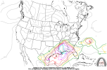
CWASP for 00z (8pmET) Thursday eveningAnyone have the latest CWASP maps? I forgot to look at it before I left the house this morning
GFS
View attachment 20137
and NAM

Source: CIPS Deterministic Model Guidance