
- Moderator
- #1
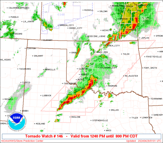
Another severe weather event with significant parameters.
Follow along with the video below to see how to install our site as a web app on your home screen.
Note: This feature may not be available in some browsers.


These cells are not sustaining themselves at all...
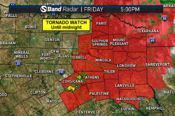
Tornado Warning
TXC147-277-250045-
/O.NEW.KFWD.TO.W.0029.200424T2355Z-200425T0045Z/
BULLETIN - EAS ACTIVATION REQUESTED
Tornado Warning
National Weather Service Fort Worth TX
655 PM CDT Fri Apr 24 2020
The National Weather Service in Fort Worth has issued a
* Tornado Warning for...
Northwestern Lamar County in north central Texas...
Northeastern Fannin County in north central Texas...
* Until 745 PM CDT.
* At 655 PM CDT, a confirmed tornado was located 10 miles northwest
of Honey Grove, or 14 miles northeast of Bonham, moving east at 35
mph.
HAZARD...Damaging tornado and ping pong ball size hail.
SOURCE...Emergency Management confirmed tornado.
IMPACT...Flying debris will be dangerous to those caught without
shelter. Mobile homes will be damaged or destroyed.
Damage to roofs, windows, and vehicles will occur. Tree
damage is likely.
* The tornado will be near...
Paris around 745 PM CDT.
Other locations impacted by this tornadic thunderstorm include Toco.
PRECAUTIONARY/PREPAREDNESS ACTIONS...
To repeat, a tornado is on the ground. TAKE COVER NOW! Move to an
interior room on the lowest floor of a sturdy building. Avoid
windows. If you are outdoors, in a mobile home, or in a vehicle, move
to the closest substantial shelter and protect yourself from flying
debris.
&&
LAT...LON 3386 9556 3358 9560 3363 9609 3381 9607
3386 9603 3384 9602 3385 9600 3387 9600
3386 9598 3385 9598 3386 9595 3389 9594
3384 9584 3384 9582 3386 9581 3384 9577
3385 9576 3388 9576
TIME...MOT...LOC 2355Z 274DEG 28KT 3372 9599
TORNADO...OBSERVED
HAIL...1.50IN
$$
Godwin

Yeah this one over Rabun is crazy good structure for the terrain it's been going over.Those are pretty storms.
