CheeselandSkies
Member
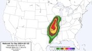
18Z HRRR and 3K NAM continue to suggest that much of MO into northern AR have a problem tomorrow. Instability axis ahead of the cold front gradually getting wider compared to earlier runs.
Follow along with the video below to see how to install our site as a web app on your home screen.
Note: This feature may not be available in some browsers.
I agree. The high-end EF3 Nappanee tornado of 2007 was produced in a line of severe storms.I think that's nonsense, low level shear is strong enough for significant tornadoes with either supercellular or QLCS modes.


Observed surface based cape is definitely outperforming where the breaks in the clouds are, few more degrees of warming and it shouldn’t be an issueDecent amount of clearing in AR/southern MO on visible satellite.
While some lingering cloud cover and showers remain, seems that convection from overnight largely dissipated. The exception being mainly over west-central MO where the bulk of the remnants are moving into now.
Currently 60 in Central MO and expected to climb to 72 in the next few hours so it'll be interesting to see what happensObserved surface based cape is definitely outperforming where the breaks in the clouds are, few more degrees of warming and it shouldn’t be an issue

 youtube.com