
KevinH
Member
It probably was until you said that. Loli think dixie may be done with severe weather until the fall.
Follow along with the video below to see how to install our site as a web app on your home screen.
Note: This feature may not be available in some browsers.
It probably was until you said that. Loli think dixie may be done with severe weather until the fall.

O lovely..... right over my house again.....


What's your source for this? I didn't think we were in range of any of the CAMs yet.
GFDL C-SHiELD (Experimental)What's your source for this? I didn't think we were in range of any of the CAMs yet.


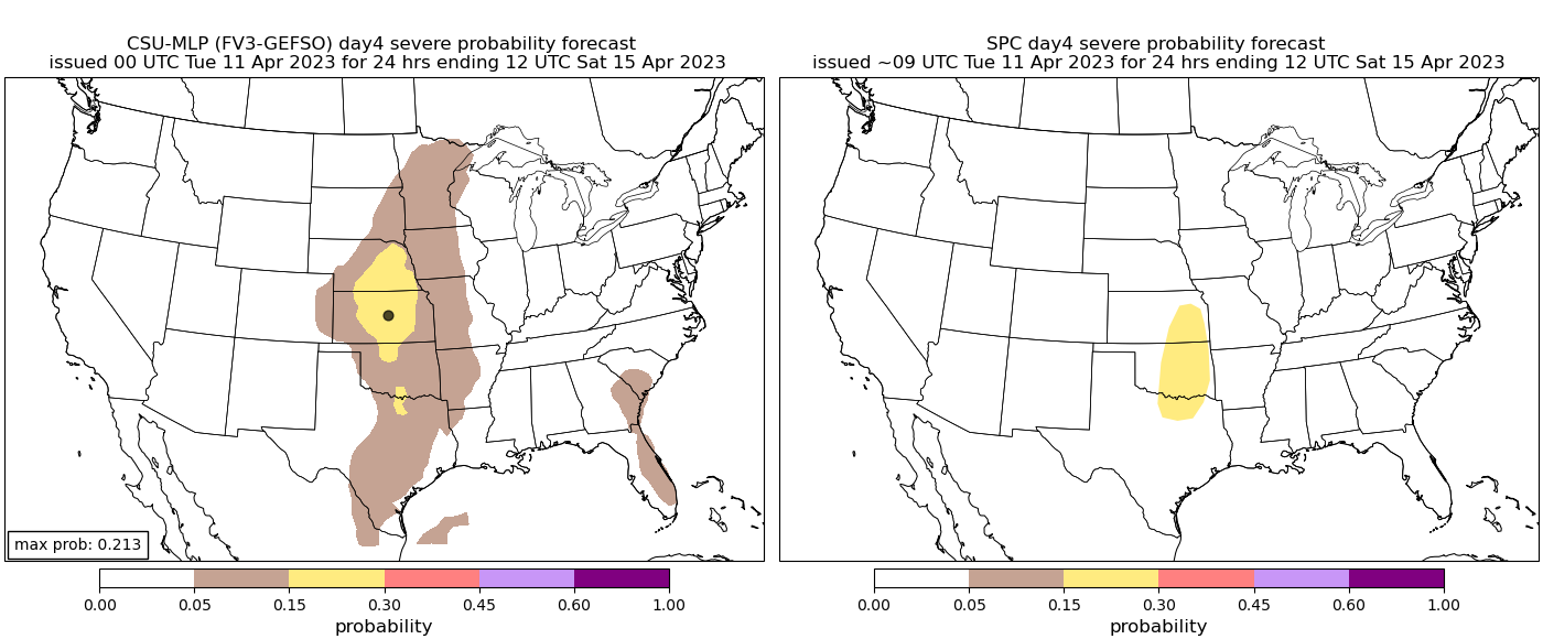
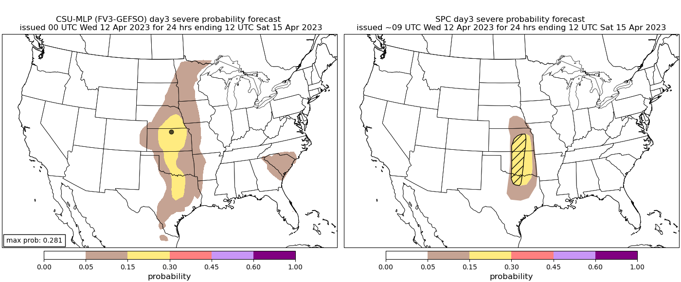
HERE IS A SLIGHT RISK OF SEVERE THUNDERSTORMS OVER SOUTHEAST
NEBRASKA...EASTERN KANSAS...AND NORTH-CENTRAL/CENTRAL OKLAHOMA...
...SUMMARY...
Severe thunderstorms capable of very large hail and damaging gusts
are possible over portions of southeast Nebraska, eastern Kansas,
and north-central/central Oklahoma on Friday.
...Southern and Central Plains...
Broad upper troughing is expected to be in place over the western
CONUS Friday morning. Several shortwave troughs will be embedded
within this larger-scale troughing, including one that is forecast
to eject into the central Plains during the late afternoon. A cold
front will be gradually moving southward across the central Plains.
Low-level moisture over the region will be modest, but strong
diurnal heating in tandem with ascent attendant to both the cold
front and approaching shortwave is expected to overcome any capping,
resulting in convective initiation. Storms are mostly likely from
central NE through central KS. Large hail, including some hail
greater than 2" in diameter, is possible with initial development.
Damaging gusts will then become possible as the storms generate
strong downdrafts.
A more conditional severe risk exists farther south into OK and TX,
where there is uncertainty on destabilization ahead of the dryline.
Most guidance keeps much of TX and OK free of thunderstorms. Even
so, there are some indications within the guidance that a more
subtle shortwave may move through the southern High Plains and into
OK and north TX during the late afternoon/early evening. As such,
will leave slight-risk-equivalent probabilities in north-central OK
for this outlook, while reducing probabilities across
central/south-central OK and north-central TX. If convective
initiation is realized, large hail and strong downbursts are
anticipated.
...Southern Appalachians into the Mid-Atlantic...
A shortwave trough will likely track northeastward from the AL/GA
vicinity into the Mid-Atlantic on Friday. An arcing band of warm-air
advection showers and thunderstorms will likely be ongoing over the
Carolinas early Friday, before gradually moving northward throughout
the day.
Modest low-level moisture will continue to advect northward in the
wake of the warm-air advection band, supporting afternoon airmass
destabilization ahead of this shortwave and a weak associated
surface low. As a result, additional thunderstorms are possible
during the afternoon and evening. Vertical shear will be strong
enough to support a few storms capable of damaging gusts and/or
hail.

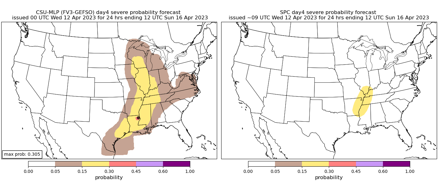
THERE IS A SLIGHT RISK OF SEVERE THUNDERSTORMS FROM THE MID
MISSISSIPPI VALLEY INTO FAR EAST TEXAS AND NORTHERN LOUISIANA...
...SUMMARY...
Severe thunderstorms capable of large to very large hail and
damaging gusts are possible from the Mid Mississippi Valley into far
East Texas and northern Louisiana on Saturday.
...Synopsis and Discussion...
An expansive cold front will likely extend from western WI
southwestward into the TX Hill Country early Saturday morning. This
front is forecast to make gradual eastward/southeastward progression
throughout the day, while low-level moisture increases ahead of it.
By Saturday afternoon, mid 60s dewpoints are possible as far north
as the Mid-South, with low 60s dewpoints reaching into central MO
and southern IL. Steep mid-level lapse rates will precede this front
from east TX into Mid MS Valley. Underlying capping will likely
prevent convective initiation through the morning and into the early
afternoon.
As the front is gradually progresses eastward, a shortwave trough
will be moving eastward across KS, OK, and north TX, and into the
Mid MS Valley. Large-scale ascent will increase ahead of this
shortwave from the Mid-South into the Mid MS Valley during the late
afternoon/early evening. At the same time, convective inhibition
along and ahead of the front will continue to erode amid persistent
low-level moisture advection and modest diurnal heating. This
weakening convective inhibition, coupled with increasing large-scale
ascent and lift along the front, is expected to result in
thunderstorm development along and ahead of the front, from the Mid
MS Valley down into the Arklatex and east TX.
Given the steep lapse rates and strong buoyancy, initial updrafts
should be quite strong and capable of both large hail (some
potentially very large) and damaging gusts. Severe potential is
expected to continue downstream during the evening and overnight as
the front continues to push eastward.


I see Monroe County MS is in the cross hairs again
Latest C-Shield 2-5km UH tracks
As of right now I have my target as Pine Bluff, Ark