• Welcome to TalkWeather!
    We see you lurking around TalkWeather! Take the extra step and join us today to view attachments, see less ads and maybe even join the discussion.
    CLICK TO JOIN TALKWEATHER

Severe WX April 11th-13th, 2020 Severe Weather Threat

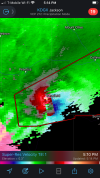
While we appreciate all viewpoints on TalkWeather, we are currently in a nowcasting situation with active warnings. Please keep the discussion flowing with current information and keep the model accuracy discussion for the post-event discussion. If you have issues with this feel free to shoot me a PM.
 
I'm looking at KDGX on GR2AE, and on the NROT product on the Tornado Emergency storm, I'm currently getting an NROT reading of 3.26. That's not something you'd encounter on many supercell storms.:eek:
 
Stay safe @Kory

THE NATIONAL WEATHER SERVICE IN BIRMINGHAM HAS ISSUED A

* TORNADO WARNING FOR...
NORTHWESTERN TUSCALOOSA COUNTY IN WEST CENTRAL ALABAMA...
SOUTHERN FAYETTE COUNTY IN WEST CENTRAL ALABAMA...

* UNTIL 515 PM CDT.
 
Cells in S MS are monstrous. Would watch for further major tornadoes from those, especially the lead cell as it tracks towards more populated areas (Laurel).
 
Stay safe @Kory

THE NATIONAL WEATHER SERVICE IN BIRMINGHAM HAS ISSUED A

* TORNADO WARNING FOR...
NORTHWESTERN TUSCALOOSA COUNTY IN WEST CENTRAL ALABAMA...
SOUTHERN FAYETTE COUNTY IN WEST CENTRAL ALABAMA...

* UNTIL 515 PM CDT.
Thanks Wes! Should pass just to my north. It is warm and humid outside...stiff S wind and lots of rolling thunder.
 
These idiots on twitter are amazing. Jason Simpson is taking a beating on twitter because he interrupted a golf classic from last year. WE KNOW WHO WON IT
Normally, I have a hard line about folks complaining about breaking into programming, but two stations in the Huntsville market have broken into programming with nothing more than a severe t'storm warning in their coverage area. They're talking more about Pickens County (which is clearly in the Birmingham market) than anything in their own market.

I wish I had started a count on how many times the mets on both channels have said the word "nothing".
 
Bassfield, MS isn't much of a town, but what little there is might not be there anymore. Goodness at that velocity image on that storm that just went over that town.
 
COVINGTON MS-JEFFERSON DAVIS MS-
414 PM CDT SUN APR 12 2020

...TORNADO EMERGENCY FOR LOCATIONS IN THE WARNED AREA...

...A TORNADO WARNING REMAINS IN EFFECT UNTIL 445 PM CDT FOR SOUTHERN
COVINGTON AND SOUTHEASTERN JEFFERSON DAVIS COUNTIES...

AT 414 PM CDT, A CONFIRMED LARGE AND DESTRUCTIVE TORNADO WAS LOCATED
NEAR CARSON, OR 13 MILES SOUTHWEST OF COLLINS, MOVING NORTHEAST AT 55
MPH.

TORNADO EMERGENCY FOR LOCATIONS IN THE WARNED AREA. THIS IS A
PARTICULARLY DANGEROUS SITUATION. TAKE COVER NOW!
 
I've only known a handful of Dixie outbreaks with well spaced discrete supercells. We just don't get that here. Not trying to be rude or anything with my post. Maybe I'm just annoyed with all of the Plains chasers complaining about it. Dixie Alley usually sees semi-discrete supercells mixed around junk.

Previous outbreaks are really irrelevant. The point that was made was that the most likely spot for isolated and discrete supercells in the immediate term is further to the south. That's an accurate description of what's currently occurring.

I think you guys are reading far too much into what was stated. It wasn't an exclusionary statement that the messier storm mode further north excludes an outbreak or that the threat has been mitigated. It's a simple truth that the current location of discrete cells is to the north. I believe that claim had caveats that the northern threat may ramp up later.

We're all on the same side here. I think we can all be more generous with the interpretations of each others posts and inquire if someone means what we read their post as saying.

Now, back to the event!
 
Back
Top