tennessee storm chaser
Member
- Messages
- 1,877
- Reaction score
- 4,288
- Location
- jackson tennessee
- Special Affiliations
- SKYWARN® Volunteer
Wow 12z euro has cape values up to 2000 pushing parts Missouri Arkansas next Wednesday…
Follow along with the video below to see how to install our site as a web app on your home screen.
Note: This feature may not be available in some browsers.
Yeah, you have widespread mid/upper 60 dewpoints that advect well inland over a large area and an upper-level pattern that favors a large EML plume advecting out overtop the warm sector. This will not be a low instability event.Wow 12z euro has cape values up to 2000 pushing parts Missouri Arkansas next Wednesday…
Think extreme west Tennessee Memphis area can get on the severe threat still? Or does this area get pinched off from the best instability ?Yeah, you have widespread mid/upper 60 dewpoints that advect well inland over a large area and an upper-level pattern that favors a large EML plume advecting out overtop the warm sector. This will not be a low instability event.
The eastern extent, no matter where it sets up, is not because of pinched off instability. It would be because of dynamics and large scale ascent pulling north away from the instability axis. But the Euro ensembles did not support the GFS/Euro today shifting north. The Euro ensemble mean was almost a full state south of the operational Euro with the upper low center for Wednesday evening. Until a more northward solution is fully locked in, instead of just being a back and forth trend, then the threat isn't removed for areas as far east as middle KY, middle TN, and north AL, much less west TN or north MS.Think extreme west Tennessee Memphis area can get on the severe threat still? Or does this area get pinched off from the best instability ?
At least as of the 18z GFS and the earlier 12z non-American models, mid-level winds are too weak along and east of the dryline in Kansas and especially Oklahoma... and they're the strongest on there of the different model solutions. Euro and Canadian are even weaker. 30-35 kt 0-6 km shear isn't going to cut it for supercell structures, especially long-tracked ones. You have to get back behind the dryline to get 40+ kt deep-layer shear, and 40 kts is on the marginal side of acceptable. Then, on the guidance with the highest dewpoints, you have LCL heights that are too high for significant tornadoes (1200-1400m) until you get substantially east of the dryline and out into the middle of the moisture axis... but away from lifting mechanisms and in an environment that doesn't have strong mid-level winds to take the dryline storms into those areas fast enough. And then after sunset, not only does it look like the boundary layer decouples because... while the dewpoints are in the low to mid 60s... there's too much of a dewpoint depression through sunset and the near-surface layer can do some radiational cooling right after sunset despite the wind fields, but also forecast soundings show that capping actually increases in strength along and out ahead of the dryline... and one of those things alone would've meant that any convection would be elevated as the nocturnal low-level jet increases, but both of them together seals the deal. So, even on the most favorable model output, you have a situation where composite parameters look scary because CAPE and SRH are high, but you have an environment with deep-layer shear too weak to support supercell structures and LCL heights too high to support significant tornadoes until after dark when the boundary layer decouples and capping increases so that storms can't take advantage of the strong low-level shear and increasing deep-layer shear.Still a little too far out to be fully confident, but Tuesday definitely has the potential to resemble some of the classic high-end early season central CONUS widespread (Oklahoma to Iowa) outbreaks of the past, like 3/13/90 and 4/26/91 (4/14/12 was another similar setup, but not quite that rough in the way it played out).


The past three EPS runs have also trended toward a deeper, lower-amplitude solution on Wednesday.Every 00z operational run aside from the GFS has some sort of significant severe weather episode across a large expanse of real estate on Wednesday, especially the UK.
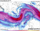
Should we see some further deamplification like occurred prior to several recent events, the ceiling increases. This 114 hr mean 500 mb flow and CAPE combo (18z Wednesday) from the CMC ensemble is pretty nuts.
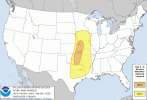
That is one large area shaded already day 5 risk …. Then got a decent size 30 percent marked already … could we be leading towards a first of the season high risk coming next week… if the euro is correct , I say there is a good solid chance we will see that.Well there we go... A 30% risk area for Days 4 & 5 (sorry if they are put in the wrong order). Day 5 especially contains some higher end wording :
"Even with lingering uncertainty regarding
the possible effect of early-day convection and some model
differences in the placement of the upper trough and related surface
features, enough confidence exists to include a 30% severe area for
parts of the ArkLaTex into the lower MS Valley and Mid-South. This
region appears to have the best chance for substantial
destabilization Wednesday afternoon and discrete supercells."
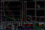
C OK looks slightly uncapped, and would be aided by the tight dryline modelled. Pulled this sounding from a SigTor Parameter bullseye on the model, and it does suggest a favourable environment with strong instability and favourable low-level shear, though upper level support is lackluster. Even with the strong dryline in places that remain capped, parcel residence times are relatively short and would probably be hard to initiate.Hmmmmm....NAM's first look at Tuesday afternoon/evening is not impressive. Soundings are pretty much capped across the board.
Lapse rates look slit better further south actually for Wednesday… think best tornado threat happens that day be honest day 5. I am already got plan to start central Arkansas then heads towards either very southern Missouri or nw MississippiC OK looks slightly uncapped, and would be aided by the tight dryline modelled. Pulled this sounding from a SigTor Parameter bullseye on the model, and it does suggest a favourable environment with strong instability and favourable low-level shear, though upper level support is lackluster. Even with the strong dryline in places that remain capped, parcel residence times are relatively short and would probably be hard to initiate.
Ukie. AlsoThe EURO/CMC continue to present a more severe episode than the GFS out of this event.
I think some of that is because it's likely underdoing surface warmth east of the dryline like it typically does in these WAA patterns. There would also be greater large scale ascent back closer to the trough, which is what lifts and weakens the EML's capping inversion on the larger scale. Barring capping concerns, the KS/OK portion of this isn't as much of a struggle bus for significant tornado potential late Tuesday along the dryline as maybe previously thought. Deep-layer shear has trended up a good bit across all models along and just ahead of the dryline for late day into the evening. It's now in the 40-45 kt range, which is what you'd expect for Plains supercells in a 3000+ CAPE environment. Dewpoints have also trended up a little more, and this has lowered LCL heights for the afternoon during peak heating and has decreased the odds of the boundary layer being able to decouple right at sunset as the low-level jet intensifies. There are just capping concerns. But over central OK into KS, there is pretty strong upward motion along the dryline in the lowest 1km or so, and heights are also falling in the afternoon and evening. If storms go through the cap 21-02z, they would have deep-layer shear supportive of them being supercells, LCLs supportive of tornadoes, and rich enough moisture combined with the sfc flow for them to stay rooted at the surface after dark as the nocturnal LLJ intensifies. I could see the 5pm-10pm timeframe being quite sketchy for the I-35 corridor of KS/OK. And the environment does seem to improve up into northwest MO and southwest IA closer to 00z as well. NAM and GFS both show that the cap breaks south of the warm front by then up into that area, and with better dewpoints that support lower LCLs for tornadoes to be a problem. It just may take until closer to 00z.Hmmmmm....NAM's first look at Tuesday afternoon/evening is not impressive. Soundings are pretty much capped across the board, except further south in C KS/OK. Kind of odd because usually with Plains setups you expect them to be more capped with southward extent.
I think some of that is because it's likely underdoing surface warmth east of the dryline like it typically does in these WAA patterns. There would also be greater large scale ascent back closer to the trough, which is what lifts and weakens the EML's capping inversion on the larger scale. Barring capping concerns, the KS/OK portion of this isn't as much of a struggle bus for significant tornado potential late Tuesday along the dryline as maybe previously thought. Deep-layer shear has trended up a good bit across all models along and just ahead of the dryline for late day into the evening. It's now in the 40-45 kt range, which is what you'd expect for Plains supercells in a 3000+ CAPE environment. Dewpoints have also trended up a little more, and this has lowered LCL heights for the afternoon during peak heating and has decreased the odds of the boundary layer being able to decouple right at sunset as the low-level jet intensifies. There are just capping concerns. But over central OK into KS, there is pretty strong upward motion along the dryline in the lowest 1km or so, and heights are also falling in the afternoon and evening. If storms go through the cap 21-02z, they would have deep-layer shear supportive of them being supercells, LCLs supportive of tornadoes, and rich enough moisture combined with the sfc flow for them to stay rooted at the surface after dark as the nocturnal LLJ intensifies. I could see the 5pm-10pm timeframe being quite sketchy for the I-35 corridor of KS/OK. And the environment does seem to improve up into northwest MO and southwest IA closer to 00z as well. NAM and GFS both show that the cap breaks south of the warm front by then up into that area, and with better dewpoints that support lower LCLs for tornadoes to be a problem. It just may take until closer to 00z.