snostorm21
Member
As far as I can tell, tornado still on the ground with that eastern cell.
Follow along with the video below to see how to install our site as a web app on your home screen.
Note: This feature may not be available in some browsers.
Yeah I think you’re right unfortunately. Was thinking for a minute that the same part of Adamsville hit in 2023 got spared, but that might not be the case. Terrible luck.As far as I can tell, tornado still on the ground with that eastern cell.

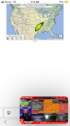
It’s entering a massive radar hole, going to be a while before any sort of clear data will be available of this supercell unless the tornado becomes exceptionally intense again.Yeah I think you’re right unfortunately. Was thinking for a minute that the same part of Adamsville hit in 2023 got spared, but that might not be the case. Terrible luck.
Nothing to choke this off

It is certainly well into the EF4 category.The selmer tornado is unsurprisingly a very high end tornado on the Emmerson intensity estimation scale at over 180mph EF4.
We’ll see what happened under the cover of night….once again…for the 500th time this decade.