snostorm21
Member
No words…
Follow along with the video below to see how to install our site as a web app on your home screen.
Note: This feature may not be available in some browsers.


Wasn't Selmer or Bethel Springs hit then too? I seem to remember one of those terrifying nighttime lightning flash tornado videos from this area.The southern edge of this event is scary; reminiscent of the tail end of 3/31/23 and really also 2/5/08. The big question today was storm mode and cell spacing, these two isolated cells down here are really maxing out their potential. Very very bad stuff.
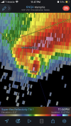
That’s an absolutely horrifying debris signature on the CC.
Yes there was a deadly long-tracked EF3 that went near Selmer, Bethel Springs, and Adamsville on 3/31/2023.Wasn't Selmer or Bethel Springs hit then too? I seem to remember one of those terrifying nighttime lightning flash tornado videos from this area.