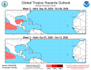
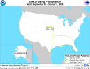
akt1985
Member
If the GFS forecast becomes true, at least, hopefully, it won’t be the I named storm.
Follow along with the video below to see how to install our site as a web app on your home screen.
Note: This feature may not be available in some browsers.
Next name actually is FayIf the GFS forecast becomes true, at least, hopefully, it won’t be the I named storm.


FWIW, 18ZGFS cane today is up out of the Caribbean across Cuba and the Bahamas, then an Atlantic fish.
View attachment 54927
ECMWF long range has no idea what the GFS is smoking.

0Z - nothingI for one hope the GFS fantasy storm doesn’t happen. It has the makings of a Hurricane that would get its name retired if it did happen as forecasted.

0Z - nothing
06Z - nightmare that rides up west coast of florida, pull out into the gulf, then hits the panhandle before getting stuck in the mountains Helene style.
12Z - nothing
And importantly, all this is 300+ hours out, and not getting closer each run. IMO, this is the GFS saying "well this is the right time of year for hurricanes, right? I should spit one out here in a couple of weeks."
In this case, because it's the only one showing something.I have no clue why people use the GFS for hurricanes. It's just not made for that.
I certainly wouldn't use it for that for real, I hope that much I made clear.
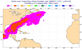

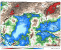
No sign of it. Euro's just modeling typical Gulf climate at 300+ and some knuckleheads on the internet used AI to push the (literally hour 360!) ECMWF map as if it has bearing to reality.So the GFS might come true after all?
It might become a brief tropical storm but not a hurricane. It's not a threat to the Caribbean or U.S. at all. Will stay out to sea and well away from any landmasses.What a wacky looking storm; that AL06(? sorry if that's incorrect; i'm still learning) one.
Please forgive me if this is a naive question but if it follows the currently predicted path could it at all...I dunno; get stronger? When it heads south I mean.
Again I apologise for my likely grade school-esque terminology, but I feel like that little turn gives it just a tiny bit more distance to potentially regain a bit of strength as it maybe brushes past the Caribbean and (potentially) loops back up along the coast of NA?
I'll refrain from apologising a fourth time; as hard to resist as it might be! X) So instead I'll just say thanks to anyone who entertains my rambling.