Morning look - Humberto opens an eye, and 94L remains a disorganized mess in Haiti.

Follow along with the video below to see how to install our site as a web app on your home screen.
Note: This feature may not be available in some browsers.


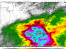
Well, 94L is definitely locked into impacting somewhere along the Atlantic Bight. Biggest questions are how strong it gets and what happens after landfall. Latest HAFS has it stalling out over Georgia.
One gets the feeling Humberto is about to overperform predictions. Maybe it will absorb 94L as it does.Ummmm
(At 5 am EST (my time), the core was fully built yet. Now at 10 am EST my time the eye appears to rapidly trying to clear out)
5 am this morning (about the time I woke up)
Now
Hopefully, if this occurs, it minimizes impacts from moisture in the mountains. The last thing that region needs is a Helene repeat.One gets the feeling Humberto is about to overperform predictions. Maybe it will absorb 94L as it does.
I really don't like saying this, but I am really concerned we're going to see exactly that - the stalling over N/GA scenario is nasty - it will pull Atlantic moisture into the mountains and orographic lift will squeeze it out.Hopefully, if this occurs, it minimizes impacts from moisture in the mountains. The last thing that region needs is a Helene repeat.


NHC will initiate advisories on Potential Tropical Cyclone Nine (formerly AL94), located near eastern Cuba, at 500 PM EDT (2100 UTC). |