
If anyone is looking for that "doomsday scenario" model output, GEFS member 6 is your guy. Rides the moisture up the FL peninsula and into the Carolina mountains. It's the ONLY one out of all of them though, so if I see someone post it as a prediction this far out I will personally hang you by your toenails and beat you into subconsciousness with a wet carp. It's one scenario out of 20. It does, however, remind us that yes, the possibility does exist.
Navigation
Install the app
How to install the app on iOS
Follow along with the video below to see how to install our site as a web app on your home screen.
Note: This feature may not be available in some browsers.
More options
-
Welcome to TalkWeather! We see you lurking around TalkWeather! Take the extra step and join us today to view attachments, see less ads and maybe even join the discussion. CLICK TO JOIN TALKWEATHER
You are using an out of date browser. It may not display this or other websites correctly.
You should upgrade or use an alternative browser.
You should upgrade or use an alternative browser.
2025 Atlantic Hurricane Season
- Thread starter Atlantic
- Start date
majorhurricane1703
Member
Fun story. I got ChatGPT (I have the paid version) to compile the past several years of mean track errors, based on the NHC verifications, and these are the results:
View attachment 45891
View attachment 45892
For Cape Verde-type storms specifically:
View attachment 45893
Moral of the story: It is entirely irresponsible for people to be touting this as an OTS storm at this point! We are BEYOND 7 days (closer to 8-10 days), and the models that far out are mostly climatology-driven anyway. It's simply way too soon, and no I'm not wishcasting and wanting a U.S. hit. I'm just saying -- yes, there's a good chance it goes OTS, but also a decent chance it doesn't, and we need to be factual and not comforting erroneously.
Very very interesting study! It tells you just how fickle the atmospheric setup is to changes when you have can an error of recurvature at 100 miles just over 2 days. Of course a lot of that could be due to the fact that I argue we’ve had tougher storms to forecast especially more so over the last 5 years then recent memory, but this gives a great perspective and reinforces your take at jumping to conclusions too soon.Fun story. I got ChatGPT (I have the paid version) to compile the past several years of mean track errors, based on the NHC verifications, and these are the results:
View attachment 45891
View attachment 45892
For Cape Verde-type storms specifically:
View attachment 45893
Moral of the story: It is entirely irresponsible for people to be touting this as an OTS storm at this point! We are BEYOND 7 days (closer to 8-10 days), and the models that far out are mostly climatology-driven anyway. It's simply way too soon, and no I'm not wishcasting and wanting a U.S. hit. I'm just saying -- yes, there's a good chance it goes OTS, but also a decent chance it doesn't, and we need to be factual and not comforting erroneously.
wx_guy
Member
- Messages
- 1,237
- Reaction score
- 4,443
- Location
- United States
- HAM Callsign
- KO4ZGH
- Special Affiliations
- SKYWARN® Volunteer
- ARRL Member
Loving ChatGPT 5! It took some coaxing and working with it, but I was able to feed it GFS model data lagged by 24 hours versus observed data today (at 0z, 6z, and 12z) to see how well it's doing so far:

It is generally further west and a bit south of where the GFS has been wanting it to go. For reference, the 0z forecast is 26 nm off, the 06z forecast is 53 nm off, and the 12z forecast is 80 nm off. And this is just the GFS from 24 hours ago. (I wanted to do the Euro too, but getting its raw model data is trickier and didn't bother.) EDIT: If the errors are extrapolated outward, this gives a 7-day error of about 800 miles. So yeah...
Just something to watch.
EDIT2: I was able to get the Euro's 24-lagged position from the Google WeatherLab page. The Euro is about 40 miles off (about half the error of the GFS). The storm is also further south and west than the Euro projected.
The question is if these early errors will propagate? If so, we may have a storm that is several hundred miles southwest of where the models are thinking 7-10 days from now...
Last edited:
majorhurricane1703
Member
Loving ChatGPT 5! It took some coaxing and working with it, but I was able to feed it GFS model data lagged by 24 hours versus observed data today (at 0z, 6z, and 12z) to see how well it's doing so far:
View attachment 45894
It is generally further west and a bit south of where the GFS has been wanting it to go. For reference, the 0z forecast is 26 nm off, the 06z forecast is 53 nm off, and the 12z forecast is 80 nm off. And this is just the GFS from 24 hours ago. (I wanted to do the Euro too, but getting its raw model data is trickier and didn't bother.) EDIT: If the errors are extrapolated outward, this gives a 7-day error of about 800 miles. So yeah...
Just something to watch.
EDIT2: I was able to get the Euro's 24-lagged position from the Google WeatherLab page. The Euro is about 40 miles off (about half the error of the GFS). The storm is also further south and west than the Euro projected.
The question is if these early errors will propagate? If so, we may have a storm that is several hundred miles southwest of where the models are thinking 7-10 days from now...
This is great stuff. If you can, please post this again tomorrow. I’d love to see what the updated disparity is between where the GFS projected the storm to be and where it is actually. I know 40 miles doesn’t sound like much in a 24 hour period with the Euro but these short term disparities can add up quick especially if Erin dips farther south than what the Euro might think as it moves across the Atlantic.
wx_guy
Member
- Messages
- 1,237
- Reaction score
- 4,443
- Location
- United States
- HAM Callsign
- KO4ZGH
- Special Affiliations
- SKYWARN® Volunteer
- ARRL Member
Yeah sure! I'm going to aim and do the same thing with the NHC forecast too. This will be a big alarm if there forecast is deviating too far north as well.This is great stuff. If you can, please post this again tomorrow. I’d love to see what the updated disparity is between where the GFS projected the storm to be and where it is actually. I know 40 miles doesn’t sound like much in a 24 hour period with the Euro but these short term disparities can add up quick especially if Erin dips farther south than what the Euro might think as it moves across the Atlantic.
Lake Martin EF4
Member
Erin's here! Quick! Call Esurance!
Really not liking that southwestward trend (compared to the Euro)!
Really not liking that southwestward trend (compared to the Euro)!
wx_guy
Member
- Messages
- 1,237
- Reaction score
- 4,443
- Location
- United States
- HAM Callsign
- KO4ZGH
- Special Affiliations
- SKYWARN® Volunteer
- ARRL Member
So I made ChatGPT's creation from earlier today into an app. It now is very customizable, and I can input ANY model that's in the NOAA A-Deck that's publicly available (which sadly doesn't include the Euro, but essentially every other one).
Here's the GFS deterministic at 18z today lagged 24 hours, at 6-hour intervals. The error is shown, with the model in red and the observed track in green.

And the GEFS ensemble mean:

The HCCA from FSU's supercomputer:

HAFS-A:

HAFS-B:

TVCN -

So really it looks like the HAFS-A and HAFS-B are doing the best right now overall? Will keep a watch on trends.
EDIT: Looks like I found a more accurate model, the CEMN, the Canadian ensemble. Really surprising finding. Let's see if it can continue the trends.

Here's the GFS deterministic at 18z today lagged 24 hours, at 6-hour intervals. The error is shown, with the model in red and the observed track in green.
And the GEFS ensemble mean:
The HCCA from FSU's supercomputer:
HAFS-A:
HAFS-B:
TVCN -
So really it looks like the HAFS-A and HAFS-B are doing the best right now overall? Will keep a watch on trends.
EDIT: Looks like I found a more accurate model, the CEMN, the Canadian ensemble. Really surprising finding. Let's see if it can continue the trends.
Last edited:
- Thread starter
- #888
wx_guy
Member
- Messages
- 1,237
- Reaction score
- 4,443
- Location
- United States
- HAM Callsign
- KO4ZGH
- Special Affiliations
- SKYWARN® Volunteer
- ARRL Member
Yeah, the discussion on X is a buzz right now. Not just the GFS, but all of the 18z models have shifted further south and west. The HAFS-A and HAFS-B now show the hurricane hitting (or at least clipping) the Antilles as a major hurricane.It seems by at least 00Z August 19th in the 18Z GFS, that it has (for this run at least) trended way more to the south than at the same time on the 12Z GFS run
- Thread starter
- #890
See what we mean though, if it continues to trend more south we will have to watch it even more closely. I said this before and I’ll say it again: it really does have a bunch of similarities Irma, even if it may not be a carbon-copy of Irma in the end.Yeah, the discussion on X is a buzz right now. Not just the GFS, but all of the 18z models have shifted further south and west. The HAFS-A and HAFS-B now show the hurricane hitting (or at least clipping) the Antilles as a major hurricane.
Just keep your eyes peeled and your ears open.
majorhurricane1703
Member
In my humble opinion I think more shifts south will come. A lot of times when you see shifts they follow a trend back in the other direction. Not saying that will definitely happen but something to watch for.Yeah, the discussion on X is a buzz right now. Not just the GFS, but all of the 18z models have shifted further south and west. The HAFS-A and HAFS-B now show the hurricane hitting (or at least clipping) the Antilles as a major hurricane.
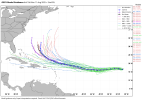
If y'all notice on the 18z GFS Ensemble tracks, there's a handful that take it further west and track between Cuba/Florida. Not much, but it's something to watch. Erin is gonna have a tough time intensifying during the next 5 days or so due to it literally slamming against a wall of dry air. However, since it's moving west at a pretty good clip, it may be able to fend off the dry air especially if can build a good coherent thunderstorm cluster around the center like Beryl did last year. Unless something drastic happens, though, this won't be intensifying quickly.
Weaker storm stays=further west
Weaker storm stays=further west
Attachments
tornado examiner
Member
I wonder how pretty Erin will be when it makes it to major status hopefully in the middle of nowhere.
What are we thinking? Mega donut or pinhole eye?
What are we thinking? Mega donut or pinhole eye?
N0mz
Member
00z run is a little bit concerning. Not a ring the alarm bell situation by any means but definitely something. Quit a bit more southwest than 18z which i believe was still more southwest of the 12z run
KakashiHatake2000
Member


I’m not sure if this would be the 00z run
N0mz
Member


12z vs 00z
wx_guy
Member
- Messages
- 1,237
- Reaction score
- 4,443
- Location
- United States
- HAM Callsign
- KO4ZGH
- Special Affiliations
- SKYWARN® Volunteer
- ARRL Member
The storm's center has drifted west-SOUTH-west over the past 6-8 hours and currently lies very close to 17 N. The 11 AM advisory from Monday morning has it around 17.4 or 17.5 N at this time, and the 11 PM advisory has it at 17.4 N at 8 AM this morning (Tuesday). That's approximately a 30 nautical miles or about 35 actual miles further south than forecast just 12/18 hours ago. I can only imagine this will *further* push the models to the south and west.
EDIT: The 2 AM best track is out and it still has the center at 17.5 N...hmmm,,,,on satellite, that looks way too far north, but maybe the LLC is near the top of the convection *shrugs*
EDIT: The 2 AM best track is out and it still has the center at 17.5 N...hmmm,,,,on satellite, that looks way too far north, but maybe the LLC is near the top of the convection *shrugs*
Last edited:
N0mz
Member

00z GEFS is a mixed bag, shows more southern tracks, although they almost all recurve, just later. BUT has two major major impacts in SC and NC
wx_guy
Member
- Messages
- 1,237
- Reaction score
- 4,443
- Location
- United States
- HAM Callsign
- KO4ZGH
- Special Affiliations
- SKYWARN® Volunteer
- ARRL Member
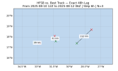
Here's the HAFS-A and HAFS-B 24-hour error plots -- pretty darn good! These hurricane models are nailing this storm so far.


And their 48-hour lag is great too, barring the first one when the circulation wasn't well-defined yet.


But the Official forecast is still King (only has 12-hour lag currently because the official forecast hasn't existed 24 hours yet):

Will try to keep posting these model verifications as we go, so we can see which models are grasping with this storm the best. I'll also start doing intensity verifications too, once the storm resumes strengthening.
And their 48-hour lag is great too, barring the first one when the circulation wasn't well-defined yet.
But the Official forecast is still King (only has 12-hour lag currently because the official forecast hasn't existed 24 hours yet):
Will try to keep posting these model verifications as we go, so we can see which models are grasping with this storm the best. I'll also start doing intensity verifications too, once the storm resumes strengthening.
Attachments
CheeselandSkies
Member
Erin probably deserves its own thread at this point...will probably have impacts somewhere down the line even without a direct landfall. It's also already had impacts in Cabo Verde before being named.