- Thread starter
- #821
Navigation
Install the app
How to install the app on iOS
Follow along with the video below to see how to install our site as a web app on your home screen.
Note: This feature may not be available in some browsers.
More options
-
Welcome to TalkWeather! We see you lurking around TalkWeather! Take the extra step and join us today to view attachments, see less ads and maybe even join the discussion. CLICK TO JOIN TALKWEATHER
You are using an out of date browser. It may not display this or other websites correctly.
You should upgrade or use an alternative browser.
You should upgrade or use an alternative browser.
2025 Atlantic Hurricane Season
- Thread starter Atlantic
- Start date
- Thread starter
- #822
Lake Martin EF4
Member
Don't rule out a US impact by any means. Even if it looks OTS initially, it could indeed end up impacting the Eastern US later down the road. Remember Florence?
Lake Martin EF4
Member
Dexter was pretty close, actually, except not in the MDR.
Erin, if indeed it is 97L, could be a fish but is likely going to be far stronger than a C1 unless something unexpected happens.
- Thread starter
- #825
Indeed. I’m not completely sold on a recurve quite yet.Don't rule out a US impact by any means. Even if it looks OTS initially, it could indeed end up impacting the Eastern US later down the road. Remember Florence?
- Thread starter
- #826
This guidance on 97L is crazy;
Here is the main track guidance as of now on 97L:
View attachment IMG_4431.png
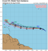
I’m seeing hints on this model track guidance just above for a sight southward dip before resuming a more westward direction again later on. Obviously this is subject to change but I thought it was interesting.

Here is the main track guidance as of now on 97L:
View attachment IMG_4431.png

I’m seeing hints on this model track guidance just above for a sight southward dip before resuming a more westward direction again later on. Obviously this is subject to change but I thought it was interesting.
wx_guy
Member
- Messages
- 1,237
- Reaction score
- 4,443
- Location
- United States
- HAM Callsign
- KO4ZGH
- Special Affiliations
- SKYWARN® Volunteer
- ARRL Member
Despite many on social media already writing 97L off as a fish storm, there's still a long way to go to figure that out. We likely won't know where it'll go for another 4-6 days. Irma comes to mind as a storm the models were consistently wrong on with its northward turn, even up to the point of the eventual FL landfall.
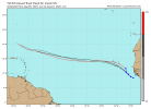
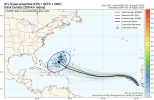
The plot below shows EPS + GEFS + CMC ensembles all together, and the ellipse is a probabilistic ellipse -- this shows that we can NOT rule out a further south track yet. Yes, the "middle" of the plot shows a turn to the north, which is important to understand. But the ellipse is showing all plausible tracks, and a Bahamas-oriented track is still possible.
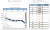
To reiterate this, it's important to see that beyond 72 hours, the ensemble spread has Low confidence, statistically speaking. This means beyond 3 days, the models currently shouldn't even be trusted really. We just don't have enough confidence to know.
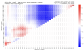
An interesting analysis is the correlation between longitude and latitude over time. Notice that using all available ensembles, there's a big blue patch -- what this is saying is that there's a moderate correlation between the westward extent 97L gets over the next 4-6 days and the eventual northward extent in 5-8 days. This is something to watch definitely, because it looks like, given the current models, that a further westward push over the 4-6 day timeframe results in a more southerly storm 5-8 days out -- this is important! Let's keep a watch on this.
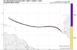
In this vein, looking at the models 24 hours ago (0z on the 9th), 12 hours ago (12z on the 9th), and currently (at 0z today), you see little change overall, but interestingly -- it DOES show a further west (and bit south) extent at 7-8 days from now. It's a small change, but if we see that trend continuing, that will have big results further downstream.
Ultimately, it's really silly to write this storm off already -- climatologically, it is probabilistically favored to recurve, but probability is not something to bank on! It's still way too soon to know the eventual destination of 97L, and all attention should still absolutely be on it.
The plot below shows EPS + GEFS + CMC ensembles all together, and the ellipse is a probabilistic ellipse -- this shows that we can NOT rule out a further south track yet. Yes, the "middle" of the plot shows a turn to the north, which is important to understand. But the ellipse is showing all plausible tracks, and a Bahamas-oriented track is still possible.

To reiterate this, it's important to see that beyond 72 hours, the ensemble spread has Low confidence, statistically speaking. This means beyond 3 days, the models currently shouldn't even be trusted really. We just don't have enough confidence to know.

An interesting analysis is the correlation between longitude and latitude over time. Notice that using all available ensembles, there's a big blue patch -- what this is saying is that there's a moderate correlation between the westward extent 97L gets over the next 4-6 days and the eventual northward extent in 5-8 days. This is something to watch definitely, because it looks like, given the current models, that a further westward push over the 4-6 day timeframe results in a more southerly storm 5-8 days out -- this is important! Let's keep a watch on this.

In this vein, looking at the models 24 hours ago (0z on the 9th), 12 hours ago (12z on the 9th), and currently (at 0z today), you see little change overall, but interestingly -- it DOES show a further west (and bit south) extent at 7-8 days from now. It's a small change, but if we see that trend continuing, that will have big results further downstream.

Ultimately, it's really silly to write this storm off already -- climatologically, it is probabilistically favored to recurve, but probability is not something to bank on! It's still way too soon to know the eventual destination of 97L, and all attention should still absolutely be on it.
Red on the map, 40% and 80% 2-day and 7-day odds, respectively. Could be a problem for the Caribbean, regardless of possible CONUS impacts, and still has to cross over Cape Verde.
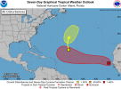
1. Eastern Tropical Atlantic (AL97):
Updated: Recently received satellite-derived wind data indicate
that a well-defined low pressure system has formed about midway
between the west coast of Africa and the Cabo Verde Islands with
maximum winds of about 35 mph. Although the associated shower and
thunderstorm activity still lacks some organization, only a small
increase in the organization could lead to the formation of a
tropical depression before the low moves near or across the Cabo
Verde Islands tonight and on Monday. Regardless of development,
locally heavy rainfall and gusty winds are possible today and Monday
across the Cabo Verde Islands, and interests there should monitor
the progress of this system.
Even if a tropical depression does not form over the next day or so,
environmental conditions appear conducive for later development,
and a tropical depression is likely to form by the middle to latter
portion of this week while moving west-northwestward at 15 to 20 mph
across the eastern and central tropical Atlantic.
* Formation chance through 48 hours...medium...40 percent.
* Formation chance through 7 days...high...80 percent.

wx_guy
Member
- Messages
- 1,237
- Reaction score
- 4,443
- Location
- United States
- HAM Callsign
- KO4ZGH
- Special Affiliations
- SKYWARN® Volunteer
- ARRL Member
I mentioned Irma in my post above, but this track also reminds me of Hurricane Andrew. Of course, different scenarios and such, but that's another case early guidance had it recurving, then the building High came more into focus and it was more obvious on a westerly track.Red on the map, 40% and 80% 2-day and 7-day odds, respectively. Could be a problem for the Caribbean, regardless of possible CONUS impacts, and still has to cross over Cape Verde.
View attachment 45813
Great post. I definitely agree with the sentiment that it’s got quite an Irma-like track in its near future, starting by moving NW first then dipping into the middle of the MDR after the fact. No one should be writing off this storm yet, not until that northward turn is within a 5-6 days of occurring IMO.Despite many on social media already writing 97L off as a fish storm, there's still a long way to go to figure that out. We likely won't know where it'll go for another 4-6 days. Irma comes to mind as a storm the models were consistently wrong on with its northward turn, even up to the point of the eventual FL landfall.
The plot below shows EPS + GEFS + CMC ensembles all together, and the ellipse is a probabilistic ellipse -- this shows that we can NOT rule out a further south track yet. Yes, the "middle" of the plot shows a turn to the north, which is important to understand. But the ellipse is showing all plausible tracks, and a Bahamas-oriented track is still possible.
To reiterate this, it's important to see that beyond 72 hours, the ensemble spread has Low confidence, statistically speaking. This means beyond 3 days, the models currently shouldn't even be trusted really. We just don't have enough confidence to know.
An interesting analysis is the correlation between longitude and latitude over time. Notice that using all available ensembles, there's a big blue patch -- what this is saying is that there's a moderate correlation between the westward extent 97L gets over the next 4-6 days and the eventual northward extent in 5-8 days. This is something to watch definitely, because it looks like, given the current models, that a further westward push over the 4-6 day timeframe results in a more southerly storm 5-8 days out -- this is important! Let's keep a watch on this.
In this vein, looking at the models 24 hours ago (0z on the 9th), 12 hours ago (12z on the 9th), and currently (at 0z today), you see little change overall, but interestingly -- it DOES show a further west (and bit south) extent at 7-8 days from now. It's a small change, but if we see that trend continuing, that will have big results further downstream.
Ultimately, it's really silly to write this storm off already -- climatologically, it is probabilistically favored to recurve, but probability is not something to bank on! It's still way too soon to know the eventual destination of 97L, and all attention should still absolutely be on it.
- Thread starter
- #831
To me, I’m seeing so many similarities to early Irma on this.Despite many on social media already writing 97L off as a fish storm, there's still a long way to go to figure that out. We likely won't know where it'll go for another 4-6 days. Irma comes to mind as a storm the models were consistently wrong on with its northward turn, even up to the point of the eventual FL landfall.
The plot below shows EPS + GEFS + CMC ensembles all together, and the ellipse is a probabilistic ellipse -- this shows that we can NOT rule out a further south track yet. Yes, the "middle" of the plot shows a turn to the north, which is important to understand. But the ellipse is showing all plausible tracks, and a Bahamas-oriented track is still possible.
View attachment 45807
To reiterate this, it's important to see that beyond 72 hours, the ensemble spread has Low confidence, statistically speaking. This means beyond 3 days, the models currently shouldn't even be trusted really. We just don't have enough confidence to know.
View attachment 45808
An interesting analysis is the correlation between longitude and latitude over time. Notice that using all available ensembles, there's a big blue patch -- what this is saying is that there's a moderate correlation between the westward extent 97L gets over the next 4-6 days and the eventual northward extent in 5-8 days. This is something to watch definitely, because it looks like, given the current models, that a further westward push over the 4-6 day timeframe results in a more southerly storm 5-8 days out -- this is important! Let's keep a watch on this.
View attachment 45809
In this vein, looking at the models 24 hours ago (0z on the 9th), 12 hours ago (12z on the 9th), and currently (at 0z today), you see little change overall, but interestingly -- it DOES show a further west (and bit south) extent at 7-8 days from now. It's a small change, but if we see that trend continuing, that will have big results further downstream.
View attachment 45810
Ultimately, it's really silly to write this storm off already -- climatologically, it is probabilistically favored to recurve, but probability is not something to bank on! It's still way too soon to know the eventual destination of 97L, and all attention should still absolutely be on it.
Irma
- GFS was trending weaker and OTS
- The disturbance hooked a right turn around the CV islands and became a TD just west of them.
- Irma formed in the month of August
- Models were suggesting a strong storm overall.
- Models hinted at a slight SW dive while approaching the Lesser Antilles
With 97L, it is very similar:
- GFS trending weaker and OTS in the short term
- The disturbance has hooked a left turn around the islands to date
- Models are hinting at a slight dive to the south but earlier on.
- It’s the month of August, the same month Irma formed in
- Thread starter
- #832
wx_guy
Member
- Messages
- 1,237
- Reaction score
- 4,443
- Location
- United States
- HAM Callsign
- KO4ZGH
- Special Affiliations
- SKYWARN® Volunteer
- ARRL Member
Yeah, it's those kinds of deviations that will matter a whole lot when amplified over 1000 miles headed towards the mainland. Definitely has my attention.@wx_guy the newest track trend seems to have shifted northwards in short term near the CV islands, but southwards out in the central MDR.
View attachment 45814
- Thread starter
- #834
I’m not sure if I should start the thread yet or not. My concern level is high on this one to say the least.Yeah, it's those kinds of deviations that will matter a whole lot when amplified over 1000 miles headed towards the mainland. Definitely has my attention.
My one concern stopping me from starting a thread right now if whether it will impact the U.S or go OTS.
wx_guy
Member
- Messages
- 1,237
- Reaction score
- 4,443
- Location
- United States
- HAM Callsign
- KO4ZGH
- Special Affiliations
- SKYWARN® Volunteer
- ARRL Member
We won't know that for another week-ish probably, and it's likely to be a significant hurricane either way. I suspect it'll generate a good bit of conversation, even if it eventually does go out to sea, so I say a thread might be justified -- but maybe wait until it's a TD or TS. I'm certain this will become Erin, but I'm always "meh" when someone makes a thread on an Invest haha lol up to you, though!I’m not sure if I should start the thread yet or not. My concern level is high on this one to say the least.
My one concern stopping me from starting a thread right now if whether it will impact the U.S or go OTS.
wx_guy
Member
- Messages
- 1,237
- Reaction score
- 4,443
- Location
- United States
- HAM Callsign
- KO4ZGH
- Special Affiliations
- SKYWARN® Volunteer
- ARRL Member
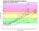
Posted just for reference and future: HAFS-A at 6z today shows a Cat 3-ish storm just above 20 N northeast of the islands, moving slightly south of WNW.
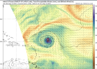
The HAFS-B has a solid Cat 3/4 at almost the same latitude as the HAFS-A and slightly more east, but virtually in the same location. This time, it is moving a jog north of due west.
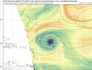
Curious to how this trends.

The HAFS-B has a solid Cat 3/4 at almost the same latitude as the HAFS-A and slightly more east, but virtually in the same location. This time, it is moving a jog north of due west.

Curious to how this trends.
- Thread starter
- #837
I have decided to wait at least 2-3 more days before I will know if I need to or not.We won't know that for another week-ish probably, and it's likely to be a significant hurricane either way. I suspect it'll generate a good bit of conversation, even if it eventually does go out to sea, so I say a thread might be justified -- but maybe wait until it's a TD or TS. I'm certain this will become Erin, but I'm always "meh" when someone makes a thread on an Invest haha lol up to you, though!
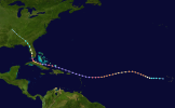
The other storm that comes to mind too is Hurricane Florence in 2018. It developed pretty much in the same area and was suppose to out to sea. Using NOAA Historical Hurricane Track There are 112 total storms that formed out of waves the came off where Invest 97L is now.
Some notable storms that came off in the same general vicinity:
Hugo 1989
Florence 2018
Fran 1996
Unnamed 1947
Gloria 1985
My take: I don't trust this going out to sea nor going up the East Coast given this hasn't developed yet. Invest 97L ends up further west.
Some notable storms that came off in the same general vicinity:
Hugo 1989
Florence 2018
Fran 1996
Unnamed 1947
Gloria 1985
My take: I don't trust this going out to sea nor going up the East Coast given this hasn't developed yet. Invest 97L ends up further west.
wx_guy
Member
- Messages
- 1,237
- Reaction score
- 4,443
- Location
- United States
- HAM Callsign
- KO4ZGH
- Special Affiliations
- SKYWARN® Volunteer
- ARRL Member
In theory, this is a perfect situation where the AI models should help discriminate against -- they sample the atmosphere and essentially find analogs going back in time, so if this storm were to either go OTS or inland, the AI models, should, at least in theory, be able to detect that earlier than the deterministic models, assuming their entire premise has an real promise to it. Granted, I doubt ANY model is reliable 14 days out due to the chaotic nature of our planet's physics, but I would hope at least that the AI models could discern this dichotomy before the deterministic models hone in on convergence themselves.The other storm that comes to mind too is Hurricane Florence in 2018. It developed pretty much in the same area and was suppose to out to sea. Using NOAA Historical Hurricane Track There are 112 total storms that formed out of waves the came off where Invest 97L is now.
Some notable storms that came off in the same general vicinity:
Hugo 1989
Florence 2018
Fran 1996
Unnamed 1947
Gloria 1985
My take: I don't trust this going out to sea nor going up the East Coast given this hasn't developed yet. Invest 97L ends up further west.
- Thread starter
- #840
There’s this recently:The other storm that comes to mind too is Hurricane Florence in 2018. It developed pretty much in the same area and was suppose to out to sea. Using NOAA Historical Hurricane Track There are 112 total storms that formed out of waves the came off where Invest 97L is now.
Some notable storms that came off in the same general vicinity:
Hugo 1989
Florence 2018
Fran 1996
Unnamed 1947
Gloria 1985
My take: I don't trust this going out to sea nor going up the East Coast given this hasn't developed yet. Invest 97L ends up further west.
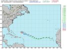
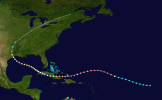
That’s a dip to the south slightly, which famously storms like Ike or more famously Irma have taken at some point in their lifetime.
Ike:
Irma:
