
Navigation
Install the app
How to install the app on iOS
Follow along with the video below to see how to install our site as a web app on your home screen.
Note: This feature may not be available in some browsers.
More options
-
Welcome to TalkWeather! We see you lurking around TalkWeather! Take the extra step and join us today to view attachments, see less ads and maybe even join the discussion. CLICK TO JOIN TALKWEATHER
You are using an out of date browser. It may not display this or other websites correctly.
You should upgrade or use an alternative browser.
You should upgrade or use an alternative browser.
wx_guy
Member
- Messages
- 1,237
- Reaction score
- 4,443
- Location
- United States
- HAM Callsign
- KO4ZGH
- Special Affiliations
- SKYWARN® Volunteer
- ARRL Member
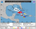
We now have Patty in the North Atlantic, and the Caribbean spot is up to 60/80


wx_guy
Member
- Messages
- 1,237
- Reaction score
- 4,443
- Location
- United States
- HAM Callsign
- KO4ZGH
- Special Affiliations
- SKYWARN® Volunteer
- ARRL Member
The 12z hurricane models (especially the two HAFS) are coming in HOT for 97L...the HAFS pair want to take this to near Cat 5 strength before it slams into Cuba.
- Thread starter
- #506
That is a concern as the Caribbean is still very warm. The only November Category 5 in the Atlantic was the 1932 Cuba Hurricane. Of course, I still believe that Iota (2020) was a category 5 for at least a brief time.The 12z hurricane models (especially the two HAFS) are coming in HOT for 97L...the HAFS pair want to take this to near Cat 5 strength before it slams into Cuba.

wx_guy
Member
- Messages
- 1,237
- Reaction score
- 4,443
- Location
- United States
- HAM Callsign
- KO4ZGH
- Special Affiliations
- SKYWARN® Volunteer
- ARRL Member
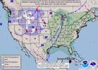
Curious about the westward track on the official cone, whereas much of the guidance wants to have it turn north towards the Panhandle.PTC 18 has formed east of Nicaragua.
View attachment 31320
- Thread starter
- #509
Zeta might be a good analog for future Rafael. A friend of mine brought up Zeta 2020 this afternoon and it really intrigued me.
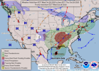
So here's what the WPC has for Tuesday currently with Rafael south of Cuba with frontal system near MS River and how the WPC map from October 28th, 2020 looked with Zeta. Both this one and Zeta had frontal systems involved in the mix.
You may ask well that frontal system should push Rafael more towards Florida and be a Florida landfall. Which could still happen. I'm not discounting anything yet, but two key takeaways from NWS Memphis afternoon discussion show how this ends up further west (not to Texas though):
1. The front is expected to stall across the region through late
week, as the main trough dampens and lifts northeast of the
region. Deep southwesterly flow will setup across the region on
Thursday in response to another deepening trough over the Four
Corners Region. The stalled front will back north of the region
on Thursday.
2. This system`s track will need to be closely monitored, as it has the
potential to interact with a mid-latitude cyclone in the Lower
Mississippi Valley next weekend. Both Ensemble and Deterministic
guidance suggest that tropical moisture will interact with a
frontal boundary over the Mid-South next weekend. Significant
rainfall could occur over portions of the Mid-South as PWATs climb
above 2 inches. Stay tuned.
Attachments

- Thread starter
- #511
Rafael I believe is gonna be similar to what we saw happen with Gordon 2018 at landfall on the Gulf coast. NHC has it nearing the Southeast Louisiana coast by Sunday. It's not going to Texas and it can only trend so far east due to HP (High Pressure) blocking. What I sent to my meteorology chat group this morning: So let's say that it hits southeast Louisiana Sunday or early next week. It'll be dealing with shear on landfall approach meaning Rafael will be east side weighted with everything on the east side. Meaning that a Southeast Louisiana landfall would put coastal MS and Alabama in the highest risk for impacts.
Attachments
- Thread starter
- #513
Yeah. Don't be surprised if this goes rapid deepening before it reaches Cuba. Favorable MJO, weak shear, and very warm SST. You can't ask for a better atmospheric environment for RI.
slenker
Member
Really impressed with how quickly that eye consolidated. Wouldn't be surprised if this thing hits strong category 2 before landfall.Yeah. Don't be surprised if this goes rapid deepening before it reaches Cuba. Favorable MJO, weak shear, and very warm SST. You can't ask for a better atmospheric environment for RI.
TornadoFan
Member
TornadoFan
Member
And we officially have Hurricane Rafael