• Welcome to TalkWeather!
    We see you lurking around TalkWeather! Take the extra step and join us today to view attachments, see less ads and maybe even join the discussion.
    CLICK TO JOIN TALKWEATHER

2021 Tropical Storm and Hurricane Season

WesL

"Bill, I'm talkin' imminent rueage"
Staff member
Administrator
Moderator
Sustaining Member
Messages
3,344
Reaction score
2,614
Location
Fayetteville, AR
Special Affiliations
  1. SKYWARN® Volunteer
Welcome one and all. Let's see what 2021 has in store for us this year.

Here are the 2021 names.
  • Ana (unused)
  • Bill (unused)
  • Claudette (unused)
  • Danny (unused)
  • Elsa (unused)
  • Fred (unused)
  • Grace (unused)
  • Henri (unused)
  • Ida (unused)
  • Julian (unused)
  • Kate (unused)
  • Larry (unused)
  • Mindy (unused)
  • Nicholas (unused)
  • Odette (unused)
  • Peter (unused)
  • Rose (unused)
  • Sam (unused)
  • Teresa (unused)
  • Victor (unused)
  • Wanda (unused)
 
  • Like
Reactions: KoD

Mike S

Administrator
Staff member
Administrator
Moderator
PerryW Project Supporter
Messages
1,991
Reaction score
1,115
Location
Meridianville, Al
Special Affiliations
  1. SKYWARN® Volunteer
So is the GFS on to something in the Gulf of Mexico for next weekend?
 

TH2002

Member
Sustaining Member
Messages
3,116
Reaction score
4,677
Location
California, United States
Special Affiliations
  1. SKYWARN® Volunteer
Chance of cyclone formation for the GOM disturbance is back down to 30% as the low moves inland while the Atlantic low is declared to have developed subtropical characteristics with advisories beginning later this morning
 
Messages
44
Reaction score
42
Location
Woodstock, GA
According to ATCF/Best Track, we have a 40kt Subtropical Storm Ana out in the North Atlantic, as Invest 90L finally developed central convection.

As for Invest 91L, it started firing off some decent convection while it was making landfall tonight, seemingly forgetting to do so for the past 24 hours until it was too late lol
 

TH2002

Member
Sustaining Member
Messages
3,116
Reaction score
4,677
Location
California, United States
Special Affiliations
  1. SKYWARN® Volunteer
600px-Ana_20210522_1200Z.png

144847_5day_cone_no_line_and_wind.png
 

Taylor Campbell

Moderator
Moderator
PerryW Project Supporter
Messages
2,102
Reaction score
2,189
Location
Wedowee, AL
Special Affiliations
  1. SKYWARN® Volunteer
There’s potential development showing in the models 10-14 days in the Gulf of Mexico.
 

WesL

"Bill, I'm talkin' imminent rueage"
Staff member
Administrator
Moderator
Sustaining Member
Messages
3,344
Reaction score
2,614
Location
Fayetteville, AR
Special Affiliations
  1. SKYWARN® Volunteer

Mike S

Administrator
Staff member
Administrator
Moderator
PerryW Project Supporter
Messages
1,991
Reaction score
1,115
Location
Meridianville, Al
Special Affiliations
  1. SKYWARN® Volunteer
It seems awfully early to be watching waves coming off the coast of Africa

1623673282593.png

NHC doesn't seem to think it will have a long lifespan

3. A strong tropical wave just offshore of west Africa is producing
disorganized shower and thunderstorm activity. Some development
of this system is possible during the next few days before a
combination of dry air aloft and strong upper-level winds limit any
chance of formation while the wave is over the central tropical
Atlantic Ocean late week.
* Formation chance through 48 hours...low...10 percent.
* Formation chance through 5 days...low...20 percent.
 

Mike S

Administrator
Staff member
Administrator
Moderator
PerryW Project Supporter
Messages
1,991
Reaction score
1,115
Location
Meridianville, Al
Special Affiliations
  1. SKYWARN® Volunteer
todays TWO mentions a disturbance off the Georgia/South Carolina coast that could possibly reach TS strength by landfall tomorrow night. Recon is scheduled for tomorrow.

There's also a wave over the eastern Atlantic they are watching. Chances of development are low.

Per NHC:

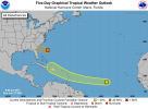
1. A small low pressure system is located about 425 miles
east-southeast of Savannah, Georgia. The associated shower and
thunderstorm activity has become less organized since earlier this
afternoon, becoming displaced to the northwest of the surface center
due to strong upper-level winds. The low is forecast to move
quickly west-northwestward at 15 to 20 mph, crossing over the
warmer waters of the Gulf Stream Monday morning, and it has some
potential to become a tropical depression or tropical storm before
reaching the coast of Georgia or southern South Carolina by Monday
evening. If the system becomes more organized overnight or on
Monday, then tropical storm warnings could be required for a portion
of the Georgia and South Carolina coasts with short notice.
Regardless of development, a few inches of rain are possible along
the immediate coasts of Georgia and southern South Carolina through
Monday night. An Air Force Reserve Unit reconnaissance aircraft is
scheduled to investigate the system Monday afternoon, if necessary.
* Formation chance through 48 hours...medium...50 percent.
* Formation chance through 5 days...medium...50 percent.
1624841522183.png
 

Attachments

  • two_atl_5d0.png
    two_atl_5d0.png
    57.9 KB · Views: 0

MattW

Member
Messages
307
Reaction score
206
Location
Decatur, GA
HAM Callsign
KG4GUF
Special Affiliations
  1. SKYWARN® Volunteer
Chances of development on the Atlantic wave are up to medium as of this morning.
 

Mike S

Administrator
Staff member
Administrator
Moderator
PerryW Project Supporter
Messages
1,991
Reaction score
1,115
Location
Meridianville, Al
Special Affiliations
  1. SKYWARN® Volunteer
Now a TD
 

Mike S

Administrator
Staff member
Administrator
Moderator
PerryW Project Supporter
Messages
1,991
Reaction score
1,115
Location
Meridianville, Al
Special Affiliations
  1. SKYWARN® Volunteer
97L bears watching especially.

From the TWO:

1. A broad area of low pressure, associated with a tropical wave, is
located about midway between the west coast of Africa and the
Windward Islands. This system is producing a large area of showers
and thunderstorms that continues to show some signs of organization.
Environmental conditions appear generally favorable for development,
and a tropical depression is likely to form during the next few
days while the system moves west-northwestward at about 20 mph.
Interests in the Windward and Leeward Islands should closely
monitor this system as it will likely be moving through that region
on Friday.
* Formation chance through 48 hours...medium...60 percent.
* Formation chance through 5 days...high...80 percent.


warneagle

Member
Messages
3,729
Reaction score
3,208
Location
Arlington, VA
Special Affiliations
  1. SKYWARN® Volunteer
I'm guessing 97L won't develop until it crosses 40°W, so it won't technically be the earliest Cape Verde storm on record, but still concerning to see that part of the basin already active in June.
 

Mike S

Administrator
Staff member
Administrator
Moderator
PerryW Project Supporter
Messages
1,991
Reaction score
1,115
Location
Meridianville, Al
Special Affiliations
  1. SKYWARN® Volunteer
I'm guessing 97L won't develop until it crosses 40°W, so it won't technically be the earliest Cape Verde storm on record, but still concerning to see that part of the basin already active in June.
Yeah. There was another wave off Africa before this they were watching but it never developed. Cape Verde season could be very active if this keeps up.
 
Logo 468x120
Back
Top