• Welcome to TalkWeather!
    We see you lurking around TalkWeather! Take the extra step and join us today to view attachments, see less ads and maybe even join the discussion.
    CLICK TO JOIN TALKWEATHER

Severe WX 2/5/2020-2/6/2020 Severe Weather

Kory

Member
Messages
4,928
Reaction score
2,119
Location
Tuscaloosa, Alabama
Does the HRRR over do SB Cape? It has cape values of 1000+ j/kg all the way up into the TN Valley this afternoon/evening.
I wouldn’t be shocked if we get those kinds of instability values later today. We have some pretty cold upper level temps moving in and already have 1500 J/KG CAPE over LA/MS.
 

MichelleH

Moderator
Moderator
Messages
860
Reaction score
1,174
Location
Cullman, AL
The only tornado event I am aware of in this area on this date (I'm really familiar with today's date ;) ) was the Super Tuesday Outbreak of 2008. Praying we don't even come close.
 

darkskys25

Member
Messages
70
Reaction score
9
Location
Coker Al
Reed is on the hype train. When is he not. He called for a tornado outbreak for the last event. That was not correct. This time he says it might be an outbreak or might turn into one. This is his thinking today. I think the map is fine face value but im not on the hype train.
 

Attachments

  • IMG_20200205_100725.jpg
    IMG_20200205_100725.jpg
    553.7 KB · Views: 0

Kory

Member
Messages
4,928
Reaction score
2,119
Location
Tuscaloosa, Alabama
Weed Trimmer calls for an outbreak nearly every trough passing through the eastern half of the US. I think the duration of this may lead to some problems given onset this afternoon and then through the overnight hours.
 

Bama Ravens

Member
Messages
1,207
Reaction score
648
Location
Morris, AL (Northern Jefferson County)
AL_swody1.png
 

Taylor Campbell

Moderator
Moderator
PerryW Project Supporter
Messages
2,102
Reaction score
2,189
Location
Wedowee, AL
Special Affiliations
  1. SKYWARN® Volunteer
I’d also watch the coastal areas and southern portions of MS, AL, and Florida panhandle to see more of the severe that today has to offer.
 

Kory

Member
Messages
4,928
Reaction score
2,119
Location
Tuscaloosa, Alabama
A lot of coastal convection right now. Will have to see if it messes with low level trajectories for later today.
 

Bama Ravens

Member
Messages
1,207
Reaction score
648
Location
Morris, AL (Northern Jefferson County)
ww0022_overview_wou.gif


URGENT - IMMEDIATE BROADCAST REQUESTED
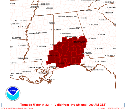
Tornado Watch Number 22
NWS Storm Prediction Center Norman OK
1150 AM CST Wed Feb 5 2020

The NWS Storm Prediction Center has issued a

* Tornado Watch for portions of
Central Louisiana
Central and Southwest Mississippi

* Effective this Wednesday morning and evening from 1150 AM until
600 PM CST.

* Primary threats include...
A few tornadoes likely with a couple intense tornadoes possible
Scattered damaging wind gusts to 70 mph possible
Isolated large hail events to 1.5 inches in diameter possible

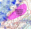
SUMMARY...Thunderstorms are expected to continue to develop over
central Louisiana this afternoon and spread northeastward across the
watch area. A few supercell storms are possible, capable of
damaging winds and tornadoes.

Probability of 2 or more tornadoes
High (70%)​
Probability of 1 or more strong (EF2-EF5) tornadoes
Mod (40%)​
 
Back
Top