CheeselandSkies
Member
Phew, it's gonna go east of Rolling Fork
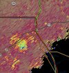
Warning extended. Couplet is modest but persistent. Located just northwest of Holly Bluff.
Follow along with the video below to see how to install our site as a web app on your home screen.
Note: This feature may not be available in some browsers.
Phew, it's gonna go east of Rolling Fork
Been kind of bizarre to look at. It's almost like storm outflow is being pushed back into the line and causing these wild signatures to show upSymmetry on the velocity just seems too fishy for hail spikes, even though VIL shows a good bit of hail in these storms. Looking at it from KPAH, KHPX and KOHX shows there is definitely a strong signature there.
View attachment 33887View attachment 33888
Right. Basic wisdom would tell you this is a potentially intense tornado with a TDS, but it's not lining up with reflectivity (I checked to make sure scans are chronologically synchronized). At the same time, I'm not convinced there isn't a strong meso in this location, so I'm not sure what to make of it.Been kind of bizarre to look at. It's almost like storm outflow is being pushed back into the line and causing these wild signatures to show up

Wind drivenWind or tornado?

extreme isolated CC drop near Paris and possible power flashes on a skycam (radar omega)
50-70% that's relatively high