
Navigation
Install the app
How to install the app on iOS
Follow along with the video below to see how to install our site as a web app on your home screen.
Note: This feature may not be available in some browsers.
More options
-
Welcome to TalkWeather! We see you lurking around TalkWeather! Take the extra step and join us today to view attachments, see less ads and maybe even join the discussion. CLICK TO JOIN TALKWEATHER
You are using an out of date browser. It may not display this or other websites correctly.
You should upgrade or use an alternative browser.
You should upgrade or use an alternative browser.
2/15/25 SE Severe Threat
- Thread starter Jason Mills
- Start date
-
- Tags
- severe weather
Even if they do include it, it's a pain. It's not too difficult to say "this sounding was taken in Union County MS at about 6 pm"I often wondered why these readings don't include the longitude and latitude they're taken from, whether you put the location or not.
Ledian
Member
Areas affected...parts of southern and eastern Arkansas and adjacent
portions of northwestern Louisiana...northwestern Mississippi and
western Tennessee
Concerning...Severe potential...Watch likely
Valid 151906Z - 152200Z
Probability of Watch Issuance...80 percent
SUMMARY...A corridor of intensifying thunderstorm development
appears likely east of the Ark-La-Tex northeastward toward the
Greater Memphis vicinity through 4-6 PM CDT. Initially this may
include a risk for supercells with potential to produce tornadoes,
before storms consolidate into an organizing line.
DISCUSSION...A baroclinic zone on the northwestern periphery of
warm, moist southerly return flow from the western Gulf has been
reinforced by persistent warm advection driven weak convective
development. Differential heating is contributing to strengthening
of the thermal gradient, and a slow northward advancement of the
front at the surface, toward the Memphis TN, Pine Bluff and El
Dorado AR vicinities. Surface observations indicate that a focused
area of stronger surface pressure falls (2-3+ mb/2 hourly) is
already developing to the west/northwest of Little Rock as of 18Z,
and models indicate that this boundary will become the focus for
strengthening surface cyclogenesis later this afternoon into
tonight.
Upstream, it appears that a significant approaching short wave
trough will maintain a general positive tilt as it progresses
eastward across the southern Great Plains into early evening.
However, models suggest that increasingly difluent/divergent flow
ahead of it will contribute to increasing forcing for ascent along
the frontal zone by 21-23Z.
Although it is possible that this may remain largely focused
above/just to the cool side of the front, there may be a window of
opportunity for sufficient weakening of mid-level inhibition, in a
narrow corridor just ahead of the front, to support thunderstorm
initiation rooted within an unstable boundary-layer characterized by
CAPE up to 1000 J/kg. Within this regime, low-level hodographs,
beneath 50+ kt south-southwesterly flow around 850 mb, are already
sizable and clockwise curved, and conducive to the evolution of
strong low-level mesocyclones with the potential to produce
tornadoes.
Cyclonic Paracosm
Member
a watch alr is unreal
Watch likely across parts of ArkLaMiss.
Mesoscale Discussion 0098
NWS Storm Prediction Center Norman OK
0106 PM CST Sat Feb 15 2025
Areas affected...parts of southern and eastern Arkansas and adjacent
portions of northwestern Louisiana...northwestern Mississippi and
western Tennessee
Concerning...Severe potential...Watch likely
Valid 151906Z - 152200Z
Probability of Watch Issuance...80 percent
SUMMARY...A corridor of intensifying thunderstorm development
appears likely east of the Ark-La-Tex northeastward toward the
Greater Memphis vicinity through 4-6 PM CDT. Initially this may
include a risk for supercells with potential to produce tornadoes,
before storms consolidate into an organizing line.
DISCUSSION...A baroclinic zone on the northwestern periphery of
warm, moist southerly return flow from the western Gulf has been
reinforced by persistent warm advection driven weak convective
development. Differential heating is contributing to strengthening
of the thermal gradient, and a slow northward advancement of the
front at the surface, toward the Memphis TN, Pine Bluff and El
Dorado AR vicinities. Surface observations indicate that a focused
area of stronger surface pressure falls (2-3+ mb/2 hourly) is
already developing to the west/northwest of Little Rock as of 18Z,
and models indicate that this boundary will become the focus for
strengthening surface cyclogenesis later this afternoon into
tonight.
Upstream, it appears that a significant approaching short wave
trough will maintain a general positive tilt as it progresses
eastward across the southern Great Plains into early evening.
However, models suggest that increasingly difluent/divergent flow
ahead of it will contribute to increasing forcing for ascent along
the frontal zone by 21-23Z.
Although it is possible that this may remain largely focused
above/just to the cool side of the front, there may be a window of
opportunity for sufficient weakening of mid-level inhibition, in a
narrow corridor just ahead of the front, to support thunderstorm
initiation rooted within an unstable boundary-layer characterized by
CAPE up to 1000 J/kg. Within this regime, low-level hodographs,
beneath 50+ kt south-southwesterly flow around 850 mb, are already
sizable and clockwise curved, and conducive to the evolution of
strong low-level mesocyclones with the potential to produce
tornadoes.
..Kerr/Smith.. 02/15/2025
Storm Prediction Center Mesoscale Discussion 98
Severe weather, tornado, thunderstorm, fire weather, storm report, tornado watch, severe thunderstorm watch, mesoscale discussion, convective outlook products from the Storm Prediction Center.
www.spc.noaa.gov
I think they're talking about a tornado moderate. But honestly I think a moderate wind risk would be appropriate either way, severe damaging wind gusts can be as bad as tornadoes sometimes.Based on wind?
Justin Hindman
Member
- Messages
- 378
- Reaction score
- 1,165
- Location
- Gardendale Alabama
- Special Affiliations
- SKYWARN® Volunteer
- ARRL Member
I’m gonna throw my prediction on here and I won’t change it. Mostly a line with a few intense tornadoes, not long track, the storms in front will struggle to get going, might have a tornado warning or two but won’t hold their circulation. I hope I’m right, if they do get going, long day
Quite a large rain free area for the warm sector to easily expand in
Going to be a tough task of watching Alabamas basketball game and the weather at the same time lol.
Cyclonic Paracosm
Member
yeahQuite a large rain free area for the warm sector to easily expand in
Cyclonic Paracosm
Member

Geno
Member
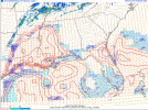
Can someone explain what I'm looking at on the hodograph? If this is not the right place for that question, I understand.
Small, rounded hodographs, exhibiting some VBV. Not incredibly conducive to tornadoes for now, but that will change as evening approaches.Can someone explain what I'm looking at on the hodograph? If this is not the right place for that question, I understand.
Kds86z
Member
By then may be to late.. Small, rounded hodographs, exhibiting some VBV. Not incredibly conducive to tornadoes for now, but that will change as evening approaches.

Depending on the channel, you might get to do both.Going to be a tough task of watching Alabamas basketball game and the weather at the same time lol.
Ole Miss vs MSU at 5 pm in Oxford will be interesting...potentially perfect location at just the right time for the weather threat in that area.
- Thread starter
- #317
Jason Mills
Member
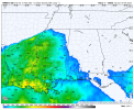
Surface temperatures are running a few degrees warmer across central/northern MS than what was progged by RAP/HRRR earlier today. Dewpoints seem to be on the money.
Ledian
Member
SPC continues to maintain the Enhanced risk. So whether or not there is a Moderate will probably depend on how the initial storms ahead of the main line behave
Kds86z
Member
MDT is not gonna happen…SPC continues to maintain the Enhanced risk. So whether or not there is a Moderate will probably depend on how the initial storms ahead of the main line behave
18Z NAM and HRRR favoring different areas for severe convection. NAM focused on ArkLaMiss into NE MS and N AL, while HRRR favors Memphis metro, ArkLaMiss and southern AL. Models have been less-than-stellar at capturing actual conditions, but I think this gives some perspectives at possible modal evolutions this evening. Would definitely be on my toes this afternoon into the evening across eastern AR, northern MS and western TN. What happens further east will just depend on how convection evolves.

