Ledian
Member
66 degrees and rising
Follow along with the video below to see how to install our site as a web app on your home screen.
Note: This feature may not be available in some browsers.
I’m not too impressed either, but I have learned in set ups like this to never let my guard down as anything can happen.

Really liking your more detailed posts, keep it up man!Main change at 1630Z is the addition of a 45% wind contour. SPC anticipates potentially prolific wind threat as the QLCS consolidates. NCAR's CAM analysis models, which I like to use as an additional reference point, maintains strong probabilities for damaging winds, and a secondary threat of tornadoes, well into the night all the way through the morning Sunday. CAM suites still suggest a potent QLCS tornado and damaging wind threat, and HRRR has picked up on some possible discrete activity just out ahead of the QLCS. Not sure it amounts to a meaningful threat, but the signal is there. Regardless of the threat for long-tracked tornadoes, everyone should be prepared for severe storms this evening through Sunday morning in the Deep South.
View attachment 33796View attachment 33797View attachment 33798View attachment 33799View attachment 33800View attachment 33801View attachment 33802View attachment 33803
Wind driven moderate?I think we see an upgrade to Moderate.
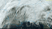
Very concerning. No rain in most of the state right now.Definitely getting rapid clearing on visible satellite
it sure is odd that it isn't a wind driven moderate , today seems perfect for a moderate rating.Wind driven moderate?

Memphis metro is clearing up despite not being forecasted to clear up this early (if at all).As others are mentioning, something that's a bit concerning for all of us is that there's no huge rain shield setting up right over I-20, like there often is in severe setups. TN/KY is getting slammed by flooding rains, but for the rest of us it's mostly dry.
View attachment 33809
just had to say something didn't youyeah still not super impressed with the OWS potential with this one, weak forcing, weak surface heating, etc. could be a nasty QLCS though.
Same!!!!Really liking your more detailed posts, keep it up man!

I can hear Reed's heavy breathing from here.View attachment 33810
we are truly cooked
I can confirm my yard is basically a pool at this point, southern Kentucky.As others are mentioning, something that's a bit concerning for all of us is that there's no huge rain shield setting up right over I-20, like there often is in severe setups. TN/KY is getting slammed by flooding rains, but for the rest of us it's mostly dry.