- Moderator
- #621
Wait what movie is this? Don’t say it’s Twisters
Yep
Follow along with the video below to see how to install our site as a web app on your home screen.
Note: This feature may not be available in some browsers.
Wait what movie is this? Don’t say it’s Twisters
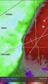
BULLETIN - EAS ACTIVATION REQUESTED
Tornado Warning
National Weather Service Jackson MS
1004 PM CST Sat Feb 15 2025
The National Weather Service in Jackson has issued a
* Tornado Warning for...
Rankin County in central Mississippi...
Southeastern Hinds County in central Mississippi...
* Until 1100 PM CST.
* At 1004 PM CST, a severe thunderstorm capable of producing a
tornado was located near Raymond, moving east at 55 mph.
HAZARD...Tornado.
SOURCE...Radar indicated rotation.
IMPACT...Flying debris will be dangerous to those caught without
shelter. Mobile homes will be damaged or destroyed.
Damage to roofs, windows, and vehicles will occur. Tree
damage is likely.
* This dangerous storm will be near...
Jackson, Richland, and Byram around 1010 PM CST.
Flowood and Pearl around 1015 PM CST.
Brandon and Monterey around 1020 PM CST.
Fannin around 1025 PM CST.
Pelahatchie, Pisgah, and Goshen Springs around 1035 PM CST.
Leesburg around 1040 PM CST.
PRECAUTIONARY/PREPAREDNESS ACTIONS...
TAKE COVER NOW! Move to a basement or an interior room on the lowest
floor of a sturdy building. Avoid windows. If you are outdoors, in a
mobile home, or in a vehicle, move to the closest substantial shelter
and protect yourself from flying debris.
&&
LAT...LON 3225 9051 3240 9021 3240 9007 3244 9007
3244 9004 3248 9002 3248 8999 3250 8998
3249 8996 3254 8989 3256 8989 3256 8987
3259 8983 3259 8979 3236 8973 3221 8973
3208 9043
TIME...MOT...LOC 0404Z 248DEG 49KT 3221 9037
TORNADO...RADAR INDICATED
MAX HAIL SIZE...<.75 IN

Sigh… ok

It'll do millions of dollars of improvements to the Jackson radar if it's on the ground.Tornado warning headed directly toward a radar site, big shocker

Just warned@JPWX be prepared. Storm SW of Shannon starting to look interesting.