
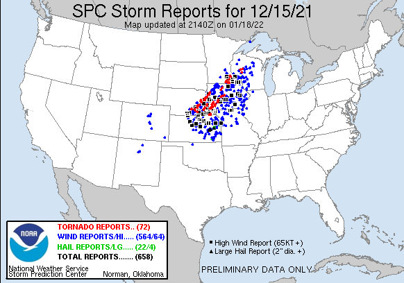
Just tracking one severe weather outbreak while breathlessly awaiting survey updates on the one that occurred five days ago. #JustMaycemberThings
Corrected that for you.

Follow along with the video below to see how to install our site as a web app on your home screen.
Note: This feature may not be available in some browsers.
Just tracking one severe weather outbreak while breathlessly awaiting survey updates on the one that occurred five days ago. #JustMaycemberThings
The line is moving into the MDT area now. I guess the question is whether we get discrete supercellular development ahead of the line at some point.
Do we know if there are going to be any special soundings from e.g. Des Moines?
Yeah, mesoanalysis has eastern Iowa still capped for now, but it looks like the cap has eroded in the area immediately in front of the line in west-central Iowa.I don't know about special soundings, but the HRRR forecast soundings from a few runs ago showed some SBCINH remaining ahead of the line which *should* keep it as the only game in town...but it's quite a game.
