• Welcome to TalkWeather!
    We see you lurking around TalkWeather! Take the extra step and join us today to view attachments, see less ads and maybe even join the discussion.
    CLICK TO JOIN TALKWEATHER

5/5-5-6 2026 severe threat

***********The WSR-88D radar (KBMX) serving Central Alabama is currently out of service due to a hardware failure as of 07:05 A.M. this morning.

National Weather Service technicians have been working continuously to diagnose and repair the issue, and replacement parts are being expedited to restore service as quickly as possible.
Oh, perfect :rolleyes:
 
i think alabama’s jefferson county sees its first tornado warning in 5 years today.

appreciable threat with a very high ceiling and a decently low floor. if we get into the 80s and see a little more active LLS, bad bad news for a seasoned central AL crowd that hasn’t had to deal with tornadoes in a long time
 
***********The WSR-88D radar (KBMX) serving Central Alabama is currently out of service due to a hardware failure as of 07:05 A.M. this morning.

National Weather Service technicians have been working continuously to diagnose and repair the issue, and replacement parts are being expedited to restore service as quickly as possible.
Pfft, what a coincidence. If I was a nutjob I'd say that mother nature is tampering with the radars!
 
It will be interesting to watch how the southern edge of this precipitation across far northern AL evolves this morning. A little stronger than most CAMs projected, but not much southward movement. This should create a good thermal boundary that may factor into today.
Given relatively modest forcing, any boundaries set up by this stuff is may be a primary focus for later convective initiation.
 
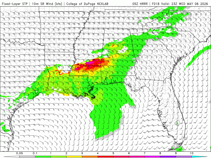
While I have my doubts about today being an outbreak, there remains a conditional potential for a somewhat sizable corridor for several strong tornadoes and an intense tornado cannot be ruled out if a mature supercell has favorable interactions.

The main limiting factors I see have already been discussed in the form of an absent EML in an area with a very moist layer, as well as slightly lacking lower level shear. However Dixie has been shown to be able to overcome weaker shear but crapvection remains the main limiting factor for me. If you can't get a supercell that has enough space then the tornado threat is limited from what it could be.

However, satellite imagery shows a large and growing area of clearing in central AL, as well as an OFB pushing SSE. If the clearing continues into MS then further daytime heating might allow for more instability than forecast, along with the possibility of a slightly dryer layer than forecast, which of course would get rid of some crapvection and give our main cells some more breathing room.

While it might not be a great chasing day, we could see some classic Dixie HP supercells on radar and maybe an intense tornado or two (especially with the possibility of instability over performing expectations due to the growing clearing)
 
Another annoying high-ceiling/low floor day. Could be anything from a mediocre slopfest to a localized corridor of high-end tornado production, kind of like the Beauregard day in March 2019 or that day in mid-January 2023.
 
Another annoying high-ceiling/low floor day. Could be anything from a mediocre slopfest to a localized corridor of high-end tornado production, kind of like the Beauregard day in March 2019 or that day in mid-January 2023.
Funny you brought that up because I was going to say that you literally never know for sure with Dixie events like this. Dixie alley can have a knack for sneaking up on you and producing an intense to violent tornado out of an environment like we might see later. Even on days where the lack of a cap is a major factor with marginal lapse rates and an over saturated profile, we can often see one storm go briefly nuts.
 
I feel like the HRRR has been quite off this year when depicting higher ceiling events. While I can see the ceiling being quite solid today, I’m not sold on an outbreak at all. The mode is practically guaranteed to be messy today. I wonder why there’s no EML… Isn’t the drought out west supposed to be quite strong at this point in the season?
 
While it might not be a great chasing day, we could see some classic Dixie HP supercells on radar and maybe an intense tornado or two (especially with the possibility of instability over performing expectations due to the growing clearing)
I wouldn't chase anywhere in the Central MS/Central AL corridor today, especially when the mode will possibly be clustered. Tornadoes are both very fast moving in the region and the tree cover could easily be deadly when paired with the rainwrapped nature of most dixie tornadoes.

Quick forum callout: if you're new to chasing and want to chase a Dixie setup, don't even think aboout it unless it's specifically centered in North Alabama or Western Mississippi with HP supercells being off the table. And even then, still not worth the risk.
 
IMG-1241.gif


Got to get to Bassfield! Lmbo :D
 
CAMs maximize convective potential in the early-to-mid evening in a corridor from the Arklamiss triple-point along I-20 into far western Georgia. Combine that with clearing ongoing over parts of MS/AL/GA already at 10 AM, and it definitely smells like there could be at least some trouble somewhere in the Southeast today. I'd reckon core areas to watch out for are discrete development in southern MS - though questionable, if cells materialized there, strong tornadoes would definitely be possible - as well as in the I-20 corridor from Birmingham to west of Atlanta, where favorable mergers and boundary-riders with the QLCS could locally maximize tornado potential. Definitely a messy, mixed-mode day, but like @CheeselandSkies said, the ceiling and floor are very far-separated today.
qbAh9xP.png
KuOvkJP.gif
LqhZwQ6.gif
HQx1pTI.gif
 
Back
Top