
Astronomy/physics is my main field, meteorology is just something I love on the side. I have an obsession with really extreme things in nature which is probably why I am so into severe weather, as well as stuff in space, lol. And I do agree, IMO R136 is the best because it's got the massive, most extreme stars.PS. I really like your R136 profile pic. Nice to see another space fan (I've always loved stargazing).
Navigation
Install the app
How to install the app on iOS
Follow along with the video below to see how to install our site as a web app on your home screen.
Note: This feature may not be available in some browsers.
More options
-
-
Welcome to TalkWeather! We see you lurking around TalkWeather! Take the extra step and join us today to view attachments, see less ads and maybe even join the discussion. CLICK TO JOIN TALKWEATHER
You are using an out of date browser. It may not display this or other websites correctly.
You should upgrade or use an alternative browser.
You should upgrade or use an alternative browser.
Severe Weather 2025
- Thread starter KevinH
- Start date

tennessee storm chaser
Member
- Messages
- 1,624
- Reaction score
- 3,062
- Location
- jackson tennessee
- Special Affiliations
- SKYWARN® Volunteer
Chomping at bit for a good storm chase day before colder air settles in down the road …. Hoping we don’t waste a good pattern coming up next couple weeks get good fall severe wx event….. still I would watch later next week timeframe
- Moderator
- #7,503
Regarding the end of next week...
During the Day 6-8 period, forecast model spread increases
considerably. However, a general trend indicating a deepening trough
across the West ejecting across the Plains toward the central U.S.
Thursday and Friday is apparent. Depending on the evolution of this
feature and any developing surface cyclone and attendant Gulf return
flow across the south-central U.S., an increase in severe
thunderstorm potential could develop. Large spread and poor
run-to-run consistency among various guidance precludes
probabilities at this time.
The most recent 0z ICON is a pretty dangerous looking run next week. Seems like there’s been a bit of an uptrend as well with the GDPS and GFS.


Also seeing some pretty crazy numbers with this too. This run is a bit of an outlier at the moment, though.
Also seeing some pretty crazy numbers with this too. This run is a bit of an outlier at the moment, though.
- Moderator
- #7,505
ALL OVER THE PLACE
CheeselandSkies
Member
Still not really seeing a coherent signal across the models for anything high-end. If one does show up, it keeps getting pushed further out in time. Of course, this time of year it's hard to pin down anything with the thermodynamics using the globals, but even the crucial trough geometry keeps changing every run. Best chance still looks to be in the 20th-21st timeframe.
- Messages
- 4,618
- Reaction score
- 9,540
- Location
- California, United States
- Special Affiliations
- SKYWARN® Volunteer

This look on the EPS mean would likely yield some severe weather over TX/adjacent areas on Thursday, magnitude TBD of course.
AJS
Member
No matter the magnitude, I’m keeping this on high alert for sure.View attachment 48650
This look on the EPS mean would likely yield some severe weather over TX/adjacent areas on Thursday, magnitude TBD of course.
WeathermanLeprechaun
Member
The 20th/21st is definitely the timeframe to watch, with the possibility of all severe hazards but the magnitude really is still inconclusive. I would be watching Eastern TX on the 20th and MS/AL for the 21st as the system pretty much decays in terms of svr potential there.
On the other hand, it's a good thing that we don't have at least some instability to take advantage of THESE wind profiles in NE OH/W PA today.
On the other hand, it's a good thing that we don't have at least some instability to take advantage of THESE wind profiles in NE OH/W PA today.
Attachments
AJS
Member
Yeah, the 20/21st next week does seem like the period to watch. Considering Texas seems to be where all severe hazards are possible, I have this on high alert.The 20th/21st is definitely the timeframe to watch, with the possibility of all severe hazards but the magnitude really is still inconclusive. I would be watching Eastern TX on the 20th and MS/AL for the 21st as the system pretty much decays in terms of svr potential there.
On the other hand, it's a good thing that we don't have at least some instability to take advantage of THESE wind profiles in NE OH/W PA today.
I sent this out this past Thursday to my weather text subscribers:
"Nov. 20th thru 26th: Will be monitoring for severe storm potential."
"Nov. 20th thru 26th: Will be monitoring for severe storm potential."
Ozonelayer
Member
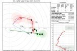
Latest GFS has a hell of a hodograph in south-central Texas and near the Texas/Mexico border on the 20th. Environment doesn't seem all too bad either.


AJS
Member
Thats quite the sounding this far out from the 20th.Latest GFS has a hell of a hodograph in south-central Texas and near the Texas/Mexico border on the 20th. Environment doesn't seem all too bad either.
View attachment 48652
WeathermanLeprechaun
Member
Pretty typical of South Central TX with those strong moist layer/inversion combos, i believe the environment wouldn't support anything firing with the scenario the GFS sets all day here. Regardless, that hodograph would support cyclical tornado behavior if this scenario were to be utilised by a supercell.Latest GFS has a hell of a hodograph in south-central Texas and near the Texas/Mexico border on the 20th. Environment doesn't seem all too bad either.
WeathermanLeprechaun
Member

WeathermanLeprechaun
Member
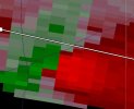
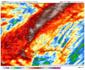
This cell continues to strengthens its rotation despite a fairly marginal thermodynamic environment. The low level kinematics are absolutely carrying this thing. I would consider getting into shelter if you live near Clintonville, PA!
Severe just issued as i type this, tornado possible tag!
Severe just issued as i type this, tornado possible tag!
Attachments
WeathermanLeprechaun
Member

The 12z Canadian and Euro Operational show a lot more rainfall thru next 10 days than the GFS. I tend to agree with the Canadian and Euro showing a more active/robust pattern as it makes sense.
Attachments

- Thread starter
- #7,520
KevinH
Member
I love your posts man!The 12z Canadian and Euro Operational show a lot more rainfall thru next 10 days than the GFS. I tend to agree with the Canadian and Euro showing a more active/robust pattern as it makes sense.