
WeathermanLeprechaun
Member
Tagging @Marshal79344 since this post is inspired by his post on X about this a bit back and figured I'd share it.
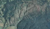
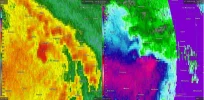
On 5/8/2009, a "EF1" struck rural areas near Ellington, MO. Despite the EF1 rating, satellite just a few months later revealed a estimated 1.25 mile wide swath of likely intense tree damage. It is not far off to say EF3-EF4 intensity was reached with this tornado but due to its rating, this is all we can go off on.
On 5/8/2009, a "EF1" struck rural areas near Ellington, MO. Despite the EF1 rating, satellite just a few months later revealed a estimated 1.25 mile wide swath of likely intense tree damage. It is not far off to say EF3-EF4 intensity was reached with this tornado but due to its rating, this is all we can go off on.