100%.
A lot of the attention from that day goes to the Tuscaloosa supercell and rightfully so, but the Cordova supercell was the supercell of the day in my opinion. The incipient stage of the cell actually merged with the ongoing supercell that had already dropped the Philadelphia, MS EF5 before it crossed the Alabama line. Then shortly after crossing into Alabama it dropped the aforementioned Cordova EF4. Then throughout its life it would drop the Rainsville EF5, the Ringgold EF4, an EF3 in northeastern Tennessee, and finally a few weaker tornados in southwestern Virginia. I’m sure it also dropped some weaker tornados in the rural, mountainous areas of eastern Tennessee.
Now, in the confines of the scale, there is nothing controversial over the Cordova rating. However, as
@CheeselandSkies and
@slenker mentioned,
the environment it was operating in was legitimately as maxed out as you’ll see. As Spann and Simpson watched the storm, it went from an area of a 15.3 STP to an area of 17.5! Which was legitimately mind blowing to both of them. Keep in mind, it’s one thing to see models spit out those values in la la land 3 days before an event, or to see it in a completely capped off plains environment. It’s another to see it actually observed with a fully mature, discrete supercell operating within it. So I completely believe at multiple times in its lifecycle it hit 200+.
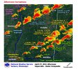
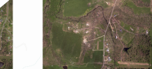
Here is a graphic of the evolution of each supercell in NWS Jackson’s area that they posted on their site from that day. Due to the extreme parameter space, look at just how fast the newly born Cordova cell merged with the Philadelphia cell and proceeded to drop a tornado. In the span of ten minutes, merger and all, it developed a perfect shape and dropped a 115+ mile tornado.