
CheeselandSkies
Member
Things like that are disappointing and a bit unsettling. I once thought the whole "Officially, this tornado has a path well over 100 miles but it actuality it was probably a family" thing was a relic of the distant past.
Follow along with the video below to see how to install our site as a web app on your home screen.
Note: This feature may not be available in some browsers.

Just saw Trey post on Twitter that he was delayed doing his 5/31/85 video due to his tour guide thing but he will get to it
Indeed; well ever since Vilonia we've seen how incompetent NWS offices can be, so it's not that surprising, at least to me.Things like that are disappointing and a bit unsettling. I once thought the whole "Officially, this tornado has a path well over 100 miles but it actuality it was probably a family" thing was a relic of the distant past.

Scratch that, we did manage to find a free video taken from a backyard in Somerset.Also, while we're on Somerset, has anybody seen any public domain, non-security-footage images/videos of the tornado? On Wikipedia we're scouring the internet for any public domain photo/video of the tornado that doesn't come from security videos (the airport security cam video is crap quality), but have been virtually unsuccessful.
Tornado Archive's 2024 edition came out, finally!!
View attachment 43536
Speaking of which, what do we think is the most "forgotten" tornado of 2024? I'd have to go with the April 27 Sulphur EF3.

I'm also of the opinion that the outbreak was probably larger than has been recorded, and probably much more violent overall.
I found evidence of multiple undocumented tornadoes from 5/31/85 as well (including clearly visible scars) without even specifically meaning to look for them. In the last week or two I've also heard from multiple people who gave accounts of tornadoes in several locations across Ontario that aren't officially recorded.While I hesitate to call any given event more violent (overrating being more common than underrating for older tornadoes), the true extent of older outbreaks intrigues me, as even relatively unremarkable modern ones can have dramatically more tornadoes recorded than very violent older ones. For example, May 20 2019, well considered a bu$t, had 54 recorded tornadoes of which 39 were main afternoon-evening period. That's more than currently known for March 21 1932, and much more than April 20 1920.
The obvious analogy for the Tri-state outbreak is Dec 10 2021, whose 12Z-12Z 'tornado day' had 68 tornadoes, 24 significant. The Tri-state outbreak has eight recorded sigtors, nine splitting Gallatin. Adding in likely seperate bits of the Tri-state path, and the undocumented Jackson Co IN tornado takes the total tornadoes to twelve. Even if it was a smaller outbreak, it's a long way to a more realistic 40+ number with a greater proportion of weaker tornadoes. It implies three quarters, if not more, must be missing, maybe even including significant ones.
There'll be some events that would increase numbers by spurious paths being split into their respective components. This especially goes for Greensburg or Dodge City-style prolific plains storms. A well documented example is the 1955 Scottsbluff tornadoes, with only three of thirteen tornadoes being in the official record. But it's the violent events that have the most obvious discrepancies, to the point I find it hard to imagine what the outbreak might have looked like. For example, event producing a similar number of violent tornadoes to June 8 1953 will usually have quite a lot more than the 14 recorded that day. But unless they were over Lake Huron, where could they fit?
Better documentation of nocturnal outbreaks must help - there's no way May 6 last year records as many tornadoes fifty years ago. (makes me wonder if there's changes in recorded diurnal distribution. I suppose I could graph it myself). But the number of people looking and ease of reporting must help too. Speheger's May 3 1999 paper notes ten tornadoes with a single source, in what was probably the most chased event to that point, and implies possible non-reports even for that outbreak. For events around the same time, the April 16 1998 Tennessee outbreak left a 400 metre wide, 7 mile long scar in Hardin County I never saw documented before I found it last year. And while Fujita's outbreak surveys were a leap ahead at the time, a much less effective reporting network and his reliance on aerial surveys must be why Palm Sunday 1965 lacks the number of F0/1 tornadoes that must have accompanied the undeniably large number of violent ones.
Aight so I happened to stumble on this post and out of curiosity I referred to the ol' Google and looked up the event. It led me to this article, which I'm not sure of the validity of it, but the author does appear to have at least done his research. And if it's correct, I think Grazulis was right on at least the "strongest in Colorado history" part.
Sterling-Kelly-LeRoy, Colorado tornado of 1947
Article written by Jonah Bailey, a 14 year old who has invested years into researching historical weather events, especially violent tornadoes, in the US State of Colorado. This study or reanalysis of this event is meant to make important information on this tornado and it’s impacts more easily...tornado-database.fandom.com
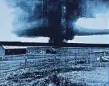
First, a photo of the tornado itself:
View attachment 42587
Anywho, this was a farmstead owned by Marvin Felzein. Apparently it was a pretty large building judging by the size of the foundation but it didn't matter, the building was still quite literally smashed to splinters.
View attachment 42595
Photo documentation ends there, but textual evidence (if fully truthful, take it with a grain of salt) fills in a number of gaps. Among the most impressive claims:
All in all, I am fairly convinced that this was an F5 and the strongest in Colorado state history. Not the largest (the author of this article has an entire database on strong-violent Colorado tornadoes and he estimated the 1925 Wray tornado as being two miles wide at minimum), but still over a mile wide, and the distance involved between the relevant structures proves it.
- Essentially every single structure on all of the eight (!) farmsteads it directly hit was swept completely away. Apparently photos exist for most if not all of the other farmsteads, although if they do the author didn't put them in the article.
- Judging by the rural location, it is likely that no debris loading was involved in the above sweep-aways.
- At the Heist Farmstead, the owner described everything over 2 feet tall as completely gone, which implies the farmstead was essentially vaporized and also may imply that very little debris was left over.
- Not only was large and possibly heavy farm equipment carried (not thrown, carried) away into the tornado at multiple locations, but there was no documentation stating that any of it was found, possibly implying that the farm equipment was either deposited in inaccessible locations Buttermilk 5/23/08-style or completely destroyed.
In conclusion, I think Grazulis was right calling the 1947 Logan County tornado the strongest in Colorado state history, and it rounds out the 1947 "Terrible Trio" of F5s along with Leedey and Woodward.
I haven’t done much research on this, but I think one could fairly conclude that events such as 21–22 Mar 1932 (36+ SIGTOR, including 20+ F3+ tornadoes and at least 10 F4s) probably produced roughly as many weak tornadoes as 2020 Easter (35 SIGTOR, including 16 EF3+ and three F4s). The latter outbreak featured 106 EF0–1 tornadoes. Adding that total and 1932’s Wiki tabulation (38± confirmed) would bring the 1932 Super Outbreak up to 144 tornadoes—very close to 1974’s “official” tally. Back in 1932, of course, probably some of those “weak” events would have been capable of F2+ damage, and I do believe that even Thomas P. Grazulis is likely missing a number of significant events from that outbreak (the NWS in Nashville has done research on several pre-1950 outbreaks within its CWA and found many F2+ events that he overlooked, including deadly ones).While I hesitate to call any given event more violent (overrating being more common than underrating for older tornadoes), the true extent of older outbreaks intrigues me, as even relatively unremarkable modern ones can have dramatically more tornadoes recorded than very violent older ones. For example, May 20 2019, well considered a bu$t, had 54 recorded tornadoes of which 39 were main afternoon-evening period. That's more than currently known for March 21 1932, and much more than April 20 1920.
The obvious analogy for the Tri-state outbreak is Dec 10 2021, whose 12Z-12Z 'tornado day' had 68 tornadoes, 24 significant. The Tri-state outbreak has eight recorded sigtors, nine splitting Gallatin. Adding in likely seperate bits of the Tri-state path, and the undocumented Jackson Co IN tornado takes the total tornadoes to twelve. Even if it was a smaller outbreak, it's a long way to a more realistic 40+ number with a greater proportion of weaker tornadoes. It implies three quarters, if not more, must be missing, maybe even including significant ones.
There'll be some events that would increase numbers by spurious paths being split into their respective components. This especially goes for Greensburg or Dodge City-style prolific plains storms. A well documented example is the 1955 Scottsbluff tornadoes, with only three of thirteen tornadoes being in the official record. But it's the violent events that have the most obvious discrepancies, to the point I find it hard to imagine what the outbreak might have looked like. For example, event producing a similar number of violent tornadoes to June 8 1953 will usually have quite a lot more than the 14 recorded that day. But unless they were over Lake Huron, where could they fit?
Better documentation of nocturnal outbreaks must help - there's no way May 6 last year records as many tornadoes fifty years ago. (makes me wonder if there's changes in recorded diurnal distribution. I suppose I could graph it myself). But the number of people looking and ease of reporting must help too. Speheger's May 3 1999 paper notes ten tornadoes with a single source, in what was probably the most chased event to that point, and implies possible non-reports even for that outbreak. For events around the same time, the April 16 1998 Tennessee outbreak left a 400 metre wide, 7 mile long scar in Hardin County I never saw documented before I found it last year. And while Fujita's outbreak surveys were a leap ahead at the time, a much less effective reporting network and his reliance on aerial surveys must be why Palm Sunday 1965 lacks the number of F0/1 tornadoes that must have accompanied the undeniably large number of violent ones.
I found evidence of multiple undocumented tornadoes from 5/31/85 as well (including clearly visible scars) without even specifically meaning to look for them. In the last week or two I've also heard from multiple people who gave accounts of tornadoes in several locations across Ontario that aren't officially recorded.
The 1899 New Richmond outbreak also comes to mind. It was probably a "small" event as outbreaks/sequences go, but even with the relatively limited info we have to go on, it's clear there were many more tornadoes than officially recorded. I documented and mapped out the ones I was most confident in, but there are bits of info suggesting a widespread (if not necessarily prolific) outbreak ranging from SD and KS all the way to northern MN/WI (possibly even up into ON) and down into IL and maybe MO.
I'm fascinated by the topic of undocumented tornadoes in outbreaks and it's become one of the more exciting aspects of researching historical events for me. As you mentioned, I'd love to go back and look at 6/7-9/53 again through that lens at some point.

I haven't, but I'd be happy to contribute any paths I've mapped out; I've always just assumed they only use "official" data sources so I've never asked Andy about it.One thing I noticed recently with Tornado Archive's latest blog post was this:
View attachment 43900
Have you contributed or are you contributing? Your work here is excellent and if you aren't already I'm sure andyhb could help.
One slightly tangential aspect is documentation. There's an increasing community of (mostly amateur) tornado researchers who are invaluable as this isn't the kind stuff that attracts funding. But as I emphasise people have different interpretations of data - a good example is in your 1936 article, interpreting the Tupelo and Red Bay tornadoes as being continuous when Grazulis has them as seperate. It'd be interesting to know if there's any difference in the sources the two of you used (n.b. not actually asking you to describe it in detail, we don't have Grazulis' sources anyway).
This perhaps comes most into details that may be contentious. In TA's latest update the April 3 1956 Michigan tornadoes have been updated making the tracks atypically wiggly, without info in the listed sources to that level of precision. There's also a 1977 F4 in Manitoba whose source is given as 'Fujita' without a document name. Obviously not everything's digital and linkable, but I think it's important to describe sources sufficiently so someone else could find them if they put in the effort. Because someone else might have a different interpretation or insight.
Speaking of documentation, Grazulis must have had, at one time, an extensive collection of notes on non-significant tornadoes, as he mentions quite a few in his book.
We are in plans to add/modify many tornado paths based on user input, with appropriate QC. If you're in the Discord (I think you are), let us know.I haven't, but I'd be happy to contribute any paths I've mapped out; I've always just assumed they only use "official" data sources so I've never asked Andy about it.
Re: Tupelo-Red Bay, I think I'd probably plot it as two tracks if I were doing it today, tbh. There are scattered damage points throughout the official gap between paths that generally line up well, including some that sounded like descriptions of a tornado (roaring noise, swirling winds, substantial structural/tree damage, etc.), but over time I've tended to lean more conservative in interpreting things like that. I still think it's possible it was a single tornado, but I'm not sure the evidence is really sufficient. There's also aerial imagery from I think summer 1937 available on EarthExplorer (or the National Archives? maybe both?) that doesn't really show much evidence of a continuous path, although that doesn't necessarily mean a lot. It's hard to find signs even in some places where the tornado was 100% confirmably on the ground and doing significant damage.
Anyway, that's actually one of many reasons I've been gradually working on reexamining my older path maps, along with plotting out events I wrote about years ago before I started mapping them, etc. I'll have to check out the 4/3/56 paths on TA too; I mapped some of them out when I was thinking about choosing that for my next article but I don't think I ever finished.
While I hesitate to call any given event more violent (overrating being more common than underrating for older tornadoes), the true extent of older outbreaks intrigues me, as even relatively unremarkable modern ones can have dramatically more tornadoes recorded than very violent older ones. For example, May 20 2019, well considered a bu$t, had 54 recorded tornadoes of which 39 were main afternoon-evening period. That's more than currently known for March 21 1932, and much more than April 20 1920.
