
Navigation
Install the app
How to install the app on iOS
Follow along with the video below to see how to install our site as a web app on your home screen.
Note: This feature may not be available in some browsers.
More options
-
Welcome to TalkWeather! We see you lurking around TalkWeather! Take the extra step and join us today to view attachments, see less ads and maybe even join the discussion. CLICK TO JOIN TALKWEATHER
You are using an out of date browser. It may not display this or other websites correctly.
You should upgrade or use an alternative browser.
You should upgrade or use an alternative browser.
Severe Weather Threat - June 17th-18th, 2023
- Thread starter Taylor Campbell
- Start date
Nadocast...
- Thread starter
- Moderator
- #83
Uh oh this isn’t going to be good.
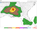
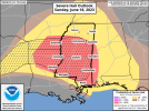
5% Tornado risk now up for Mississippi and West Alabama

Definitely a good place to start. Destabilization well underway in MS and AL.5% Tornado risk now up for Mississippi and West Alabama
View attachment 20696


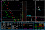
North MS has only had 3 June's where there's been a 5% tornado probability outside of a tropical system: June 8th, 2021 (had a weak tornado in Lee County, MS), June 12th, 2009 (had tornado in DeSoto County, MS), and June 1st, 2008 (5% tornado probability was discontinued though in the 1630z Day 1 Outlook)
GEFS calibrated 4-hour neighborhood tornado probability, 4-hour neighborhood NADOCAST, and 24-hour STP-calibrated neighborhood tornado probability.
Attachments
It's gunna get lit tonight!HRRR intent on late night threat for MS and AL, with some possible development out ahead of the main MCS. Hope people will be aware as they go to bed tonight.
View attachment 20698View attachment 20699

Yeah noticed that, the atmosphere is recovering nicely. Should make the atmosphere a bit more explosive with a more pronounced cold pool aloft from the atmosphere getting worked over this morning.HRRR gradually trending more discrete over past several runs over MS late this evening.
View attachment 20704
- Thread starter
- Moderator
- #95
I'm keeping an eye on the cumulus field across LA into far southern MS. 3KM NAM and HRRR indicate thunderstorm development in this area around 5ish.

I'm getting some sunshine here in Smithville. Current temp is 82 with a dewpoint of 72. Forecasted high is 87.I'm keeping an eye on the cumulus field across LA into far southern MS. 3KM NAM and HRRR indicate thunderstorm development in this area around 5ish.
View attachment 20709
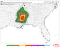
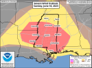
Pretty big 5% Tor risk.Expansion of 5% TOR probability and SIG hatch for large hail from Jackson to Starkville, MS.
Equus
Member
Let's just sit back and continue to realize that we are dealing with the potential of discrete rotating supercells with tornadoes and giant hail, after a whole week of damaging wind/hail and MCS events with a handful of tornadoes and flash flooding, in AL/MS, in mid June
- Thread starter
- Moderator
- #100
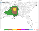
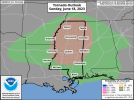
Nadocast added the hatch category. With the parameter set in place EF2+ strength tornadoes seem possible.