• Welcome to TalkWeather!
    We see you lurking around TalkWeather! Take the extra step and join us today to view attachments, see less ads and maybe even join the discussion.
    CLICK TO JOIN TALKWEATHER

Severe WX Severe Wx Outbreak March 1st- 3rd, 2023 - Southern States, MS/OH/TN Valley

If I were out chasing— I probably would have set up out near Tyler, TX or slightly south of there.

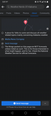
Also, a point of interest, @NWSFortWorth has tweeted out that the warm air cap over D/FW has lifted.

Hold on to your butts!
 
Also as weather fans, we have to be careful to not overhype each system. (Which has been evident on this forum). There’s been one account on TW for the last 6 months or so, and it catches the most heat for posting their opinions which is normally the most reserved/conservative and correct. Yes, eventually we will have stronger systems, maybe even tomorrow, but we can’t act like every system will produce a strong tornado. That’s why many people don’t take it seriously these days. Rant over


Sent from my iPhone using Tapatalk
Not to get off topic, but when that specific user’s wider theory is based on some sort of government and NOAA related “conspiracy” of them purposely upping EF scale ratings of tornados just to somehow prove climate change is making tornados worse it comes across different to me.

I don’t agree with people piling on said user, but their “I told you so posts” do bother others. People on here that do meteorology
professionally for a living, not a hobby, have disproven his theories that climate change is making tornados and outbreaks weaker and rarer over and over. And it somehow goes in one ear and out the other, and he refuses to budge or listen to their points, so you can either learn and admit when you’re wrong, or entrench yourself in an opinion that will not endear you to others.
 
Last edited:
Not really surprising these haven't produced yet. The low-level shear in that area isn't overly impressive, it's really still on the fringes of the hatched TOR area. The most conducive conditions in terms of tornadoes at least aren't really in place yet.
 
Not really surprising these haven't produced yet. The low-level shear in that area isn't overly impressive, it's really still on the fringes of the hatched TOR area. The most conducive conditions in terms of tornadoes at least aren't really in place yet.
Yep, still not in that “spot” yet
 
Yep, still not in that “spot” yet
Yeah, you can see from the sounding that even though there's ample instability south of the front, the low-level shear is still pretty weak that far ahead of the main surface cyclone. There is a pocket of enhanced low-level shear along the boundary that these storms are gradually moving toward, though, so they definitely need to be watched.
 
Can someone explain why Weather Nerds of Alabama's post is wrong? I live in the affected area, and want to know. Saying it's just click bait is not very productive.
Trying not to cause a stir here, but.. it's because there's a warm nose at 700mb that storms will not be able to pass to be able to use those values. So the STP is negligible unless actual forecasts and model show this warm layer being overcame. No reason to really show the STP at this point if storms can't get going. It's nice to see but the general public won't understand the correlation to high STP and tornado potential. A lot of people see the high STP and think there's a high tornado chance in my area.
 
Can someone explain why Weather Nerds of Alabama's post is wrong? I live in the affected area, and want to know. Saying it's just click bait is not very productive.
Presenting a composite index like that without context isn't really helpful. The parameter space is there which is why the STP is high but the storm mode isn't going to be conducive to a threat of strong, long-tracked tornadoes like the composite indices might imply (as well as other factors that have been discussed here like the relatively warm temps in the mid-levels of the atmosphere that will prevent the storms from really being able to tap into those parameters). It's not uncommon to see wild parameter spaces like that in the south this time of year, but usually there are other factors (storm mode, thermodynamic issues, etc.) that hold them back (although it's not usually the mid-levels being too warm).
 
Presenting a composite index like that without context isn't really helpful. The parameter space is there which is why the STP is high but the storm mode isn't going to be conducive to a threat of strong, long-tracked tornadoes like the composite parameters might imply (as well as other factors that have been discussed here like the relatively warm temps in the mid-levels of the atmosphere that will prevent the storms from really being able to tap into those parameters). It's not uncommon to see wild parameter spaces like that in the south this time of year, but usually there are other factors (storm mode, thermodynamic issues, etc.) that hold them back (although it's not usually the mid-levels being too warm).
Thank you, trying not to cause anymore stir, cause I feel we are at a thin line right now with people getting upset, when we have severe threat ongoing.
 
Presenting a composite index like that without context isn't really helpful. The parameter space is there which is why the STP is high but the storm mode isn't going to be conducive to a threat of strong, long-tracked tornadoes like the composite indices might imply (as well as other factors that have been discussed here like the relatively warm temps in the mid-levels of the atmosphere that will prevent the storms from really being able to tap into those parameters). It's not uncommon to see wild parameter spaces like that in the south this time of year, but usually there are other factors (storm mode, thermodynamic issues, etc.) that hold them back (although it's not usually the mid-levels being too warm).
That right there is what has me somewhat concerned… Mid-levels being too warm for this time of year is worrisome in my opinion.
 
Presenting a composite index like that without context isn't really helpful. The parameter space is there which is why the STP is high but the storm mode isn't going to be conducive to a threat of strong, long-tracked tornadoes like the composite indices might imply (as well as other factors that have been discussed here like the relatively warm temps in the mid-levels of the atmosphere that will prevent the storms from really being able to tap into those parameters). It's not uncommon to see wild parameter spaces like that in the south this time of year, but usually there are other factors (storm mode, thermodynamic issues, etc.) that hold them back (although it's not usually the mid-levels being too warm).

Yep. We’d usually be complaining about a warm nose killing snow chances and not severe weather.
 
Thank you, trying not to cause anymore stir, cause I feel we are at a thin line right now with people getting upset, when we have severe threat ongoing.
Oh, yeah, idk, I was just answering their question about why posting the STP image out of context isn't productive. I'm not touching any of the other stuff that's not relevant to today or tomorrow.
 
Ryan Hall just showed on his stream a Twitter video of a veritable "hail blizzard". The cell that caused it is now going over Sherman.
 
They're gonna have to come up with some new colors for the reflectivity to show the size of this hail. That thing is dropping pumpkins.
 
Back
Top